Property Record
N Rochester St, Mukwonago, WI 53149
This Property Is For Sale
NEARBY LISTINGS FOR SALE OR LEASE
Property Detail
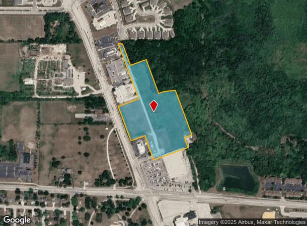
N Rochester St
Milwaukee-Waukesha-West Allis, WI
Certified
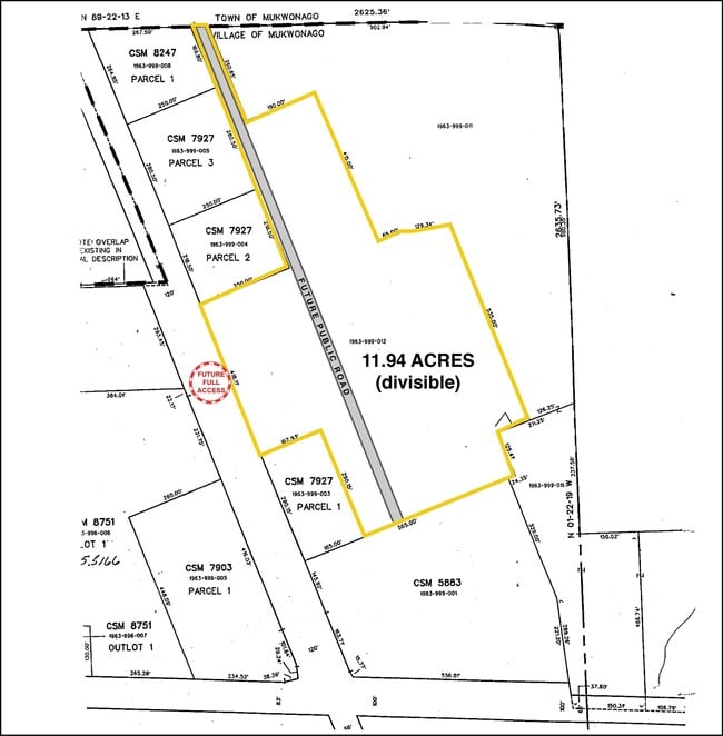
MUKV-1963-999-052
PT SW1/4 & SE1/4 SEC 23 T5N R18E; COM S1/4 CRNR SEC 23; W ON S LINE 319.40 FT TO PNT ON CNTRLNE OF HWY 83; N2036W ALNG CNTRLNE 954.40 FT TO THE BGN; N2048W ALNG CNTRLNE HWY 83 1861.96 FT TO PNT ON E/W 1/4 LINE OF SAID SEC; E ON 1/4 LINE 2471.10 FT; S
Commercialnec
Waukesha
X
Wisconsin
55133C0314H
30
2024
11.94 AC
2024
SW/Mukwonago
203901
Milwaukee/Madison
DEMOGRAPHICS near N Rochester St
1 Mile
3 Mile
5 Mile
2024 Total Population
4,124
14,697
25,775
2029 Population
4,508
15,373
26,706
Pop Growth 2024-2029
+ 9.31%
+ 4.60%
+ 3.61%
Average Age
42
42
43
2024 Total Households
1,650
5,752
9,900
HH Growth 2024-2029
+ 9.64%
+ 4.78%
+ 3.73%
Median Household Inc
$100,247
$97,620
$104,795
Avg Household Size
2.40
2.50
2.60
2024 Avg HH Vehicles
2.00
2.00
2.00
Median Home Value
$287,017
$325,352
$348,557
Median Year Built
1999
1988
1986
Nearby Places
- Restaurants
- Banks
- Shops
- Fitness
- Groceries
PUBLIC TRANSPORTATION
AIRPORT
General Mitchell International
DRIVE
WALK
Distance
General Mitchell International
38 min
27.0 mi
Freight Ports
Port Milwaukee
DRIVE
WALK
Distance
Port Milwaukee
37 min
28.9 mi
Nearby Properties
Address
Land Use
TOTAL SIZE
Lot Size
Zoning
Address
Land Use
TOTAL SIZE
Lot Size
Zoning
15.59 AC
Address
Land Use
TOTAL SIZE
Lot Size
Zoning
21.46 AC
Address
Land Use
TOTAL SIZE
Lot Size
Zoning
4.37 AC
Address
Land Use
TOTAL SIZE
Lot Size
Zoning
15.80 AC
Address
Land Use
TOTAL SIZE
Lot Size
Zoning
14.61 AC
Address
Land Use
TOTAL SIZE
Lot Size
Zoning
17.43 AC
Address
Land Use
TOTAL SIZE
Lot Size
Zoning
41.22 AC
Address
Land Use
TOTAL SIZE
Lot Size
Zoning
10.35 AC
Address
Land Use
TOTAL SIZE
Lot Size
Zoning
12.89 AC
Address
Land Use
TOTAL SIZE
Lot Size
Zoning
12.25 AC
Address
Land Use
TOTAL SIZE
Lot Size
Zoning
10.92 AC
Address
Land Use
TOTAL SIZE
Lot Size
Zoning
11.41 AC
Address
Land Use
TOTAL SIZE
Lot Size
Zoning
Address
Land Use
TOTAL SIZE
Lot Size
Zoning
Address
Land Use
TOTAL SIZE
Lot Size
Zoning
10.97 AC
Address
Land Use
TOTAL SIZE
Lot Size
Zoning
2.32 AC
Address
Land Use
TOTAL SIZE
Lot Size
Zoning
7.50 AC
Address
Land Use
TOTAL SIZE
Lot Size
Zoning
Address
Land Use
TOTAL SIZE
Lot Size
Zoning
4.43 AC
Address
Land Use
TOTAL SIZE
Lot Size
Zoning
9.62 AC
Address
Land Use
TOTAL SIZE
Lot Size
Zoning
3.70 AC
Address
Land Use
TOTAL SIZE
Lot Size
Zoning
3.82 AC
Address
Land Use
TOTAL SIZE
Lot Size
Zoning
Address
Land Use
TOTAL SIZE
Lot Size
Zoning
2.99 AC
Address
Land Use
TOTAL SIZE
Lot Size
Zoning
Address
Land Use
TOTAL SIZE
Lot Size
Zoning
Address
Land Use
TOTAL SIZE
Lot Size
Zoning
Address
Land Use
TOTAL SIZE
Lot Size
Zoning
Address
Land Use
TOTAL SIZE
Lot Size
Zoning
4.81 AC
Address
Land Use
TOTAL SIZE
Lot Size
Zoning
3.19 AC
The World's #1 Commercial Real Estate Marketplace
Connect with us
© 2025 CoStar Group
The information above has been obtained from sources believed reliable. While we do not doubt its accuracy we have not verified it and make no guarantee, warranty or representation about it. It is your responsibility to independently confirm its accuracy and completeness. Any projections, opinions, assumptions, or estimates used are for example only and do not represent the current or future performance of the property. The value of this transaction to you depends on tax and other factors which should be evaluated by your tax, financial, and legal advisors. You and your advisors should conduct a careful, independent investigation of the property to determine to your satisfaction the suitability of the property for your needs.