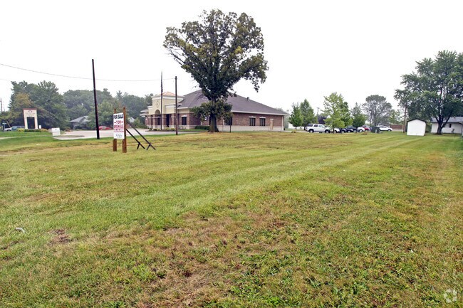
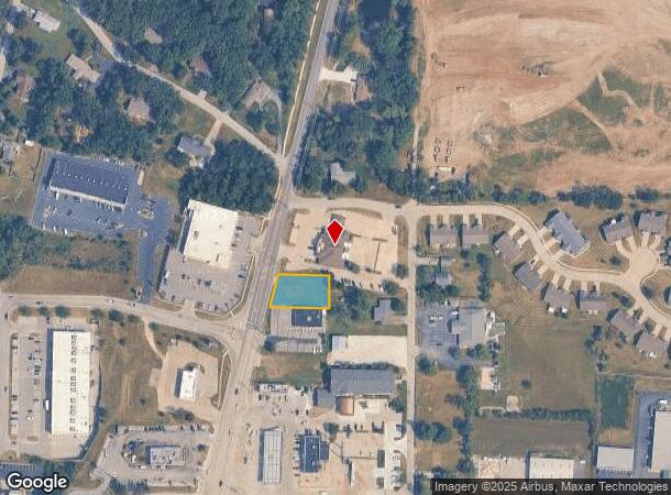
Property Record
1020 N State Highway 47, Warrenton, MO 63383
Current Lease Availabilities
NEARBY LISTINGS FOR SALE OR LEASE
Property Detail
1020 N State Highway 47
05-21.0-1-00-009.000.000
VACANT LAND PT SE 1/4 NE 1/4
Commercialacreage
Warren
X
Missouri
29219C0134D
0.32 AC
2024
Warren County
2024
St. Louis
820105
St. Louis, MO-IL
DEMOGRAPHICS near 1020 N State Highway 47
1 Mile
3 Mile
5 Mile
2024 Total Population
3,674
12,844
18,138
2029 Population
4,171
14,533
20,533
Pop Growth 2024-2029
+ 13.53%
+ 13.15%
+ 13.20%
Average Age
40
39
40
2024 Total Households
1,475
4,947
6,907
HH Growth 2024-2029
+ 13.15%
+ 12.80%
+ 12.84%
Median Household Inc
$46,274
$56,979
$62,636
Avg Household Size
2.50
2.50
2.60
2024 Avg HH Vehicles
2.00
2.00
2.00
Median Home Value
$173,433
$170,745
$182,294
Median Year Built
1996
1997
1998
Nearby Places
Map Layers
Map Styles
 Street
 Aerial
- Restaurants
- Banks
- Shops
- Fitness
- Groceries
Nearby Properties
Address
Land Use
TOTAL SIZE
Lot Size
Zoning
Address
Land Use
TOTAL SIZE
Lot Size
Zoning
16,575 SF
3.70 AC
Address
Land Use
TOTAL SIZE
Lot Size
Zoning
251,900 SF
35.75 AC
Address
Land Use
TOTAL SIZE
Lot Size
Zoning
22,696 SF
4.48 AC
Address
Land Use
TOTAL SIZE
Lot Size
Zoning
157,734 SF
14.80 AC
Address
Land Use
TOTAL SIZE
Lot Size
Zoning
9,828 SF
18.16 AC
Address
Land Use
TOTAL SIZE
Lot Size
Zoning
120,000 SF
39.69 AC
Address
Land Use
TOTAL SIZE
Lot Size
Zoning
158,624 SF
9.44 AC
Address
Land Use
TOTAL SIZE
Lot Size
Zoning
4,320 SF
11.34 AC
Address
Land Use
TOTAL SIZE
Lot Size
Zoning
2,880 SF
17.91 AC
Address
Land Use
TOTAL SIZE
Lot Size
Zoning
39,125 SF
5.19 AC
Address
Land Use
TOTAL SIZE
Lot Size
Zoning
35,919 SF
1.87 AC
Address
Land Use
TOTAL SIZE
Lot Size
Zoning
37,722 SF
6.22 AC
Address
Land Use
TOTAL SIZE
Lot Size
Zoning
113,525 SF
24.82 AC
Address
Land Use
TOTAL SIZE
Lot Size
Zoning
28,500 SF
9.45 AC
Address
Land Use
TOTAL SIZE
Lot Size
Zoning
4,850 SF
2.44 AC
Address
Land Use
TOTAL SIZE
Lot Size
Zoning
5,600 SF
11.50 AC
Address
Land Use
TOTAL SIZE
Lot Size
Zoning
76,000 SF
18.71 AC
Address
Land Use
TOTAL SIZE
Lot Size
Zoning
34,448 SF
17.56 AC
Address
Land Use
TOTAL SIZE
Lot Size
Zoning
10,530 SF
6 AC
Address
Land Use
TOTAL SIZE
Lot Size
Zoning
18,240 SF
0.91 AC
Address
Land Use
TOTAL SIZE
Lot Size
Zoning
2,880 SF
4.61 AC
Address
Land Use
TOTAL SIZE
Lot Size
Zoning
38,085 SF
4.01 AC
Address
Land Use
TOTAL SIZE
Lot Size
Zoning
4,950 SF
50.64 AC
Address
Land Use
TOTAL SIZE
Lot Size
Zoning
7,033 SF
1.56 AC
Address
Land Use
TOTAL SIZE
Lot Size
Zoning
3.71 AC
Address
Land Use
TOTAL SIZE
Lot Size
Zoning
7,260 SF
3.08 AC
Address
Land Use
TOTAL SIZE
Lot Size
Zoning
3,458 SF
2.45 AC
Address
Land Use
TOTAL SIZE
Lot Size
Zoning
3.28 AC
Address
Land Use
TOTAL SIZE
Lot Size
Zoning
4,464 SF
2.79 AC
Address
Land Use
TOTAL SIZE
Lot Size
Zoning
29,662 SF
2.22 AC
The World's #1 Commercial Real Estate Marketplace
Connect with us
© 2025 CoStar Group
The information above has been obtained from sources believed reliable. While we do not doubt its accuracy we have not verified it and make no guarantee, warranty or representation about it. It is your responsibility to independently confirm its accuracy and completeness. Any projections, opinions, assumptions, or estimates used are for example only and do not represent the current or future performance of the property. The value of this transaction to you depends on tax and other factors which should be evaluated by your tax, financial, and legal advisors. You and your advisors should conduct a careful, independent investigation of the property to determine to your satisfaction the suitability of the property for your needs.