Property Record
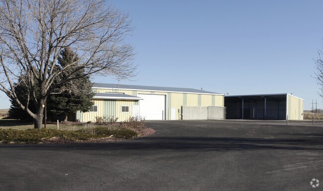
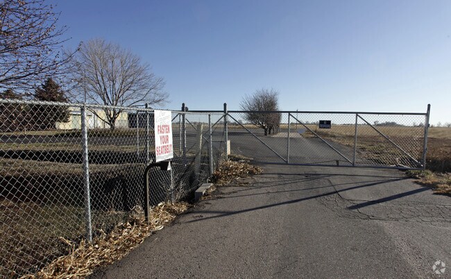
1020 Ne Frontage Rd, Fort Collins, CO 80524

Property Detail
1020 Ne Frontage Rd
87030-06-001
BEG SW COR 3-7-68; TH S 89 32 23 E 1552.85 FT; TH N 47 52 0 W 470 FT; TH N 61 53 30 E 442.37 FT; N 0 5 34 W 158.82 FT; TH S 89 32 23 E 1040 FT; TH N 0 5 34 W 879 FT; TH N 67 41 6 W 1050 FT; TH N 63 36 6 W 495 FT TPOB; TH N 63 36 6 W 340
Commercialnec
Larimer
I
Colorado
B and X Area of moderate flood hazard, usually the area between the limits of the 100-year and 500-year floods.
2-a
2024
14.65 AC
2025
Fort Collins/Loveland
002504
Denver
6,320 SF
Fort Collins-Loveland, CO
NEARBY LISTINGS FOR SALE OR LEASE
DEMOGRAPHICS near 1020 Ne Frontage Rd
1 mile
3 mile
5 mile
2025 Total Population
2,876
16,141
71,584
2030 Population
2,992
16,764
74,186
Pop Growth 2025-2030
+ 4.03%
+ 3.86%
+ 3.63%
Average Age
36
40
38
2025 Total Households
1,072
6,222
28,895
HH Growth 2025-2030
+ 4.20%
+ 3.92%
+ 3.90%
Median Household Inc
$76,344
$93,749
$82,653
Avg Household Size
2.60
2.50
2.30
2025 Avg HH Vehicles
2.00
2.00
2.00
Median Home Value
$468,200
$557,094
$631,674
Median Year Built
2003
2002
1991
Nearby Places
Map Layers
Map Styles
 Street
 Aerial
Transit
 Traffic
 Biking
Places
Listings with unknown addresses are not visible on the map
- Restaurants
- Banks
- Shops
- Fitness
- Groceries
Nearby Properties
Address
Land Use
TOTAL SIZE
Lot Size
Zoning
Address
Land Use
TOTAL SIZE
Lot Size
Zoning
251,556 SF
89.99 AC
Address
Land Use
TOTAL SIZE
Lot Size
Zoning
1,311,585 SF
124.82 AC
I
Address
Land Use
TOTAL SIZE
Lot Size
Zoning
247,848 SF
17.29 AC
PD
Address
Land Use
TOTAL SIZE
Lot Size
Zoning
69,065 SF
11.67 AC
E
Address
Land Use
TOTAL SIZE
Lot Size
Zoning
159,950 SF
31.13 AC
I
Address
Land Use
TOTAL SIZE
Lot Size
Zoning
303.46 AC
O
Address
Land Use
TOTAL SIZE
Lot Size
Zoning
93,000 SF
7.51 AC
Address
Land Use
TOTAL SIZE
Lot Size
Zoning
74,572 SF
4.25 AC
C
Address
Land Use
TOTAL SIZE
Lot Size
Zoning
51,358 SF
2.87 AC
E
Address
Land Use
TOTAL SIZE
Lot Size
Zoning
52,301 SF
4.90 AC
E
Address
Land Use
TOTAL SIZE
Lot Size
Zoning
133,657 SF
14 AC
I
Address
Land Use
TOTAL SIZE
Lot Size
Zoning
88,640 SF
6.27 AC
C
Address
Land Use
TOTAL SIZE
Lot Size
Zoning
71,300 SF
5.42 AC
Address
Land Use
TOTAL SIZE
Lot Size
Zoning
70,506 SF
4.04 AC
C
Address
Land Use
TOTAL SIZE
Lot Size
Zoning
81,020 SF
4.73 AC
I
Address
Land Use
TOTAL SIZE
Lot Size
Zoning
26,250 SF
3.27 AC
E
Address
Land Use
TOTAL SIZE
Lot Size
Zoning
100,778 SF
5.75 AC
C
Address
Land Use
TOTAL SIZE
Lot Size
Zoning
64,215 SF
6.57 AC
I
Address
Land Use
TOTAL SIZE
Lot Size
Zoning
42,088 SF
3.47 AC
E
Address
Land Use
TOTAL SIZE
Lot Size
Zoning
63,398 SF
3.84 AC
C
Address
Land Use
TOTAL SIZE
Lot Size
Zoning
75,749 SF
126.88 AC
R
Address
Land Use
TOTAL SIZE
Lot Size
Zoning
58,700 SF
2.82 AC
C
Address
Land Use
TOTAL SIZE
Lot Size
Zoning
55,384 SF
3.52 AC
C
Address
Land Use
TOTAL SIZE
Lot Size
Zoning
214,488 SF
15.63 AC
MMN
Address
Land Use
TOTAL SIZE
Lot Size
Zoning
31,119 SF
1.86 AC
C
Address
Land Use
TOTAL SIZE
Lot Size
Zoning
39,930 SF
2.52 AC
Address
Land Use
TOTAL SIZE
Lot Size
Zoning
44,940 SF
2.57 AC
I
Address
Land Use
TOTAL SIZE
Lot Size
Zoning
32,548 SF
1.03 AC
C
Address
Land Use
TOTAL SIZE
Lot Size
Zoning
53,580 SF
3.69 AC
PD
Address
Land Use
TOTAL SIZE
Lot Size
Zoning
22,502 SF
2.60 AC
C
The World's #1 Commercial Real Estate Marketplace
Connect with us
© 2026 CoStar Group
The information above has been obtained from sources believed reliable. While we do not doubt its accuracy we have not verified it and make no guarantee, warranty or representation about it. It is your responsibility to independently confirm its accuracy and completeness. Any projections, opinions, assumptions, or estimates used are for example only and do not represent the current or future performance of the property. The value of this transaction to you depends on tax and other factors which should be evaluated by your tax, financial, and legal advisors. You and your advisors should conduct a careful, independent investigation of the property to determine to your satisfaction the suitability of the property for your needs.