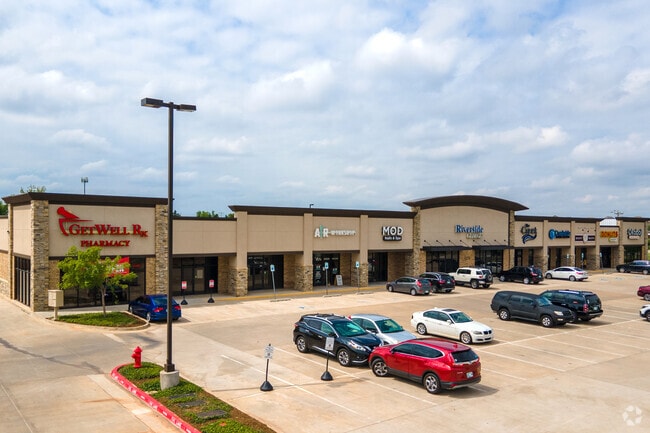
Property Record
1020 Nw 192Nd St, Edmond, OK 73012

NEARBY LISTINGS FOR SALE OR LEASE
Property Detail
1020 Nw 192Nd St
Oklahoma City, OK
Unpltd Pt Sec 28 14N 3W
143647100
UNPLTD PT SEC 28 14N 3W BLK 000 LOT 000 PT NW4 SEC 28 14N 3W BEG 176.99FT E OF NW/C NW4 TH E427.86FT S320FT W427.86FT N318.78FT TO BEG CONT 3.14ACRS MORE OR LESS SUBJ TO ESMTS OF RECORD
Regionalshoppingcenterormallwithanchorstore
Oklahoma
X
Oklahoma
40109C0042J
000
2023
10.71 AC
2024
Edmond
108234
Oklahoma City
27,470 SF
DEMOGRAPHICS near 1020 Nw 192Nd St
1 Mile
3 Mile
5 Mile
2024 Total Population
10,212
73,825
145,617
2029 Population
10,424
75,446
149,302
Pop Growth 2024-2029
+ 2.08%
+ 2.20%
+ 2.53%
Average Age
38
36
37
2024 Total Households
3,421
26,896
57,255
HH Growth 2024-2029
+ 2.16%
+ 2.22%
+ 2.67%
Median Household Inc
$120,747
$94,149
$82,337
Avg Household Size
2.90
2.70
2.50
2024 Avg HH Vehicles
2.00
2.00
2.00
Median Home Value
$274,072
$246,122
$262,008
Median Year Built
2000
2002
1997
Nearby Places
Map Layers
Map Styles
 Street
 Aerial
- Restaurants
- Banks
- Shops
- Fitness
- Groceries
PUBLIC TRANSPORTATION
AIRPORT
Will Rogers World
DRIVE
WALK
Distance
Will Rogers World
37 min
23.8 mi
Freight Ports
Tulsa Port Of Catoosa
DRIVE
WALK
Distance
Tulsa Port Of Catoosa
134 min
121.9 mi
SALE & LEASE HISTORY
LISTING DATE
SALE/LEASE

Sep 25, 2016
For Lease
Mar 07, 2018
For Lease
Jan 17, 2019
For Lease
Nearby Properties
Address
Land Use
TOTAL SIZE
Lot Size
Zoning
Address
Land Use
TOTAL SIZE
Lot Size
Zoning
27.22 AC
PUD
Address
Land Use
TOTAL SIZE
Lot Size
Zoning
304,750 SF
21.76 AC
Address
Land Use
TOTAL SIZE
Lot Size
Zoning
10,811 SF
1.46 AC
PUD
Address
Land Use
TOTAL SIZE
Lot Size
Zoning
274,861 SF
26.01 AC
Address
Land Use
TOTAL SIZE
Lot Size
Zoning
82,162 SF
6.13 AC
Address
Land Use
TOTAL SIZE
Lot Size
Zoning
173,384 SF
5.51 AC
Address
Land Use
TOTAL SIZE
Lot Size
Zoning
151,156 SF
13.71 AC
Address
Land Use
TOTAL SIZE
Lot Size
Zoning
164,940 SF
27.04 AC
Address
Land Use
TOTAL SIZE
Lot Size
Zoning
2,086 SF
11.67 AC
PUD
Address
Land Use
TOTAL SIZE
Lot Size
Zoning
210,018 SF
25.18 AC
Address
Land Use
TOTAL SIZE
Lot Size
Zoning
140,434 SF
18.14 AC
Address
Land Use
TOTAL SIZE
Lot Size
Zoning
8,760 SF
1.05 AC
Address
Land Use
TOTAL SIZE
Lot Size
Zoning
154,244 SF
6.44 AC
PUD
Address
Land Use
TOTAL SIZE
Lot Size
Zoning
8,920 SF
7.83 AC
Address
Land Use
TOTAL SIZE
Lot Size
Zoning
71,902 SF
6.68 AC
Address
Land Use
TOTAL SIZE
Lot Size
Zoning
159,232 SF
14.06 AC
Address
Land Use
TOTAL SIZE
Lot Size
Zoning
75,308 SF
4.03 AC
Address
Land Use
TOTAL SIZE
Lot Size
Zoning
7,840 SF
5 AC
R-1
Address
Land Use
TOTAL SIZE
Lot Size
Zoning
140,144 SF
15.74 AC
Address
Land Use
TOTAL SIZE
Lot Size
Zoning
106,508 SF
2.65 AC
Address
Land Use
TOTAL SIZE
Lot Size
Zoning
121,875 SF
17.45 AC
Address
Land Use
TOTAL SIZE
Lot Size
Zoning
110,250 SF
10 AC
Address
Land Use
TOTAL SIZE
Lot Size
Zoning
2,389 SF
1.63 AC
PUD
Address
Land Use
TOTAL SIZE
Lot Size
Zoning
98,203 SF
4.57 AC
Address
Land Use
TOTAL SIZE
Lot Size
Zoning
55,073 SF
2.61 AC
SPUD
Address
Land Use
TOTAL SIZE
Lot Size
Zoning
74,682 SF
17.68 AC
Address
Land Use
TOTAL SIZE
Lot Size
Zoning
79,348 SF
14.19 AC
Address
Land Use
TOTAL SIZE
Lot Size
Zoning
4,413 SF
5.86 AC
R-1
Address
Land Use
TOTAL SIZE
Lot Size
Zoning
17,243 SF
1.74 AC
Address
Land Use
TOTAL SIZE
Lot Size
Zoning
17,700 SF
1.81 AC
The World's #1 Commercial Real Estate Marketplace
Connect with us
© 2025 CoStar Group
The information above has been obtained from sources believed reliable. While we do not doubt its accuracy we have not verified it and make no guarantee, warranty or representation about it. It is your responsibility to independently confirm its accuracy and completeness. Any projections, opinions, assumptions, or estimates used are for example only and do not represent the current or future performance of the property. The value of this transaction to you depends on tax and other factors which should be evaluated by your tax, financial, and legal advisors. You and your advisors should conduct a careful, independent investigation of the property to determine to your satisfaction the suitability of the property for your needs.