Property Record
1020 Nw Unassigned Ln, Albany, OR 97321
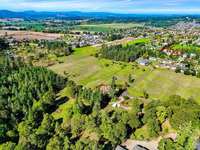
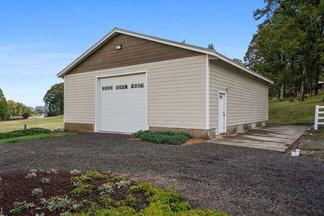
Property Detail
1020 Nw Unassigned Ln
Residentialacreage
BENTON
RS-10
Oregon
B and X Area of moderate flood hazard, usually the area between the limits of the 100-year and 500-year floods.
14.08 AC
2024
Oregon West Area
2025
Other Market Areas
020400
Corvallis, OR
3,870 SF
017206
NEARBY LISTINGS FOR SALE OR LEASE
DEMOGRAPHICS near 1020 Nw Unassigned Ln
1 mile
3 mile
5 mile
2025 Total Population
4,145
26,232
66,552
2030 Population
4,196
26,529
67,754
Pop Growth 2025-2030
+ 1.23%
+ 1.13%
+ 1.81%
Average Age
44
41
41
2025 Total Households
1,491
10,051
25,764
HH Growth 2025-2030
+ 1.14%
+ 1.14%
+ 1.84%
Median Household Inc
$138,475
$84,327
$77,907
Avg Household Size
2.70
2.50
2.50
2025 Avg HH Vehicles
2.00
2.00
2.00
Median Home Value
$602,112
$464,897
$420,172
Median Year Built
1999
1972
1980
Nearby Places
Map Layers
Map Styles
 Street
 Aerial
Transit
 Traffic
 Biking
Places
Listings with unknown addresses are not visible on the map
- Restaurants
- Banks
- Shops
- Fitness
- Groceries
PUBLIC TRANSPORTATION
COMMUTER RAIL
Albany Amtrak Station (Amtrak Cascades - Amtrak, Coast Starlight - Amtrak)
Drive
Walk
Distance
Albany Amtrak Station (Amtrak Cascades - Amtrak, Coast Starlight - Amtrak)
8 min
3.5 mi
Freight Ports
Port of Portland
Drive
Walk
Distance
Port of Portland
99 min
75.2 mi
SALE & LEASE HISTORY
LISTING DATE
SALE/LEASE

Aug 22, 2024
For Sale
Nearby Properties
Address
Land Use
TOTAL SIZE
Lot Size
Zoning
Address
Land Use
TOTAL SIZE
Lot Size
Zoning
1.94 AC
Address
Land Use
TOTAL SIZE
Lot Size
Zoning
33,540 SF
2.19 AC
ES
Address
Land Use
TOTAL SIZE
Lot Size
Zoning
28.17 AC
HI
Address
Land Use
TOTAL SIZE
Lot Size
Zoning
20.04 AC
LI
Address
Land Use
TOTAL SIZE
Lot Size
Zoning
3.75 AC
OP
Address
Land Use
TOTAL SIZE
Lot Size
Zoning
67,716 SF
6.90 AC
LI
Address
Land Use
TOTAL SIZE
Lot Size
Zoning
43.06 AC
RS-6.5
Address
Land Use
TOTAL SIZE
Lot Size
Zoning
50,648 SF
8.35 AC
RS-6.5
Address
Land Use
TOTAL SIZE
Lot Size
Zoning
11.01 AC
CC
Address
Land Use
TOTAL SIZE
Lot Size
Zoning
666 SF
6.32 AC
RM
Address
Land Use
TOTAL SIZE
Lot Size
Zoning
11,296 SF
1.36 AC
HM
Address
Land Use
TOTAL SIZE
Lot Size
Zoning
151,290 SF
5.45 AC
RM
Address
Land Use
TOTAL SIZE
Lot Size
Zoning
194,166 SF
10.14 AC
RS-10
Address
Land Use
TOTAL SIZE
Lot Size
Zoning
Address
Land Use
TOTAL SIZE
Lot Size
Zoning
65,150 SF
10.22 AC
EFU
Address
Land Use
TOTAL SIZE
Lot Size
Zoning
13,680 SF
1.62 AC
Address
Land Use
TOTAL SIZE
Lot Size
Zoning
2.45 AC
HI
Address
Land Use
TOTAL SIZE
Lot Size
Zoning
13,699 SF
0.41 AC
HD
Address
Land Use
TOTAL SIZE
Lot Size
Zoning
6.99 AC
HM
Address
Land Use
TOTAL SIZE
Lot Size
Zoning
52,662 SF
2.34 AC
CB
Address
Land Use
TOTAL SIZE
Lot Size
Zoning
1.92 AC
RM
Address
Land Use
TOTAL SIZE
Lot Size
Zoning
12.91 AC
LI
Address
Land Use
TOTAL SIZE
Lot Size
Zoning
6,784 SF
10.50 AC
RMA
Address
Land Use
TOTAL SIZE
Lot Size
Zoning
36,235 SF
2.21 AC
CC
Address
Land Use
TOTAL SIZE
Lot Size
Zoning
8.62 AC
IP
Address
Land Use
TOTAL SIZE
Lot Size
Zoning
38,538 SF
1.02 AC
HD
Address
Land Use
TOTAL SIZE
Lot Size
Zoning
35,439 SF
6.26 AC
RS-6.5
Address
Land Use
TOTAL SIZE
Lot Size
Zoning
3.15 AC
RMA
Address
Land Use
TOTAL SIZE
Lot Size
Zoning
20,427 SF
2.44 AC
MUC
Address
Land Use
TOTAL SIZE
Lot Size
Zoning
4 AC
RS-6.5
The World's #1 Commercial Real Estate Marketplace
Connect with us
© 2026 CoStar Group
The information above has been obtained from sources believed reliable. While we do not doubt its accuracy we have not verified it and make no guarantee, warranty or representation about it. It is your responsibility to independently confirm its accuracy and completeness. Any projections, opinions, assumptions, or estimates used are for example only and do not represent the current or future performance of the property. The value of this transaction to you depends on tax and other factors which should be evaluated by your tax, financial, and legal advisors. You and your advisors should conduct a careful, independent investigation of the property to determine to your satisfaction the suitability of the property for your needs.