Property Record
1020 Penman Springs Rd, Paso Robles, CA 93446
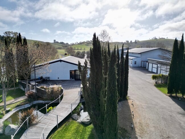


This Property Is For Sale
NEARBY LISTINGS FOR SALE OR LEASE
Property Detail
1020 Penman Springs Rd
015-053-038
Parcel Map Coal 00-0104
Winery
PM 55-31 PAR 2
X
San Luis Obispo
06079C0630H
California
2024
25.48 AC
2025
Outlying SLO County
010302
San Luis Obispo/Paso Robles
7,407 SF
San Luis Obispo-Paso Robles-Arroyo Grande, CA
DEMOGRAPHICS near 1020 Penman Springs Rd
1 Mile
3 Mile
5 Mile
2024 Total Population
75
11,914
36,389
2029 Population
73
11,784
36,126
Pop Growth 2024-2029
(2.67%)
(1.09%)
(0.72%)
Average Age
44
41
40
2024 Total Households
28
4,259
13,288
HH Growth 2024-2029
(3.57%)
(1.36%)
(0.96%)
Median Household Inc
$137,500
$82,603
$84,882
Avg Household Size
2.60
2.70
2.70
2024 Avg HH Vehicles
3.00
2.00
2.00
Median Home Value
$720,588
$536,504
$628,253
Median Year Built
1987
1986
1987
Nearby Places
Map Layers
Map Styles
 Street
 Aerial
- Restaurants
- Banks
- Shops
- Fitness
- Groceries
PUBLIC TRANSPORTATION
COMMUTER RAIL
Paso Robles Amtrak Station (Coast Starlight - Amtrak)
DRIVE
WALK
Distance
Paso Robles Amtrak Station (Coast Starlight - Amtrak)
13 min
6.2 mi
AIRPORT
San Luis County Regional
DRIVE
WALK
Distance
San Luis County Regional
56 min
40.4 mi
Freight Ports
The Port of Hueneme
DRIVE
WALK
Distance
The Port of Hueneme
213 min
167.5 mi
Nearby Properties
Address
Land Use
TOTAL SIZE
Lot Size
Zoning
Address
Land Use
TOTAL SIZE
Lot Size
Zoning
115,054 SF
18.78 AC
PM
Address
Land Use
TOTAL SIZE
Lot Size
Zoning
282,906 SF
10 AC
R4
Address
Land Use
TOTAL SIZE
Lot Size
Zoning
77,710 SF
44 AC
AG
Address
Land Use
TOTAL SIZE
Lot Size
Zoning
330,848 SF
30.24 AC
R315
Address
Land Use
TOTAL SIZE
Lot Size
Zoning
24.74 AC
AG
Address
Land Use
TOTAL SIZE
Lot Size
Zoning
34.76 AC
Address
Land Use
TOTAL SIZE
Lot Size
Zoning
Address
Land Use
TOTAL SIZE
Lot Size
Zoning
3.01 AC
Address
Land Use
TOTAL SIZE
Lot Size
Zoning
14,995 SF
10.74 AC
Address
Land Use
TOTAL SIZE
Lot Size
Zoning
74,710 SF
7.79 AC
R3
Address
Land Use
TOTAL SIZE
Lot Size
Zoning
14.75 AC
Address
Land Use
TOTAL SIZE
Lot Size
Zoning
32,698 SF
3.45 AC
R1
Address
Land Use
TOTAL SIZE
Lot Size
Zoning
11.27 AC
PM
Address
Land Use
TOTAL SIZE
Lot Size
Zoning
1,584 SF
255.80 AC
AG
Address
Land Use
TOTAL SIZE
Lot Size
Zoning
3,650 SF
17.40 AC
R1
Address
Land Use
TOTAL SIZE
Lot Size
Zoning
31,458 SF
3.99 AC
PM
Address
Land Use
TOTAL SIZE
Lot Size
Zoning
6,025 SF
224.27 AC
POS
Address
Land Use
TOTAL SIZE
Lot Size
Zoning
201.46 AC
Address
Land Use
TOTAL SIZE
Lot Size
Zoning
1.10 AC
Address
Land Use
TOTAL SIZE
Lot Size
Zoning
57,434 SF
4.18 AC
R4
Address
Land Use
TOTAL SIZE
Lot Size
Zoning
97,720 SF
9.27 AC
COM
Address
Land Use
TOTAL SIZE
Lot Size
Zoning
4.90 AC
C3
Address
Land Use
TOTAL SIZE
Lot Size
Zoning
40,117 SF
7.49 AC
C1
Address
Land Use
TOTAL SIZE
Lot Size
Zoning
172.19 AC
AG
Address
Land Use
TOTAL SIZE
Lot Size
Zoning
29,800 SF
11.48 AC
C3
Address
Land Use
TOTAL SIZE
Lot Size
Zoning
9.80 AC
Address
Land Use
TOTAL SIZE
Lot Size
Zoning
3.81 AC
C3
Address
Land Use
TOTAL SIZE
Lot Size
Zoning
12,639 SF
8.26 AC
C2
Address
Land Use
TOTAL SIZE
Lot Size
Zoning
1,008 SF
224.50 AC
POS
Address
Land Use
TOTAL SIZE
Lot Size
Zoning
159 AC
AG
The World's #1 Commercial Real Estate Marketplace
Connect with us
© 2025 CoStar Group
The information above has been obtained from sources believed reliable. While we do not doubt its accuracy we have not verified it and make no guarantee, warranty or representation about it. It is your responsibility to independently confirm its accuracy and completeness. Any projections, opinions, assumptions, or estimates used are for example only and do not represent the current or future performance of the property. The value of this transaction to you depends on tax and other factors which should be evaluated by your tax, financial, and legal advisors. You and your advisors should conduct a careful, independent investigation of the property to determine to your satisfaction the suitability of the property for your needs.