Property Record
1020 S Bailey St, Palmer, AK 99645
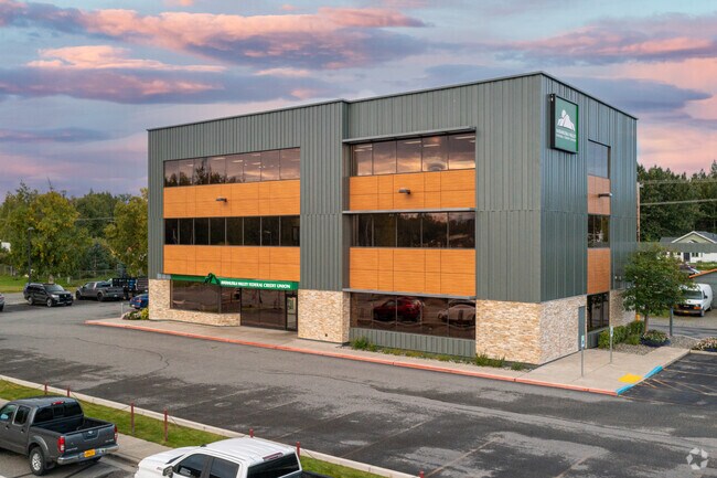

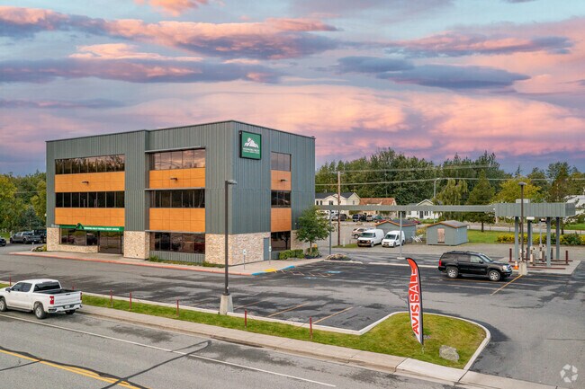
Property Detail
1020 S Bailey St
Anchorage, AK
SNODGRASS M D RSB B/6 L/5B-9B BLOCK 6 LOT 5C
2691B06L005C
Matanuska Susitna
Financialbuilding
Alaska
12
5c
B and X Area of moderate flood hazard, usually the area between the limits of the 100-year and 500-year floods.
0.83 AC
2024
Mat-Su Business Region
2025
Anchorage
001202
NEARBY LISTINGS FOR SALE OR LEASE
-
-
View all Palmer listings for sale on LoopNet.com
DEMOGRAPHICS near 1020 S Bailey St
1 mile
3 mile
5 mile
2025 Total Population
5,984
15,292
24,541
2030 Population
6,509
16,483
26,361
Pop Growth 2025-2030
+ 8.77%
+ 7.79%
+ 7.42%
Average Age
38
38
38
2025 Total Households
2,175
5,489
8,667
HH Growth 2025-2030
+ 9.06%
+ 7.94%
+ 7.52%
Median Household Inc
$79,401
$91,429
$99,939
Avg Household Size
2.50
2.70
2.70
2025 Avg HH Vehicles
2.00
2.00
2.00
Median Home Value
$319,589
$337,159
$357,572
Median Year Built
2001
2000
1999
Nearby Places
Map Layers
Map Styles
 Street
 Aerial
Layers
 Traffic
 Biking
Places
Listings with unknown addresses are not visible on the map
- Restaurants
- Banks
- Shops
- Fitness
- Groceries
PUBLIC TRANSPORTATION
AIRPORT
Merrill Field
Drive
Walk
Distance
Merrill Field
53 min
41.1 mi
Ted Stevens Anchorage International
Drive
Walk
Distance
Ted Stevens Anchorage International
65 min
48.8 mi
Freight Ports
Port of Anchorage
Drive
Walk
Distance
Port of Anchorage
59 min
43.9 mi
Nearby Properties
Address
Land Use
TOTAL SIZE
Lot Size
Zoning
Address
Land Use
TOTAL SIZE
Lot Size
Zoning
42.43 AC
12
Address
Land Use
TOTAL SIZE
Lot Size
Zoning
18.90 AC
12
Address
Land Use
TOTAL SIZE
Lot Size
Zoning
147,377 SF
11.01 AC
12
Address
Land Use
TOTAL SIZE
Lot Size
Zoning
19.49 AC
3
Address
Land Use
TOTAL SIZE
Lot Size
Zoning
27.33 AC
12
Address
Land Use
TOTAL SIZE
Lot Size
Zoning
9.92 AC
12
Address
Land Use
TOTAL SIZE
Lot Size
Zoning
5.99 AC
12
Address
Land Use
TOTAL SIZE
Lot Size
Zoning
80 AC
3
Address
Land Use
TOTAL SIZE
Lot Size
Zoning
13.82 AC
12
Address
Land Use
TOTAL SIZE
Lot Size
Zoning
57,731 SF
7.21 AC
12
Address
Land Use
TOTAL SIZE
Lot Size
Zoning
720 SF
3.57 AC
12
Address
Land Use
TOTAL SIZE
Lot Size
Zoning
20 AC
12
Address
Land Use
TOTAL SIZE
Lot Size
Zoning
10 AC
12
Address
Land Use
TOTAL SIZE
Lot Size
Zoning
21.13 AC
12
Address
Land Use
TOTAL SIZE
Lot Size
Zoning
14.70 AC
12
Address
Land Use
TOTAL SIZE
Lot Size
Zoning
7.05 AC
12
Address
Land Use
TOTAL SIZE
Lot Size
Zoning
2,400 SF
1.52 AC
12
Address
Land Use
TOTAL SIZE
Lot Size
Zoning
7,126 SF
10.28 AC
12
Address
Land Use
TOTAL SIZE
Lot Size
Zoning
62,447 SF
9.70 AC
12
Address
Land Use
TOTAL SIZE
Lot Size
Zoning
14,000 SF
14.46 AC
3
Address
Land Use
TOTAL SIZE
Lot Size
Zoning
16.14 AC
12
Address
Land Use
TOTAL SIZE
Lot Size
Zoning
6.84 AC
12
Address
Land Use
TOTAL SIZE
Lot Size
Zoning
2.01 AC
3
Address
Land Use
TOTAL SIZE
Lot Size
Zoning
16,576 SF
9 AC
12
Address
Land Use
TOTAL SIZE
Lot Size
Zoning
3,154 SF
206.32 AC
12
Address
Land Use
TOTAL SIZE
Lot Size
Zoning
2.29 AC
12
Address
Land Use
TOTAL SIZE
Lot Size
Zoning
7,680 SF
1.86 AC
12
Address
Land Use
TOTAL SIZE
Lot Size
Zoning
3 AC
12
Address
Land Use
TOTAL SIZE
Lot Size
Zoning
27,364 SF
1.30 AC
12
Address
Land Use
TOTAL SIZE
Lot Size
Zoning
3.31 AC
12
The World's #1 Commercial Real Estate Marketplace
Connect with us
© 2026 CoStar Group
The information above has been obtained from sources believed reliable. While we do not doubt its accuracy we have not verified it and make no guarantee, warranty or representation about it. It is your responsibility to independently confirm its accuracy and completeness. Any projections, opinions, assumptions, or estimates used are for example only and do not represent the current or future performance of the property. The value of this transaction to you depends on tax and other factors which should be evaluated by your tax, financial, and legal advisors. You and your advisors should conduct a careful, independent investigation of the property to determine to your satisfaction the suitability of the property for your needs.