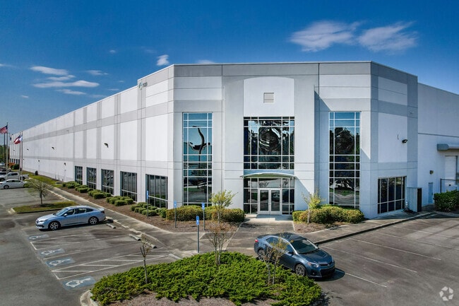
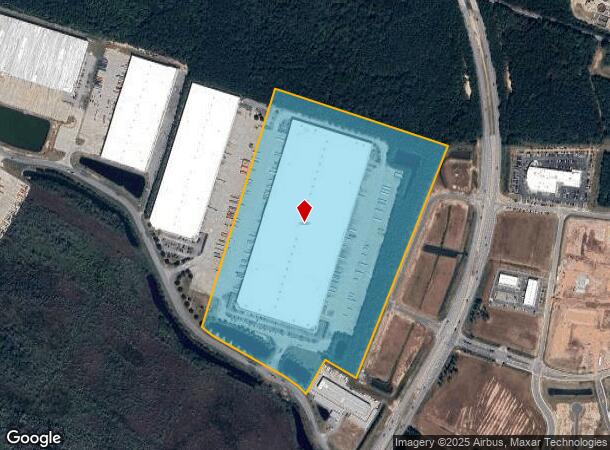
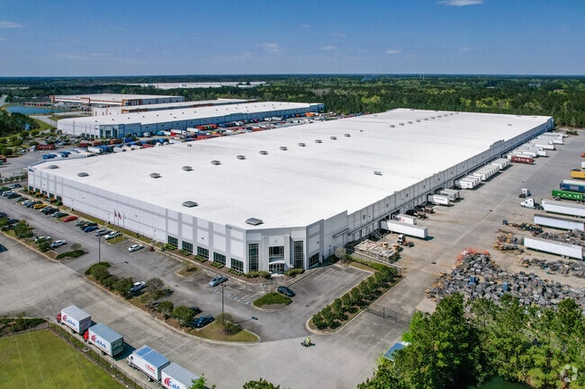
Property Record
1020 Sh Morgan Pky, Pooler, GA 31322

NEARBY LISTINGS FOR SALE OR LEASE
Property Detail
1020 Sh Morgan Pky
Savannah, GA
Sub
5101101047
LOT 4A SUB OF LT 4 MORGAN CENTER SMB 39S 77 44.98AC PRB 39
Warehouse
Chatham
X
Georgia
13051C0107H
4a
2023
44.98 AC
2025
Bloomingdale/Pooler
010811
Savannah
710,881 SF
DEMOGRAPHICS near 1020 Sh Morgan Pky
1 Mile
3 Mile
5 Mile
2024 Total Population
1,909
25,071
47,096
2029 Population
2,021
26,163
49,469
Pop Growth 2024-2029
+ 5.87%
+ 4.36%
+ 5.04%
Average Age
38
40
39
2024 Total Households
747
10,176
18,432
HH Growth 2024-2029
+ 5.76%
+ 4.36%
+ 5.00%
Median Household Inc
$63,353
$80,800
$85,720
Avg Household Size
2.50
2.40
2.50
2024 Avg HH Vehicles
2.00
2.00
2.00
Median Home Value
$197,142
$241,671
$246,226
Median Year Built
2005
2004
2005
Nearby Places
Map Layers
Map Styles
 Street
 Aerial
- Restaurants
- Banks
- Shops
- Fitness
- Groceries
PUBLIC TRANSPORTATION
AIRPORT
Savannah/Hilton Head International
DRIVE
WALK
Distance
Savannah/Hilton Head International
19 min
8.6 mi
Freight Ports
Georgia Ports - Savannah
DRIVE
WALK
Distance
Georgia Ports - Savannah
21 min
10.7 mi
Nearby Properties
Address
Land Use
TOTAL SIZE
Lot Size
Zoning
Address
Land Use
TOTAL SIZE
Lot Size
Zoning
1,080,000 SF
71.17 AC
PUD
Address
Land Use
TOTAL SIZE
Lot Size
Zoning
1,460,340 SF
89.96 AC
RA-1
Address
Land Use
TOTAL SIZE
Lot Size
Zoning
1,193,920 SF
84.08 AC
PUD
Address
Land Use
TOTAL SIZE
Lot Size
Zoning
707,608 SF
78.02 AC
PUD
Address
Land Use
TOTAL SIZE
Lot Size
Zoning
42,338 SF
65.96 AC
PUD
Address
Land Use
TOTAL SIZE
Lot Size
Zoning
944,260 SF
56.31 AC
I-1
Address
Land Use
TOTAL SIZE
Lot Size
Zoning
4,656 SF
80.38 AC
PUD
Address
Land Use
TOTAL SIZE
Lot Size
Zoning
683,796 SF
57.50 AC
PUD
Address
Land Use
TOTAL SIZE
Lot Size
Zoning
4,800 SF
35.20 AC
I-1
Address
Land Use
TOTAL SIZE
Lot Size
Zoning
547,528 SF
67.26 AC
I-1
Address
Land Use
TOTAL SIZE
Lot Size
Zoning
109,284 SF
24.54 AC
R-3-B
Address
Land Use
TOTAL SIZE
Lot Size
Zoning
25,358 SF
10.67 AC
PUD
Address
Land Use
TOTAL SIZE
Lot Size
Zoning
234,700 SF
52.22 AC
PUD
Address
Land Use
TOTAL SIZE
Lot Size
Zoning
17,406 SF
18.27 AC
R-3C
Address
Land Use
TOTAL SIZE
Lot Size
Zoning
27,000 SF
15.11 AC
PUD
Address
Land Use
TOTAL SIZE
Lot Size
Zoning
499,500 SF
28.53 AC
Address
Land Use
TOTAL SIZE
Lot Size
Zoning
35,352 SF
21.22 AC
PUD
Address
Land Use
TOTAL SIZE
Lot Size
Zoning
33.46 AC
PUD
Address
Land Use
TOTAL SIZE
Lot Size
Zoning
985.60 AC
I-2
Address
Land Use
TOTAL SIZE
Lot Size
Zoning
33.42 AC
PUD
Address
Land Use
TOTAL SIZE
Lot Size
Zoning
35,130 SF
21.45 AC
PUD
Address
Land Use
TOTAL SIZE
Lot Size
Zoning
34,404 SF
20 AC
C2
Address
Land Use
TOTAL SIZE
Lot Size
Zoning
39,720 SF
16.18 AC
PUD
Address
Land Use
TOTAL SIZE
Lot Size
Zoning
15,804 SF
17 AC
R3
Address
Land Use
TOTAL SIZE
Lot Size
Zoning
41,172 SF
29.69 AC
PUD
Address
Land Use
TOTAL SIZE
Lot Size
Zoning
8,464 SF
32.62 AC
RA1
Address
Land Use
TOTAL SIZE
Lot Size
Zoning
521,740 SF
230.25 AC
I-1
Address
Land Use
TOTAL SIZE
Lot Size
Zoning
290,524 SF
21.52 AC
Address
Land Use
TOTAL SIZE
Lot Size
Zoning
345,600 SF
22.22 AC
PUD
The World's #1 Commercial Real Estate Marketplace
Connect with us
© 2026 CoStar Group
The information above has been obtained from sources believed reliable. While we do not doubt its accuracy we have not verified it and make no guarantee, warranty or representation about it. It is your responsibility to independently confirm its accuracy and completeness. Any projections, opinions, assumptions, or estimates used are for example only and do not represent the current or future performance of the property. The value of this transaction to you depends on tax and other factors which should be evaluated by your tax, financial, and legal advisors. You and your advisors should conduct a careful, independent investigation of the property to determine to your satisfaction the suitability of the property for your needs.