Property Record
1020 State Highway 195, Georgetown, TX 78633

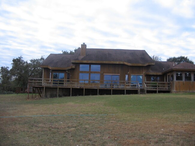
Property Detail
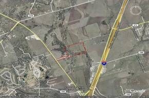
1020 State Highway 195
Austin-Round Rock-San Marcos, TX
AW0524 AW0524 - ROBERTS, WM. SUR., ACRES 53.211
R327449
Williamson
Agriculturalland
Texas
A Areas with a 1% annual chance of flooding and a 26% chance of flooding over the life of a 30-year mortgage.
53.21 AC
2024
Georgetown
2025
Austin
021603
NEARBY LISTINGS FOR SALE OR LEASE
-
-
-
-
-
-
-
-
-
-
-
-
-
-
-
-
-
-
-
-
No Photo
-
View all Georgetown listings for sale on LoopNet.com
DEMOGRAPHICS near 1020 State Highway 195
1 mile
3 mile
5 mile
2024 Total Population
1,465
12,316
53,511
2029 Population
1,712
13,996
61,315
Pop Growth 2024-2029
+ 16.86%
+ 13.64%
+ 14.58%
Average Age
44
50
49
2024 Total Households
576
5,131
23,650
HH Growth 2024-2029
+ 17.36%
+ 13.90%
+ 14.90%
Median Household Inc
$114,399
$110,799
$96,161
Avg Household Size
2.50
2.40
2.20
2024 Avg HH Vehicles
2.00
2.00
2.00
Median Home Value
$465,577
$494,488
$462,461
Median Year Built
2010
2001
2004
Nearby Places
Map Layers
Map Styles
 Street
 Aerial
Transit
 Traffic
 Biking
Places
Listings with unknown addresses are not visible on the map
- Restaurants
- Banks
- Shops
- Fitness
- Groceries
PUBLIC TRANSPORTATION
AIRPORT
Killeen Municipal
Drive
Walk
Distance
Killeen Municipal
46 min
35.8 mi
Robert Gray AAF
Drive
Walk
Distance
Robert Gray AAF
50 min
36.6 mi
Freight Ports
Calhoun Port
Drive
Walk
Distance
Calhoun Port
214 min
188.9 mi
Nearby Properties
Address
Land Use
TOTAL SIZE
Lot Size
Zoning
Address
Land Use
TOTAL SIZE
Lot Size
Zoning
200,200 SF
34.02 AC
Address
Land Use
TOTAL SIZE
Lot Size
Zoning
326,646 SF
19.33 AC
Address
Land Use
TOTAL SIZE
Lot Size
Zoning
425,144 SF
32.97 AC
Address
Land Use
TOTAL SIZE
Lot Size
Zoning
439,044 SF
32.68 AC
Address
Land Use
TOTAL SIZE
Lot Size
Zoning
495,945 SF
56.14 AC
Address
Land Use
TOTAL SIZE
Lot Size
Zoning
520,121 SF
56.73 AC
Address
Land Use
TOTAL SIZE
Lot Size
Zoning
193,985 SF
38.17 AC
Address
Land Use
TOTAL SIZE
Lot Size
Zoning
298,302 SF
20.96 AC
Address
Land Use
TOTAL SIZE
Lot Size
Zoning
241,857 SF
26.60 AC
Address
Land Use
TOTAL SIZE
Lot Size
Zoning
200,746 SF
17.52 AC
Address
Land Use
TOTAL SIZE
Lot Size
Zoning
154,603 SF
20.04 AC
Address
Land Use
TOTAL SIZE
Lot Size
Zoning
172,657 SF
8.84 AC
Address
Land Use
TOTAL SIZE
Lot Size
Zoning
174,955 SF
9.28 AC
Address
Land Use
TOTAL SIZE
Lot Size
Zoning
162,236 SF
8.99 AC
Address
Land Use
TOTAL SIZE
Lot Size
Zoning
90,821 SF
41.97 AC
Address
Land Use
TOTAL SIZE
Lot Size
Zoning
160,042 SF
10.15 AC
Address
Land Use
TOTAL SIZE
Lot Size
Zoning
184,242 SF
11 AC
Address
Land Use
TOTAL SIZE
Lot Size
Zoning
219,839 SF
24.74 AC
Address
Land Use
TOTAL SIZE
Lot Size
Zoning
22,936 SF
111.18 AC
Address
Land Use
TOTAL SIZE
Lot Size
Zoning
150,808 SF
7.72 AC
2-I
Address
Land Use
TOTAL SIZE
Lot Size
Zoning
100,956 SF
5.32 AC
Address
Land Use
TOTAL SIZE
Lot Size
Zoning
124,292 SF
8.67 AC
Address
Land Use
TOTAL SIZE
Lot Size
Zoning
70,873 SF
5.88 AC
Address
Land Use
TOTAL SIZE
Lot Size
Zoning
62,452 SF
11 AC
Address
Land Use
TOTAL SIZE
Lot Size
Zoning
57,600 SF
4.12 AC
Address
Land Use
TOTAL SIZE
Lot Size
Zoning
39,020 SF
11.65 AC
Address
Land Use
TOTAL SIZE
Lot Size
Zoning
57,600 SF
7.20 AC
Address
Land Use
TOTAL SIZE
Lot Size
Zoning
58,763 SF
4.24 AC
2-I
Address
Land Use
TOTAL SIZE
Lot Size
Zoning
84,960 SF
5.12 AC
Address
Land Use
TOTAL SIZE
Lot Size
Zoning
149,694 SF
72.61 AC
2-I
The World's #1 Commercial Real Estate Marketplace
Connect with us
© 2026 CoStar Group
The information above has been obtained from sources believed reliable. While we do not doubt its accuracy we have not verified it and make no guarantee, warranty or representation about it. It is your responsibility to independently confirm its accuracy and completeness. Any projections, opinions, assumptions, or estimates used are for example only and do not represent the current or future performance of the property. The value of this transaction to you depends on tax and other factors which should be evaluated by your tax, financial, and legal advisors. You and your advisors should conduct a careful, independent investigation of the property to determine to your satisfaction the suitability of the property for your needs.