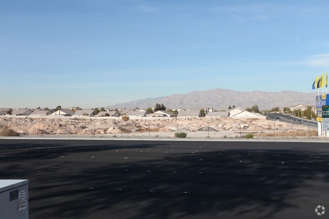
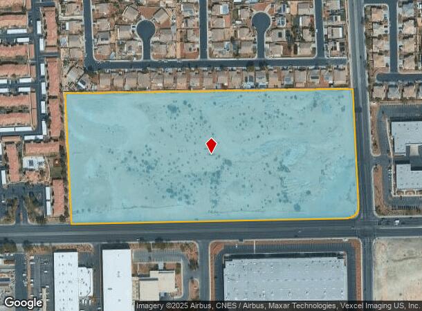
Property Record
1020 W Cheyenne Ave, North Las Vegas, NV 89032


NEARBY LISTINGS FOR SALE OR LEASE
Property Detail
1020 W Cheyenne Ave
139-09-801-005
PT SE4 SE4 SEC 09 20 61
Vacantlandnec
Clark
X
Nevada
32003C2160F
17.34 AC
2025
North Las Vegas
2025
Las Vegas
003613
Las Vegas-Henderson-Paradise, NV
DEMOGRAPHICS near 1020 W Cheyenne Ave
1 Mile
3 Mile
5 Mile
2024 Total Population
16,353
165,228
498,419
2029 Population
17,460
177,034
534,816
Pop Growth 2024-2029
+ 6.77%
+ 7.15%
+ 7.30%
Average Age
36
36
36
2024 Total Households
5,102
50,975
165,293
HH Growth 2024-2029
+ 6.72%
+ 7.20%
+ 7.31%
Median Household Inc
$62,679
$51,026
$51,548
Avg Household Size
3.10
3.10
2.90
2024 Avg HH Vehicles
2.00
2.00
2.00
Median Home Value
$270,609
$279,510
$297,721
Median Year Built
1997
1994
1992
Nearby Places
Map Layers
Map Styles
 Street
 Aerial
- Restaurants
- Banks
- Shops
- Fitness
- Groceries
PUBLIC TRANSPORTATION
AIRPORT
Harry Reid International
DRIVE
WALK
Distance
Harry Reid International
21 min
11.4 mi
Boulder City Municipal
DRIVE
WALK
Distance
Boulder City Municipal
40 min
30.0 mi
Freight Ports
Port of Long Beach
DRIVE
WALK
Distance
Port of Long Beach
322 min
286.9 mi
SALE & LEASE HISTORY
LISTING DATE
SALE/LEASE

Sep 24, 2016
For Sale
Nearby Properties
Address
Land Use
TOTAL SIZE
Lot Size
Zoning
Address
Land Use
TOTAL SIZE
Lot Size
Zoning
1,767,948 SF
142.04 AC
Address
Land Use
TOTAL SIZE
Lot Size
Zoning
34.83 AC
CV
Address
Land Use
TOTAL SIZE
Lot Size
Zoning
252,005 SF
27.94 AC
C3
Address
Land Use
TOTAL SIZE
Lot Size
Zoning
724,845 SF
37.33 AC
M2
Address
Land Use
TOTAL SIZE
Lot Size
Zoning
9,738 SF
20.40 AC
Address
Land Use
TOTAL SIZE
Lot Size
Zoning
51.45 AC
R1
Address
Land Use
TOTAL SIZE
Lot Size
Zoning
324 SF
8.74 AC
R1
Address
Land Use
TOTAL SIZE
Lot Size
Zoning
617,670 SF
27.90 AC
M2
Address
Land Use
TOTAL SIZE
Lot Size
Zoning
7,724 SF
108.84 AC
R1
Address
Land Use
TOTAL SIZE
Lot Size
Zoning
1,608 SF
30.32 AC
RAPSP
Address
Land Use
TOTAL SIZE
Lot Size
Zoning
35.49 AC
RE
Address
Land Use
TOTAL SIZE
Lot Size
Zoning
191,879 SF
12 AC
RACHE
Address
Land Use
TOTAL SIZE
Lot Size
Zoning
35.49 AC
R1
Address
Land Use
TOTAL SIZE
Lot Size
Zoning
390,851 SF
48.43 AC
PUD
Address
Land Use
TOTAL SIZE
Lot Size
Zoning
504,501 SF
23.08 AC
M2
Address
Land Use
TOTAL SIZE
Lot Size
Zoning
36.24 AC
M2
Address
Land Use
TOTAL SIZE
Lot Size
Zoning
513,240 SF
24.86 AC
M2
Address
Land Use
TOTAL SIZE
Lot Size
Zoning
22.77 AC
CV
Address
Land Use
TOTAL SIZE
Lot Size
Zoning
346,277 SF
37.61 AC
PUD
Address
Land Use
TOTAL SIZE
Lot Size
Zoning
355,910 SF
18.87 AC
M2
Address
Land Use
TOTAL SIZE
Lot Size
Zoning
378,212 SF
6.38 AC
Address
Land Use
TOTAL SIZE
Lot Size
Zoning
612,680 SF
25.48 AC
M2
Address
Land Use
TOTAL SIZE
Lot Size
Zoning
3,518 SF
11.95 AC
Address
Land Use
TOTAL SIZE
Lot Size
Zoning
407,991 SF
26.52 AC
M2
Address
Land Use
TOTAL SIZE
Lot Size
Zoning
445,206 SF
24.81 AC
M2
Address
Land Use
TOTAL SIZE
Lot Size
Zoning
34,765 SF
16.85 AC
M2
Address
Land Use
TOTAL SIZE
Lot Size
Zoning
7,704 SF
22.18 AC
N:PUD
The World's #1 Commercial Real Estate Marketplace
Connect with us
© 2025 CoStar Group
The information above has been obtained from sources believed reliable. While we do not doubt its accuracy we have not verified it and make no guarantee, warranty or representation about it. It is your responsibility to independently confirm its accuracy and completeness. Any projections, opinions, assumptions, or estimates used are for example only and do not represent the current or future performance of the property. The value of this transaction to you depends on tax and other factors which should be evaluated by your tax, financial, and legal advisors. You and your advisors should conduct a careful, independent investigation of the property to determine to your satisfaction the suitability of the property for your needs.