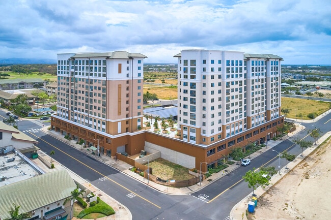
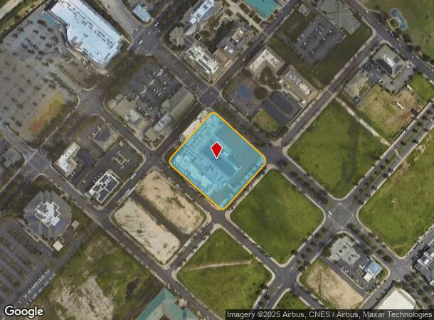
Property Record
1020 Wakea St, Kapolei, HI 96707

Current Lease Availabilities
NEARBY LISTINGS FOR SALE OR LEASE
Property Detail
1020 Wakea St
1-9-1-088-021-0000
LOT 16538 MAP 1290 LCAPP 1069 3.036 AC SUBJ/E 8841 & 8842 FOR LANDSCAPING/UTILITY MAP 1290
Commercialnec
Honolulu
D
Hawaii
15003C0310G
16538
0
3.04 AC
2025
West Oahu
011500
Hawaii
14,728 SF
Urban Honolulu, HI
DEMOGRAPHICS near 1020 Wakea St
1 Mile
3 Mile
5 Mile
2024 Total Population
12,816
49,222
104,392
2029 Population
12,534
47,528
99,911
Pop Growth 2024-2029
(2.20%)
(3.44%)
(4.29%)
Average Age
36
37
37
2024 Total Households
3,903
14,561
29,823
HH Growth 2024-2029
(2.38%)
(3.97%)
(4.76%)
Median Household Inc
$113,942
$113,418
$113,772
Avg Household Size
3.00
3.20
3.30
2024 Avg HH Vehicles
2.00
2.00
2.00
Median Home Value
$713,392
$735,047
$723,835
Median Year Built
2010
1999
1999
Nearby Places
- Restaurants
- Banks
- Shops
- Fitness
- Groceries
PUBLIC TRANSPORTATION
AIRPORT
Daniel K Inouye International
DRIVE
WALK
Distance
Daniel K Inouye International
24 min
17.3 mi
Freight Ports
Honolulu Harbor, Oahu
DRIVE
WALK
Distance
Honolulu Harbor, Oahu
1 min
13.8 mi
Nearby Properties
Address
Land Use
TOTAL SIZE
Lot Size
Zoning
Address
Land Use
TOTAL SIZE
Lot Size
Zoning
1,193,532 SF
9.53 AC
Resort
Address
Land Use
TOTAL SIZE
Lot Size
Zoning
736 AC
F-1
Address
Land Use
TOTAL SIZE
Lot Size
Zoning
1,963,629 SF
10.70 AC
Resort
Address
Land Use
TOTAL SIZE
Lot Size
Zoning
310,432 SF
192.56 AC
BMX-3
Address
Land Use
TOTAL SIZE
Lot Size
Zoning
288,660 SF
10.94 AC
A-2
Address
Land Use
TOTAL SIZE
Lot Size
Zoning
645,869 SF
48.95 AC
AG-1
Address
Land Use
TOTAL SIZE
Lot Size
Zoning
447,096 SF
9.98 AC
A-2
Address
Land Use
TOTAL SIZE
Lot Size
Zoning
294,056 SF
11.69 AC
Resort
Address
Land Use
TOTAL SIZE
Lot Size
Zoning
80,641 SF
227.76 AC
I-2
Address
Land Use
TOTAL SIZE
Lot Size
Zoning
222.44 AC
I-3
Address
Land Use
TOTAL SIZE
Lot Size
Zoning
139.30 AC
F-1
Address
Land Use
TOTAL SIZE
Lot Size
Zoning
222.34 AC
I-3
Address
Land Use
TOTAL SIZE
Lot Size
Zoning
48.66 AC
I-2
Address
Land Use
TOTAL SIZE
Lot Size
Zoning
10 AC
Resort
Address
Land Use
TOTAL SIZE
Lot Size
Zoning
14.70 AC
Resort
Address
Land Use
TOTAL SIZE
Lot Size
Zoning
61,643 SF
116.66 AC
I-2
Address
Land Use
TOTAL SIZE
Lot Size
Zoning
307,171 SF
24.64 AC
I-2
Address
Land Use
TOTAL SIZE
Lot Size
Zoning
229,396 SF
11.31 AC
BMX-3
Address
Land Use
TOTAL SIZE
Lot Size
Zoning
2,225 SF
19.72 AC
AG-1
Address
Land Use
TOTAL SIZE
Lot Size
Zoning
10,182 SF
10.30 AC
Resort
Address
Land Use
TOTAL SIZE
Lot Size
Zoning
46.69 AC
B-2
Address
Land Use
TOTAL SIZE
Lot Size
Zoning
334.93 AC
U/42/40
Address
Land Use
TOTAL SIZE
Lot Size
Zoning
7.22 AC
Resort
Address
Land Use
TOTAL SIZE
Lot Size
Zoning
222,228 SF
7.15 AC
B-2
Address
Land Use
TOTAL SIZE
Lot Size
Zoning
183,343 SF
15.27 AC
BMX-3
Address
Land Use
TOTAL SIZE
Lot Size
Zoning
149,923 SF
13.35 AC
B-2
Address
Land Use
TOTAL SIZE
Lot Size
Zoning
19.38 AC
A-2
Address
Land Use
TOTAL SIZE
Lot Size
Zoning
67.18 AC
AG-1
Address
Land Use
TOTAL SIZE
Lot Size
Zoning
45.60 AC
F-1
The World's #1 Commercial Real Estate Marketplace
Connect with us
© 2025 CoStar Group
The information above has been obtained from sources believed reliable. While we do not doubt its accuracy we have not verified it and make no guarantee, warranty or representation about it. It is your responsibility to independently confirm its accuracy and completeness. Any projections, opinions, assumptions, or estimates used are for example only and do not represent the current or future performance of the property. The value of this transaction to you depends on tax and other factors which should be evaluated by your tax, financial, and legal advisors. You and your advisors should conduct a careful, independent investigation of the property to determine to your satisfaction the suitability of the property for your needs.