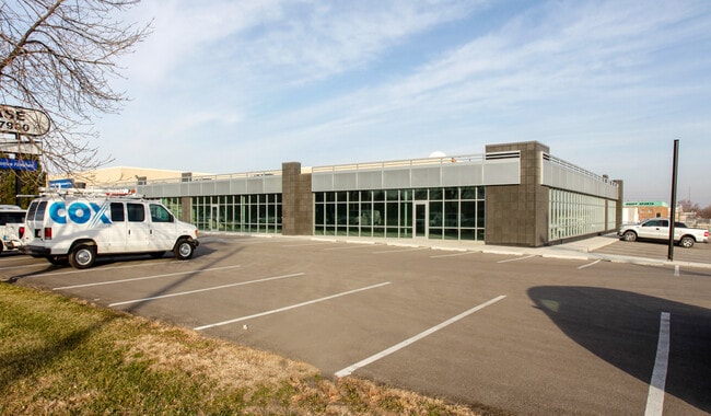
Property Record
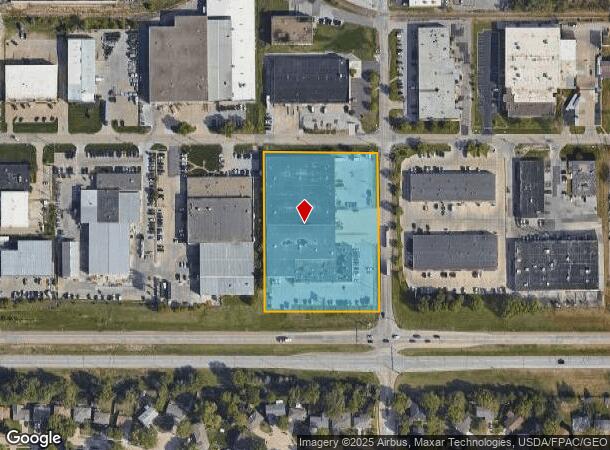
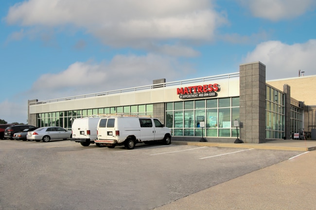
10200 L St, Omaha, NE 68127
Current Lease Availabilities
NEARBY LISTINGS FOR SALE OR LEASE
Property Detail
10200 L St
2528-0005-01
Lands
Warehouse
LANDS SEC-TWN-RGE 04-14-12 N 470 S 560 W 337 E 367 FT SE 1/4 NW 1/4 3.64 AC
X
Douglas
31153C0055H
Nebraska
2024
3.64 AC
2025
South Central Omaha
007467
Omaha/Council Bluffs
79,364 SF
Omaha-Council Bluffs, NE-IA
DEMOGRAPHICS near 10200 L St
1 Mile
3 Mile
5 Mile
2024 Total Population
8,989
83,915
222,049
2029 Population
9,066
86,080
228,029
Pop Growth 2024-2029
+ 0.86%
+ 2.58%
+ 2.69%
Average Age
38
40
39
2024 Total Households
4,200
36,096
93,299
HH Growth 2024-2029
+ 0.81%
+ 2.57%
+ 2.66%
Median Household Inc
$56,480
$68,211
$71,490
Avg Household Size
2.10
2.30
2.30
2024 Avg HH Vehicles
2.00
2.00
2.00
Median Home Value
$197,480
$232,285
$225,627
Median Year Built
1975
1975
1976
Nearby Places
- Restaurants
- Banks
- Shops
- Fitness
- Groceries
PUBLIC TRANSPORTATION
COMMUTER RAIL
DRIVE
WALK
Distance
16 min
9.9 mi
AIRPORT
Eppley Airfield
DRIVE
WALK
Distance
Eppley Airfield
25 min
13.9 mi
Nearby Properties
Address
Land Use
TOTAL SIZE
Lot Size
Zoning
Address
Land Use
TOTAL SIZE
Lot Size
Zoning
341,667 SF
24.15 AC
Address
Land Use
TOTAL SIZE
Lot Size
Zoning
370,890 SF
11.20 AC
CC
Address
Land Use
TOTAL SIZE
Lot Size
Zoning
503,886 SF
25.40 AC
Address
Land Use
TOTAL SIZE
Lot Size
Zoning
599,779 SF
46.87 AC
I1
Address
Land Use
TOTAL SIZE
Lot Size
Zoning
398,593 SF
10.80 AC
Address
Land Use
TOTAL SIZE
Lot Size
Zoning
252,985 SF
6.53 AC
Address
Land Use
TOTAL SIZE
Lot Size
Zoning
317,277 SF
20.12 AC
Address
Land Use
TOTAL SIZE
Lot Size
Zoning
130,286 SF
4.31 AC
GO
Address
Land Use
TOTAL SIZE
Lot Size
Zoning
28,913 SF
2.04 AC
Address
Land Use
TOTAL SIZE
Lot Size
Zoning
96,871 SF
9.98 AC
Address
Land Use
TOTAL SIZE
Lot Size
Zoning
85,632 SF
5.69 AC
Address
Land Use
TOTAL SIZE
Lot Size
Zoning
897,738 SF
52.16 AC
Address
Land Use
TOTAL SIZE
Lot Size
Zoning
23,890 SF
14.34 AC
I2
Address
Land Use
TOTAL SIZE
Lot Size
Zoning
329,515 SF
6.37 AC
Address
Land Use
TOTAL SIZE
Lot Size
Zoning
354,299 SF
22.85 AC
R6
Address
Land Use
TOTAL SIZE
Lot Size
Zoning
423,905 SF
21.96 AC
GI
Address
Land Use
TOTAL SIZE
Lot Size
Zoning
294,672 SF
15.06 AC
Address
Land Use
TOTAL SIZE
Lot Size
Zoning
646,213 SF
37.22 AC
Address
Land Use
TOTAL SIZE
Lot Size
Zoning
354,615 SF
18.13 AC
R6
Address
Land Use
TOTAL SIZE
Lot Size
Zoning
13,930 SF
1.04 AC
Address
Land Use
TOTAL SIZE
Lot Size
Zoning
199,152 SF
13.44 AC
R6
Address
Land Use
TOTAL SIZE
Lot Size
Zoning
271,344 SF
9.78 AC
Address
Land Use
TOTAL SIZE
Lot Size
Zoning
271,404 SF
17.51 AC
Address
Land Use
TOTAL SIZE
Lot Size
Zoning
309,162 SF
15.54 AC
Address
Land Use
TOTAL SIZE
Lot Size
Zoning
234,332 SF
12.30 AC
Address
Land Use
TOTAL SIZE
Lot Size
Zoning
258,637 SF
24.30 AC
Address
Land Use
TOTAL SIZE
Lot Size
Zoning
124,820 SF
9.69 AC
MU
Address
Land Use
TOTAL SIZE
Lot Size
Zoning
2,610 SF
9.96 AC
Address
Land Use
TOTAL SIZE
Lot Size
Zoning
286,445 SF
16.18 AC
R6
Address
Land Use
TOTAL SIZE
Lot Size
Zoning
154,164 SF
13.33 AC
The World's #1 Commercial Real Estate Marketplace
Connect with us
© 2025 CoStar Group
The information above has been obtained from sources believed reliable. While we do not doubt its accuracy we have not verified it and make no guarantee, warranty or representation about it. It is your responsibility to independently confirm its accuracy and completeness. Any projections, opinions, assumptions, or estimates used are for example only and do not represent the current or future performance of the property. The value of this transaction to you depends on tax and other factors which should be evaluated by your tax, financial, and legal advisors. You and your advisors should conduct a careful, independent investigation of the property to determine to your satisfaction the suitability of the property for your needs.