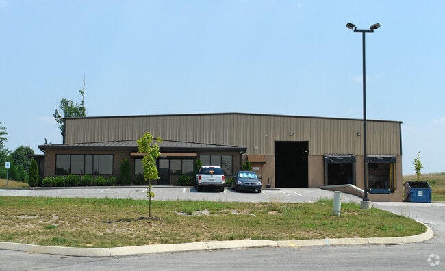
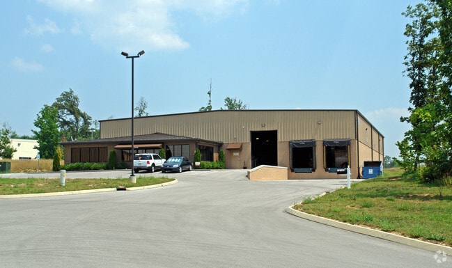
Property Record
10200 Upper Ridge Way, Knoxville, TN 37932


NEARBY LISTINGS FOR SALE OR LEASE
Property Detail
10200 Upper Ridge Way
Knoxville, TN
Cogdill Commercial Park Unit 3 Resub
118OB-00201
SUBDIVISIONNAME COGDILL COMMERCIAL PARK UNIT 3 RESUB MA PPLATB 20050518 MAPPLATP 0092726 DIMENSIONS 102.72 X 46 0 X IRR
Warehouse
Knox
X
Tennessee
47093C0242G
2r1
2025
1.94 AC
2025
Pellissippi/Lovell
005911
Knoxville
15,250 SF
DEMOGRAPHICS near 10200 Upper Ridge Way
1 Mile
3 Mile
5 Mile
2024 Total Population
1,444
44,611
127,281
2029 Population
1,551
48,362
138,264
Pop Growth 2024-2029
+ 7.41%
+ 8.41%
+ 8.63%
Average Age
41
40
40
2024 Total Households
609
18,432
51,423
HH Growth 2024-2029
+ 7.55%
+ 8.53%
+ 8.72%
Median Household Inc
$76,956
$86,536
$89,787
Avg Household Size
2.30
2.40
2.40
2024 Avg HH Vehicles
2.00
2.00
2.00
Median Home Value
$236,893
$315,995
$335,255
Median Year Built
1979
1990
1991
Nearby Places
Map Layers
Map Styles
 Street
 Aerial
- Restaurants
- Banks
- Shops
- Fitness
- Groceries
PUBLIC TRANSPORTATION
AIRPORT
McGhee Tyson
DRIVE
WALK
Distance
McGhee Tyson
23 min
15.6 mi
Freight Ports
Georgia Ports - Savannah
DRIVE
WALK
Distance
Georgia Ports - Savannah
492 min
428.1 mi
SALE & LEASE HISTORY
LISTING DATE
SALE/LEASE

Jan 03, 2025
For Lease
Nearby Properties
Address
Land Use
TOTAL SIZE
Lot Size
Zoning
Address
Land Use
TOTAL SIZE
Lot Size
Zoning
144,557 SF
8.61 AC
Address
Land Use
TOTAL SIZE
Lot Size
Zoning
32,760 SF
19.10 AC
Address
Land Use
TOTAL SIZE
Lot Size
Zoning
6,828 SF
24.88 AC
Address
Land Use
TOTAL SIZE
Lot Size
Zoning
275,625 SF
17.24 AC
Address
Land Use
TOTAL SIZE
Lot Size
Zoning
2,659 SF
60.74 AC
Address
Land Use
TOTAL SIZE
Lot Size
Zoning
17,066 SF
39.06 AC
Address
Land Use
TOTAL SIZE
Lot Size
Zoning
11,200 SF
25.95 AC
Address
Land Use
TOTAL SIZE
Lot Size
Zoning
41,095 SF
26.12 AC
Address
Land Use
TOTAL SIZE
Lot Size
Zoning
3,474 SF
21.24 AC
Address
Land Use
TOTAL SIZE
Lot Size
Zoning
5,815 SF
28.19 AC
Address
Land Use
TOTAL SIZE
Lot Size
Zoning
5,127 SF
12.28 AC
Address
Land Use
TOTAL SIZE
Lot Size
Zoning
25,196 SF
31.91 AC
Address
Land Use
TOTAL SIZE
Lot Size
Zoning
6,224 SF
12.35 AC
Address
Land Use
TOTAL SIZE
Lot Size
Zoning
6,770 SF
20.21 AC
Address
Land Use
TOTAL SIZE
Lot Size
Zoning
3,190 SF
19.64 AC
Address
Land Use
TOTAL SIZE
Lot Size
Zoning
26,880 SF
38.02 AC
Address
Land Use
TOTAL SIZE
Lot Size
Zoning
8,580 SF
8.34 AC
Address
Land Use
TOTAL SIZE
Lot Size
Zoning
102,314 SF
21.55 AC
Address
Land Use
TOTAL SIZE
Lot Size
Zoning
49,524 SF
6.83 AC
Address
Land Use
TOTAL SIZE
Lot Size
Zoning
27,300 SF
10.61 AC
Address
Land Use
TOTAL SIZE
Lot Size
Zoning
143,967 SF
16.81 AC
Address
Land Use
TOTAL SIZE
Lot Size
Zoning
51,016 SF
10.03 AC
Address
Land Use
TOTAL SIZE
Lot Size
Zoning
87,500 SF
7.25 AC
Address
Land Use
TOTAL SIZE
Lot Size
Zoning
32,447 SF
11.46 AC
Address
Land Use
TOTAL SIZE
Lot Size
Zoning
53,654 SF
17.10 AC
Address
Land Use
TOTAL SIZE
Lot Size
Zoning
55,258 SF
8.43 AC
Address
Land Use
TOTAL SIZE
Lot Size
Zoning
39,138 SF
19.78 AC
Address
Land Use
TOTAL SIZE
Lot Size
Zoning
6,344 SF
23.12 AC
Address
Land Use
TOTAL SIZE
Lot Size
Zoning
19,274 SF
15.73 AC
Address
Land Use
TOTAL SIZE
Lot Size
Zoning
87,273 SF
26.39 AC
The World's #1 Commercial Real Estate Marketplace
Connect with us
© 2026 CoStar Group
The information above has been obtained from sources believed reliable. While we do not doubt its accuracy we have not verified it and make no guarantee, warranty or representation about it. It is your responsibility to independently confirm its accuracy and completeness. Any projections, opinions, assumptions, or estimates used are for example only and do not represent the current or future performance of the property. The value of this transaction to you depends on tax and other factors which should be evaluated by your tax, financial, and legal advisors. You and your advisors should conduct a careful, independent investigation of the property to determine to your satisfaction the suitability of the property for your needs.