Property Record
10201 E Valley Rd, Prescott Valley, AZ 86314


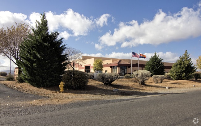
Property Detail
10201 E Valley Rd
402-14-229H
AN IRREG PCL W2NW4 NW COR APPROX 574 FT E & 668 FT S FROM NW COR OF SEC 20-14-1E CONT 13.31AC 3934/516
Shipyard
Yavapai
B and X Area of moderate flood hazard, usually the area between the limits of the 100-year and 500-year floods.
Arizona
2025
13.31 AC
2027
Prescott & Sedona
000617
Other Market Areas
33,196 SF
Prescott, AZ
NEARBY LISTINGS FOR SALE OR LEASE
DEMOGRAPHICS near 10201 E Valley Rd
1 mile
3 mile
5 mile
2025 Total Population
2
24,941
51,340
2030 Population
2
25,814
53,331
Pop Growth 2025-2030
0.00%
+ 3.50%
+ 3.88%
Average Age
0
45
46
2025 Total Households
1
10,564
21,572
HH Growth 2025-2030
0.00%
+ 3.78%
+ 4.08%
Median Household Inc
$0
$65,473
$69,800
Avg Household Size
.00
2.30
2.30
2025 Avg HH Vehicles
.00
2.00
2.00
Median Home Value
$0
$362,647
$398,942
Median Year Built
0
1993
1997
Nearby Places
Map Layers
Map Styles
 Street
 Aerial
Layers
 Traffic
 Biking
Places
Listings with unknown addresses are not visible on the map
- Restaurants
- Banks
- Shops
- Fitness
- Groceries
Nearby Properties
Address
Land Use
TOTAL SIZE
Lot Size
Zoning
Address
Land Use
TOTAL SIZE
Lot Size
Zoning
208,851 SF
27.27 AC
Address
Land Use
TOTAL SIZE
Lot Size
Zoning
905,092 SF
45.06 AC
Address
Land Use
TOTAL SIZE
Lot Size
Zoning
135,064 SF
5.09 AC
Address
Land Use
TOTAL SIZE
Lot Size
Zoning
124,220 SF
2.85 AC
Address
Land Use
TOTAL SIZE
Lot Size
Zoning
80,137 SF
20 AC
Address
Land Use
TOTAL SIZE
Lot Size
Zoning
18,241 SF
66.38 AC
Address
Land Use
TOTAL SIZE
Lot Size
Zoning
265,055 SF
20.24 AC
Address
Land Use
TOTAL SIZE
Lot Size
Zoning
104,615 SF
8.54 AC
Address
Land Use
TOTAL SIZE
Lot Size
Zoning
59,348 SF
10.25 AC
Address
Land Use
TOTAL SIZE
Lot Size
Zoning
59,859 SF
2.05 AC
Address
Land Use
TOTAL SIZE
Lot Size
Zoning
41,251 SF
4.79 AC
Address
Land Use
TOTAL SIZE
Lot Size
Zoning
51,437 SF
5.90 AC
Address
Land Use
TOTAL SIZE
Lot Size
Zoning
52,282 SF
9.44 AC
Address
Land Use
TOTAL SIZE
Lot Size
Zoning
102,281 SF
11.81 AC
Address
Land Use
TOTAL SIZE
Lot Size
Zoning
68,093 SF
4.78 AC
Address
Land Use
TOTAL SIZE
Lot Size
Zoning
54,552 SF
49.31 AC
Address
Land Use
TOTAL SIZE
Lot Size
Zoning
19,609 SF
26.50 AC
Address
Land Use
TOTAL SIZE
Lot Size
Zoning
5,516 SF
42.65 AC
Address
Land Use
TOTAL SIZE
Lot Size
Zoning
41,370 SF
4.94 AC
Address
Land Use
TOTAL SIZE
Lot Size
Zoning
60,659 SF
2.22 AC
Address
Land Use
TOTAL SIZE
Lot Size
Zoning
109,140 SF
7.47 AC
Address
Land Use
TOTAL SIZE
Lot Size
Zoning
67,322 SF
5 AC
Address
Land Use
TOTAL SIZE
Lot Size
Zoning
61,755 SF
10.86 AC
Address
Land Use
TOTAL SIZE
Lot Size
Zoning
45,536 SF
5 AC
Address
Land Use
TOTAL SIZE
Lot Size
Zoning
36,927 SF
2.67 AC
Address
Land Use
TOTAL SIZE
Lot Size
Zoning
50,455 SF
7.11 AC
Address
Land Use
TOTAL SIZE
Lot Size
Zoning
33,622 SF
0.43 AC
Address
Land Use
TOTAL SIZE
Lot Size
Zoning
31,883 SF
0.44 AC
Address
Land Use
TOTAL SIZE
Lot Size
Zoning
29,411 SF
4.25 AC
Address
Land Use
TOTAL SIZE
Lot Size
Zoning
23,000 SF
5.34 AC
The World's #1 Commercial Real Estate Marketplace
Connect with us
© 2026 CoStar Group
The information above has been obtained from sources believed reliable. While we do not doubt its accuracy we have not verified it and make no guarantee, warranty or representation about it. It is your responsibility to independently confirm its accuracy and completeness. Any projections, opinions, assumptions, or estimates used are for example only and do not represent the current or future performance of the property. The value of this transaction to you depends on tax and other factors which should be evaluated by your tax, financial, and legal advisors. You and your advisors should conduct a careful, independent investigation of the property to determine to your satisfaction the suitability of the property for your needs.