Property Record
10201 Krause Rd, Chesterfield, VA 23832
NEARBY LISTINGS FOR SALE OR LEASE
Property Detail
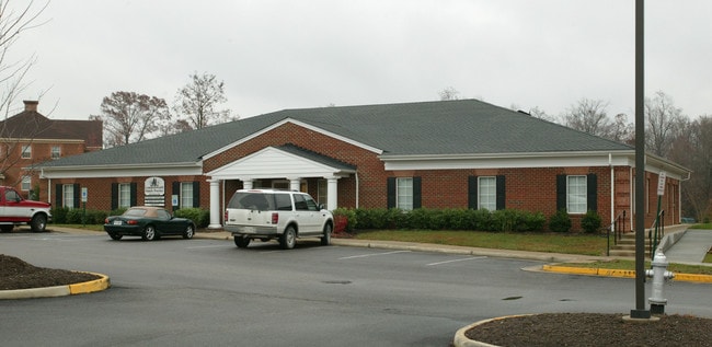
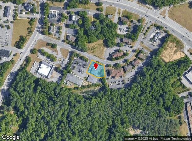
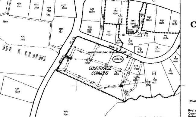
10201 Krause Rd
771-66-15-71-800-000
Courthouse Commons
Medicalbuilding
SOUTHERN LINE OF KRAUSE RD
X
Chesterfield
51041C0307E
Virginia
2025
0.49 AC
2025
Iron Bridge Corridor
100822
Richmond VA
5,978 SF
Richmond, VA
DEMOGRAPHICS near 10201 Krause Rd
1 Mile
3 Mile
5 Mile
2024 Total Population
4,299
29,619
87,313
2029 Population
4,686
32,493
95,801
Pop Growth 2024-2029
+ 9.00%
+ 9.70%
+ 9.72%
Average Age
41
41
40
2024 Total Households
1,643
11,075
32,480
HH Growth 2024-2029
+ 9.19%
+ 9.91%
+ 9.88%
Median Household Inc
$53,453
$83,412
$79,120
Avg Household Size
2.40
2.60
2.60
2024 Avg HH Vehicles
2.00
2.00
2.00
Median Home Value
$233,788
$290,987
$280,035
Median Year Built
1985
1988
1989
Nearby Places
Map Layers
Map Styles
 Street
 Aerial
- Restaurants
- Banks
- Shops
- Fitness
- Groceries
PUBLIC TRANSPORTATION
AIRPORT
Richmond International
DRIVE
WALK
Distance
Richmond International
32 min
19.6 mi
Freight Ports
Virginia Port Authority - Richmond
DRIVE
WALK
Distance
Virginia Port Authority - Richmond
22 min
12.1 mi
SALE & LEASE HISTORY
LISTING DATE
SALE/LEASE

Jan 24, 2019
For Lease
Apr 03, 2017
For Lease
Nearby Properties
Address
Land Use
TOTAL SIZE
Lot Size
Zoning
Address
Land Use
TOTAL SIZE
Lot Size
Zoning
21.01 AC
RMF - RES,
Address
Land Use
TOTAL SIZE
Lot Size
Zoning
121,974 SF
33.25 AC
RMF - RES,
Address
Land Use
TOTAL SIZE
Lot Size
Zoning
5.61 AC
A - AGRICU
Address
Land Use
TOTAL SIZE
Lot Size
Zoning
246,090 SF
7.33 AC
C3 - COMMU
Address
Land Use
TOTAL SIZE
Lot Size
Zoning
278,193 SF
74.49 AC
A - AGRICU
Address
Land Use
TOTAL SIZE
Lot Size
Zoning
95,419 SF
21.13 AC
RMF - RES,
Address
Land Use
TOTAL SIZE
Lot Size
Zoning
100 SF
21.30 AC
R7 - SINGL
Address
Land Use
TOTAL SIZE
Lot Size
Zoning
613,315 SF
12.94 AC
I1 - LT IN
Address
Land Use
TOTAL SIZE
Lot Size
Zoning
16,052 SF
552.02 AC
I1 - LT IN
Address
Land Use
TOTAL SIZE
Lot Size
Zoning
99,934 SF
27.15 AC
A - AGRICU
Address
Land Use
TOTAL SIZE
Lot Size
Zoning
8,432 SF
65.59 AC
A - AGRICU
Address
Land Use
TOTAL SIZE
Lot Size
Zoning
100 SF
10.98 AC
R7 - SINGL
Address
Land Use
TOTAL SIZE
Lot Size
Zoning
65,261 SF
64.31 AC
A - AGRICU
Address
Land Use
TOTAL SIZE
Lot Size
Zoning
119,527 SF
14.89 AC
C5 - GEN B
Address
Land Use
TOTAL SIZE
Lot Size
Zoning
40,729 SF
22.64 AC
A - AGRICU
Address
Land Use
TOTAL SIZE
Lot Size
Zoning
22,151 SF
48.28 AC
A - AGRICU
Address
Land Use
TOTAL SIZE
Lot Size
Zoning
138,787 SF
21.46 AC
A - AGRICU
Address
Land Use
TOTAL SIZE
Lot Size
Zoning
100 SF
10.21 AC
R7 - SINGL
Address
Land Use
TOTAL SIZE
Lot Size
Zoning
193,838 SF
12.66 AC
C3 - COMMU
Address
Land Use
TOTAL SIZE
Lot Size
Zoning
91,100 SF
18.74 AC
A - AGRICU
Address
Land Use
TOTAL SIZE
Lot Size
Zoning
99,471 SF
19.26 AC
A - AGRICU
Address
Land Use
TOTAL SIZE
Lot Size
Zoning
12,210 SF
4.46 AC
RMF - RES,
Address
Land Use
TOTAL SIZE
Lot Size
Zoning
37,266 SF
9.40 AC
R7 - SINGL
Address
Land Use
TOTAL SIZE
Lot Size
Zoning
157,604 SF
0.85 AC
I1 - LT IN
Address
Land Use
TOTAL SIZE
Lot Size
Zoning
73,969 SF
27.42 AC
A - AGRICU
Address
Land Use
TOTAL SIZE
Lot Size
Zoning
20,312 SF
12.76 AC
A - AGRICU
Address
Land Use
TOTAL SIZE
Lot Size
Zoning
78,948 SF
0.63 AC
A - AGRICU
Address
Land Use
TOTAL SIZE
Lot Size
Zoning
92,000 SF
5.41 AC
C5 - GEN B
Address
Land Use
TOTAL SIZE
Lot Size
Zoning
7,072 SF
13.53 AC
A - AGRICU
Address
Land Use
TOTAL SIZE
Lot Size
Zoning
91,010 SF
18.36 AC
I1 - LT IN
The World's #1 Commercial Real Estate Marketplace
Connect with us
© 2025 CoStar Group
The information above has been obtained from sources believed reliable. While we do not doubt its accuracy we have not verified it and make no guarantee, warranty or representation about it. It is your responsibility to independently confirm its accuracy and completeness. Any projections, opinions, assumptions, or estimates used are for example only and do not represent the current or future performance of the property. The value of this transaction to you depends on tax and other factors which should be evaluated by your tax, financial, and legal advisors. You and your advisors should conduct a careful, independent investigation of the property to determine to your satisfaction the suitability of the property for your needs.