Property Record
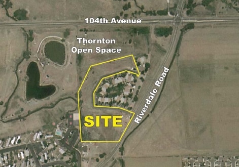
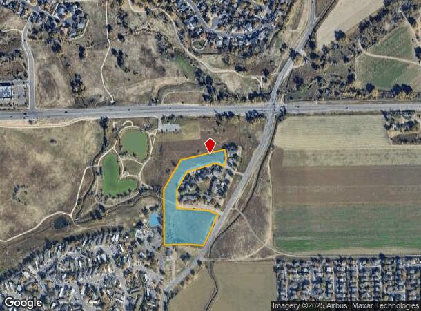
10201 Situs Not Available Rd, Thornton, CO 80229
Property Detail
10201 Situs Not Available Rd
Denver-Aurora-Centennial, CO
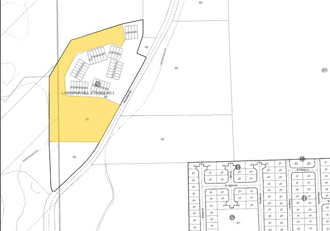
Larkspur Village East
1721-18-1-01-042
SUB:LARKSPUR VILLAGE EAST PUD LOT:1 DESC AS FOLS PT OF THE NE4 OF SEC 18/2/67 DESC AS BEG AT THE NW COR OF SD NE4 TH S 00D 35M 39S E 674/24 FT TO THE TRUE POB TH N 30D 03M 07S E 300 FT TH N 77D 00M 00S E 527/98 FT TH N 88D 48M 06S E 40 FT TO A PT SD
Municipalproperty
Adams
X
Colorado
08001C0318J
1
0
6.50 AC
2025
North Denver
009101
Denver
283,082 SF
NEARBY LISTINGS FOR SALE OR LEASE
DEMOGRAPHICS near 10201 Situs Not Available Rd
1 mile
3 mile
5 mile
2024 Total Population
14,347
100,130
259,022
2029 Population
14,808
103,601
268,141
Pop Growth 2024-2029
+ 3.21%
+ 3.47%
+ 3.52%
Average Age
35
36
36
2024 Total Households
4,726
34,305
89,170
HH Growth 2024-2029
+ 3.32%
+ 3.53%
+ 3.59%
Median Household Inc
$77,872
$83,075
$80,007
Avg Household Size
3.00
2.80
2.80
2024 Avg HH Vehicles
2.00
2.00
2.00
Median Home Value
$350,691
$382,787
$395,103
Median Year Built
1993
1989
1990
Nearby Places
Map Layers
Map Styles
 Street
 Aerial
Transit
 Traffic
 Biking
Places
Listings with unknown addresses are not visible on the map
- Restaurants
- Banks
- Shops
- Fitness
- Groceries
PUBLIC TRANSPORTATION
COMMUTER RAIL
Thornton Crossroads - 104Th Station Track 1 (Union Station to Eastlake & 124th Station - Regional Transportation District)
Drive
Walk
Distance
Thornton Crossroads - 104Th Station Track 1 (Union Station to Eastlake & 124th Station - Regional Transportation District)
3 min
18 min
1.0 mi
Northglenn - 112Th Station Track 1 (Union Station to Eastlake & 124th Station - Regional Transportation District)
Drive
Walk
Distance
Northglenn - 112Th Station Track 1 (Union Station to Eastlake & 124th Station - Regional Transportation District)
6 min
3.1 mi
AIRPORT
Denver International
Drive
Walk
Distance
Denver International
29 min
18.6 mi
Freight Ports
Tulsa Port Of Catoosa
Drive
Walk
Distance
Tulsa Port Of Catoosa
734 min
712.6 mi
Nearby Properties
Address
Land Use
TOTAL SIZE
Lot Size
Zoning
Address
Land Use
TOTAL SIZE
Lot Size
Zoning
295,558 SF
13.41 AC
Address
Land Use
TOTAL SIZE
Lot Size
Zoning
106,680 SF
17.39 AC
Address
Land Use
TOTAL SIZE
Lot Size
Zoning
8,556 SF
382.73 AC
A3
Address
Land Use
TOTAL SIZE
Lot Size
Zoning
549,866 SF
33.82 AC
Address
Land Use
TOTAL SIZE
Lot Size
Zoning
91,326 SF
5.09 AC
Address
Land Use
TOTAL SIZE
Lot Size
Zoning
85,738 SF
4.43 AC
Address
Land Use
TOTAL SIZE
Lot Size
Zoning
282,144 SF
4.01 AC
Address
Land Use
TOTAL SIZE
Lot Size
Zoning
309,126 SF
5.75 AC
Address
Land Use
TOTAL SIZE
Lot Size
Zoning
512,780 SF
25.11 AC
Address
Land Use
TOTAL SIZE
Lot Size
Zoning
141,124 SF
22.35 AC
Address
Land Use
TOTAL SIZE
Lot Size
Zoning
13,224 SF
9.72 AC
Address
Land Use
TOTAL SIZE
Lot Size
Zoning
10,883 SF
4.54 AC
Address
Land Use
TOTAL SIZE
Lot Size
Zoning
616,346 SF
30.04 AC
Address
Land Use
TOTAL SIZE
Lot Size
Zoning
328,674 SF
47.13 AC
Address
Land Use
TOTAL SIZE
Lot Size
Zoning
153,301 SF
26.75 AC
Address
Land Use
TOTAL SIZE
Lot Size
Zoning
547,908 SF
12.24 AC
Address
Land Use
TOTAL SIZE
Lot Size
Zoning
11,200 SF
36.45 AC
A1
Address
Land Use
TOTAL SIZE
Lot Size
Zoning
445,016 SF
23.77 AC
Address
Land Use
TOTAL SIZE
Lot Size
Zoning
250,523 SF
70.73 AC
I1
Address
Land Use
TOTAL SIZE
Lot Size
Zoning
411,708 SF
22.39 AC
Address
Land Use
TOTAL SIZE
Lot Size
Zoning
172,816 SF
59.89 AC
Address
Land Use
TOTAL SIZE
Lot Size
Zoning
459,283 SF
16.88 AC
Address
Land Use
TOTAL SIZE
Lot Size
Zoning
258,279 SF
70.11 AC
I2
Address
Land Use
TOTAL SIZE
Lot Size
Zoning
311,274 SF
18.75 AC
Address
Land Use
TOTAL SIZE
Lot Size
Zoning
319,845 SF
20.66 AC
Address
Land Use
TOTAL SIZE
Lot Size
Zoning
219,959 SF
10 AC
Address
Land Use
TOTAL SIZE
Lot Size
Zoning
208,864 SF
19.26 AC
Address
Land Use
TOTAL SIZE
Lot Size
Zoning
2,240 SF
128.54 AC
A1
Address
Land Use
TOTAL SIZE
Lot Size
Zoning
347,976 SF
11.91 AC
Address
Land Use
TOTAL SIZE
Lot Size
Zoning
355,082 SF
12.29 AC
The World's #1 Commercial Real Estate Marketplace
Connect with us
© 2026 CoStar Group
The information above has been obtained from sources believed reliable. While we do not doubt its accuracy we have not verified it and make no guarantee, warranty or representation about it. It is your responsibility to independently confirm its accuracy and completeness. Any projections, opinions, assumptions, or estimates used are for example only and do not represent the current or future performance of the property. The value of this transaction to you depends on tax and other factors which should be evaluated by your tax, financial, and legal advisors. You and your advisors should conduct a careful, independent investigation of the property to determine to your satisfaction the suitability of the property for your needs.