Property Record
10205 Access Rd, Covington, GA 30014
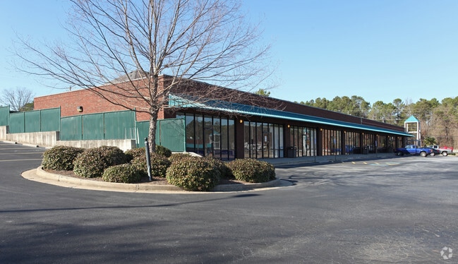


Property Detail
10205 Access Rd
C043000000030A00
1.22AC LT 1A ACCESS RD
Storebuilding
Newton
C1
Georgia
B and X Area of moderate flood hazard, usually the area between the limits of the 100-year and 500-year floods.
1a
2025
1.22 AC
2025
Lithonia/Conyers
100506
Atlanta
11,050 SF
Atlanta-Sandy Springs-Roswell, GA
NEARBY LISTINGS FOR SALE OR LEASE
DEMOGRAPHICS near 10205 Access Rd
1 mile
3 mile
5 mile
2025 Total Population
4,276
28,543
72,199
2030 Population
4,643
31,211
78,646
Pop Growth 2025-2030
+ 8.58%
+ 9.35%
+ 8.93%
Average Age
36
38
38
2025 Total Households
1,598
10,483
25,729
HH Growth 2025-2030
+ 8.57%
+ 9.48%
+ 9.07%
Median Household Inc
$56,666
$68,903
$73,300
Avg Household Size
2.30
2.60
2.70
2025 Avg HH Vehicles
2.00
2.00
2.00
Median Home Value
$184,297
$271,647
$278,122
Median Year Built
1987
1992
1998
Nearby Places
Map Layers
Map Styles
 Street
 Aerial
Transit
 Traffic
 Biking
Places
Listings with unknown addresses are not visible on the map
- Restaurants
- Banks
- Shops
- Fitness
- Groceries
PUBLIC TRANSPORTATION
AIRPORT
Hartsfield - Jackson Atlanta International
Drive
Walk
Distance
Hartsfield - Jackson Atlanta International
50 min
38.0 mi
SALE & LEASE HISTORY
LISTING DATE
SALE/LEASE

Sep 25, 2016
For Lease
Sep 23, 2022
For Lease
Sep 16, 2022
For Sale
Apr 30, 2018
For Lease
Nearby Properties
Address
Land Use
TOTAL SIZE
Lot Size
Zoning
Address
Land Use
TOTAL SIZE
Lot Size
Zoning
8,358 SF
24.01 AC
Address
Land Use
TOTAL SIZE
Lot Size
Zoning
4,734 SF
35.19 AC
RMF
Address
Land Use
TOTAL SIZE
Lot Size
Zoning
207,237 SF
10.61 AC
E1
Address
Land Use
TOTAL SIZE
Lot Size
Zoning
306,886 SF
118.50 AC
R2
Address
Land Use
TOTAL SIZE
Lot Size
Zoning
391,932 SF
73.70 AC
R1
Address
Land Use
TOTAL SIZE
Lot Size
Zoning
14,624 SF
26.09 AC
C1
Address
Land Use
TOTAL SIZE
Lot Size
Zoning
19,292 SF
8.20 AC
H1
Address
Land Use
TOTAL SIZE
Lot Size
Zoning
7,130 SF
36.78 AC
A1
Address
Land Use
TOTAL SIZE
Lot Size
Zoning
45,900 AC
Address
Land Use
TOTAL SIZE
Lot Size
Zoning
88,944 SF
0.98 AC
E1
Address
Land Use
TOTAL SIZE
Lot Size
Zoning
92,162 SF
11.21 AC
R2
Address
Land Use
TOTAL SIZE
Lot Size
Zoning
5,160 SF
45.17 AC
C1
Address
Land Use
TOTAL SIZE
Lot Size
Zoning
262,782 SF
20.94 AC
Address
Land Use
TOTAL SIZE
Lot Size
Zoning
123,360 SF
109.16 AC
I1
Address
Land Use
TOTAL SIZE
Lot Size
Zoning
150,000 SF
34.05 AC
Address
Land Use
TOTAL SIZE
Lot Size
Zoning
34,384 SF
3.32 AC
Address
Land Use
TOTAL SIZE
Lot Size
Zoning
112,884 SF
2.74 AC
Address
Land Use
TOTAL SIZE
Lot Size
Zoning
50,464 SF
12.11 AC
Address
Land Use
TOTAL SIZE
Lot Size
Zoning
222,056 SF
13.35 AC
Address
Land Use
TOTAL SIZE
Lot Size
Zoning
3,888 SF
7.17 AC
C1
Address
Land Use
TOTAL SIZE
Lot Size
Zoning
28,790 SF
3.70 AC
E1
Address
Land Use
TOTAL SIZE
Lot Size
Zoning
33,550 SF
37.40 AC
I1
Address
Land Use
TOTAL SIZE
Lot Size
Zoning
48,144 SF
1.50 AC
E1
Address
Land Use
TOTAL SIZE
Lot Size
Zoning
65,520 SF
35 AC
E6
Address
Land Use
TOTAL SIZE
Lot Size
Zoning
65,008 SF
23.81 AC
R2
Address
Land Use
TOTAL SIZE
Lot Size
Zoning
169,660 SF
35.21 AC
I1
Address
Land Use
TOTAL SIZE
Lot Size
Zoning
4,768 SF
263.26 AC
C1
Address
Land Use
TOTAL SIZE
Lot Size
Zoning
41,772 SF
28.03 AC
E6
Address
Land Use
TOTAL SIZE
Lot Size
Zoning
6,936 SF
8.88 AC
C1
Address
Land Use
TOTAL SIZE
Lot Size
Zoning
28,512 SF
0.52 AC
The World's #1 Commercial Real Estate Marketplace
Connect with us
© 2026 CoStar Group
The information above has been obtained from sources believed reliable. While we do not doubt its accuracy we have not verified it and make no guarantee, warranty or representation about it. It is your responsibility to independently confirm its accuracy and completeness. Any projections, opinions, assumptions, or estimates used are for example only and do not represent the current or future performance of the property. The value of this transaction to you depends on tax and other factors which should be evaluated by your tax, financial, and legal advisors. You and your advisors should conduct a careful, independent investigation of the property to determine to your satisfaction the suitability of the property for your needs.