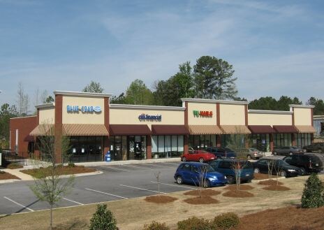
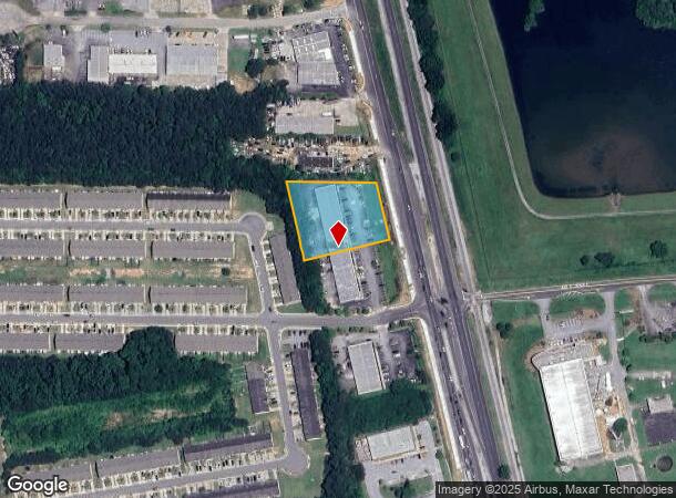
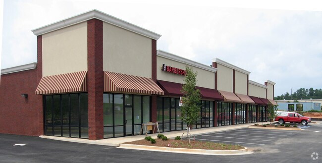
Property Record
10205 Tara Blvd, Jonesboro, GA 30236

NEARBY LISTINGS FOR SALE OR LEASE
Property Detail
10205 Tara Blvd
Atlanta-Sandy Springs-Roswell, GA
Kbd Lovejoy Llc
06-0095A-00A-001
COMMERCIAL
Stripcommercialcenter
Clayton
X
Georgia
13063C0152F
95
2025
1.23 AC
2025
Riverdale/Jonesboro
040623
Atlanta
9,821 SF
DEMOGRAPHICS near 10205 Tara Blvd
1 Mile
3 Mile
5 Mile
2024 Total Population
5,769
45,754
107,887
2029 Population
5,764
45,860
109,020
Pop Growth 2024-2029
(0.09%)
+ 0.23%
+ 1.05%
Average Age
36
37
37
2024 Total Households
1,983
15,066
36,590
HH Growth 2024-2029
(0.05%)
+ 0.18%
+ 1.03%
Median Household Inc
$69,928
$68,443
$67,517
Avg Household Size
2.90
2.90
2.80
2024 Avg HH Vehicles
2.00
2.00
2.00
Median Home Value
$182,790
$200,562
$211,354
Median Year Built
1993
1998
1994
Nearby Places
Map Layers
Map Styles
 Street
 Aerial
- Restaurants
- Banks
- Shops
- Fitness
- Groceries
PUBLIC TRANSPORTATION
AIRPORT
Hartsfield - Jackson Atlanta International
DRIVE
WALK
Distance
Hartsfield - Jackson Atlanta International
25 min
14.9 mi
Freight Ports
Georgia Ports - Savannah
DRIVE
WALK
Distance
Georgia Ports - Savannah
261 min
231.4 mi
SALE & LEASE HISTORY
LISTING DATE
SALE/LEASE

Sep 25, 2016
For Lease
Nov 02, 2017
For Sale
May 10, 2018
For Lease
Nearby Properties
Address
Land Use
TOTAL SIZE
Lot Size
Zoning
Address
Land Use
TOTAL SIZE
Lot Size
Zoning
231,046 SF
97.58 AC
C
Address
Land Use
TOTAL SIZE
Lot Size
Zoning
3,437 SF
121.60 AC
AG
Address
Land Use
TOTAL SIZE
Lot Size
Zoning
7,851 SF
94.84 AC
RS180
Address
Land Use
TOTAL SIZE
Lot Size
Zoning
344,076 SF
69.14 AC
AG
Address
Land Use
TOTAL SIZE
Lot Size
Zoning
250 SF
23.09 AC
C
Address
Land Use
TOTAL SIZE
Lot Size
Zoning
500,415 SF
26.99 AC
HI
Address
Land Use
TOTAL SIZE
Lot Size
Zoning
240 SF
30 AC
RM
Address
Land Use
TOTAL SIZE
Lot Size
Zoning
72,253 SF
50 AC
ER
Address
Land Use
TOTAL SIZE
Lot Size
Zoning
194,270 SF
24.27 AC
C
Address
Land Use
TOTAL SIZE
Lot Size
Zoning
155,204 SF
21.37 AC
I
Address
Land Use
TOTAL SIZE
Lot Size
Zoning
21.01 AC
C
Address
Land Use
TOTAL SIZE
Lot Size
Zoning
18,990 SF
13.11 AC
C
Address
Land Use
TOTAL SIZE
Lot Size
Zoning
5,529 SF
26.29 AC
OI
Address
Land Use
TOTAL SIZE
Lot Size
Zoning
81,986 SF
15 AC
RS180
Address
Land Use
TOTAL SIZE
Lot Size
Zoning
69,505 SF
10.68 AC
GB
Address
Land Use
TOTAL SIZE
Lot Size
Zoning
54,499 SF
10.18 AC
GB
Address
Land Use
TOTAL SIZE
Lot Size
Zoning
55,650 SF
19.71 AC
AG
Address
Land Use
TOTAL SIZE
Lot Size
Zoning
116,822 SF
4.10 AC
RS180
Address
Land Use
TOTAL SIZE
Lot Size
Zoning
289 SF
50.20 AC
C
Address
Land Use
TOTAL SIZE
Lot Size
Zoning
63,256 SF
27.07 AC
I
Address
Land Use
TOTAL SIZE
Lot Size
Zoning
102,653 SF
5.50 AC
ER
Address
Land Use
TOTAL SIZE
Lot Size
Zoning
34,563 SF
4.88 AC
C
Address
Land Use
TOTAL SIZE
Lot Size
Zoning
19.35 AC
ER
Address
Land Use
TOTAL SIZE
Lot Size
Zoning
47,057 SF
6.83 AC
C
Address
Land Use
TOTAL SIZE
Lot Size
Zoning
29,786 SF
15.41 AC
GB
Address
Land Use
TOTAL SIZE
Lot Size
Zoning
1,826 SF
169.71 AC
C
Address
Land Use
TOTAL SIZE
Lot Size
Zoning
3,648 SF
533.15 AC
AG
Address
Land Use
TOTAL SIZE
Lot Size
Zoning
3,512 SF
50 AC
HI
Address
Land Use
TOTAL SIZE
Lot Size
Zoning
12,400 SF
4.24 AC
MXI
Address
Land Use
TOTAL SIZE
Lot Size
Zoning
611 SF
155.70 AC
RMH
The World's #1 Commercial Real Estate Marketplace
Connect with us
© 2025 CoStar Group
The information above has been obtained from sources believed reliable. While we do not doubt its accuracy we have not verified it and make no guarantee, warranty or representation about it. It is your responsibility to independently confirm its accuracy and completeness. Any projections, opinions, assumptions, or estimates used are for example only and do not represent the current or future performance of the property. The value of this transaction to you depends on tax and other factors which should be evaluated by your tax, financial, and legal advisors. You and your advisors should conduct a careful, independent investigation of the property to determine to your satisfaction the suitability of the property for your needs.