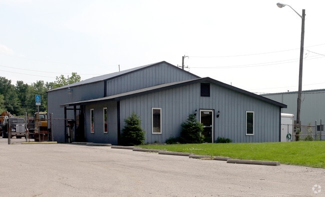
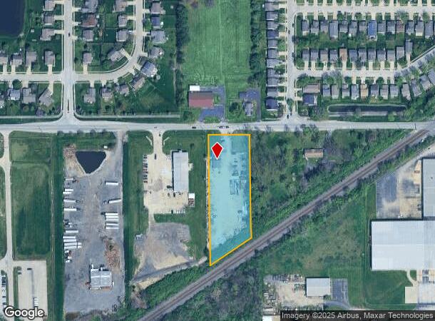
Property Record
10209 E 59Th St, Indianapolis, IN 46236

NEARBY LISTINGS FOR SALE OR LEASE
Property Detail
10209 E 59Th St
49-08-04-124-007.000-407
PT NW1/4 SW1/4 S4 T16 R5 BEG 1106.02FT E OF NW CORE 175FT S 431.24FT SW 214.687FT N 548.051FT TOBEG 1.967AC
Warehouse
Marion
X
Indiana
18097C0180F
1.97 AC
2023
Fort Ben
2024
Indianapolis
330204
Indianapolis-Carmel-Anderson, IN
2,084 SF
DEMOGRAPHICS near 10209 E 59Th St
1 Mile
3 Mile
5 Mile
2024 Total Population
6,848
68,158
163,328
2029 Population
6,724
67,538
162,824
Pop Growth 2024-2029
(1.81%)
(0.91%)
(0.31%)
Average Age
40
36
37
2024 Total Households
2,779
25,568
63,579
HH Growth 2024-2029
(1.48%)
(0.93%)
(0.40%)
Median Household Inc
$60,717
$57,820
$62,436
Avg Household Size
2.40
2.60
2.50
2024 Avg HH Vehicles
2.00
2.00
2.00
Median Home Value
$174,891
$176,854
$200,059
Median Year Built
1994
1987
1981
Nearby Places
Map Layers
Map Styles
 Street
 Aerial
- Restaurants
- Banks
- Shops
- Fitness
- Groceries
PUBLIC TRANSPORTATION
AIRPORT
Indianapolis International
DRIVE
WALK
Distance
Indianapolis International
48 min
27.0 mi
Freight Ports
Port of Toledo
DRIVE
WALK
Distance
Port of Toledo
258 min
212.9 mi
Nearby Properties
Address
Land Use
TOTAL SIZE
Lot Size
Zoning
Address
Land Use
TOTAL SIZE
Lot Size
Zoning
11,154 SF
21.99 AC
Address
Land Use
TOTAL SIZE
Lot Size
Zoning
532,932 SF
61.88 AC
ZO03
Address
Land Use
TOTAL SIZE
Lot Size
Zoning
2,556 SF
35.56 AC
ZO01
Address
Land Use
TOTAL SIZE
Lot Size
Zoning
4,217 SF
7.37 AC
ZO01
Address
Land Use
TOTAL SIZE
Lot Size
Zoning
129,608 SF
54.85 AC
ZO01
Address
Land Use
TOTAL SIZE
Lot Size
Zoning
13,087 SF
57.88 AC
Address
Land Use
TOTAL SIZE
Lot Size
Zoning
136,336 SF
8.74 AC
ZO01
Address
Land Use
TOTAL SIZE
Lot Size
Zoning
1,769 SF
18.27 AC
Address
Land Use
TOTAL SIZE
Lot Size
Zoning
293,952 SF
12.88 AC
ZO01
Address
Land Use
TOTAL SIZE
Lot Size
Zoning
65,095 SF
4.06 AC
ZO01
Address
Land Use
TOTAL SIZE
Lot Size
Zoning
109,200 SF
4.63 AC
ZO01
Address
Land Use
TOTAL SIZE
Lot Size
Zoning
203,720 SF
21.44 AC
Address
Land Use
TOTAL SIZE
Lot Size
Zoning
4,878 SF
25.65 AC
Address
Land Use
TOTAL SIZE
Lot Size
Zoning
206,080 SF
12.97 AC
ZO01
Address
Land Use
TOTAL SIZE
Lot Size
Zoning
3,004 SF
13.79 AC
Address
Land Use
TOTAL SIZE
Lot Size
Zoning
33,588 SF
3.06 AC
ZO01
Address
Land Use
TOTAL SIZE
Lot Size
Zoning
65,541 SF
3.28 AC
ZO01
Address
Land Use
TOTAL SIZE
Lot Size
Zoning
8,386 SF
19.85 AC
Address
Land Use
TOTAL SIZE
Lot Size
Zoning
175,610 SF
23.65 AC
ZO01
Address
Land Use
TOTAL SIZE
Lot Size
Zoning
53,987 SF
2.39 AC
ZO01
Address
Land Use
TOTAL SIZE
Lot Size
Zoning
109,925 SF
9.23 AC
ZO01
Address
Land Use
TOTAL SIZE
Lot Size
Zoning
4,152 SF
19.23 AC
ZO01
Address
Land Use
TOTAL SIZE
Lot Size
Zoning
12,162 SF
18.76 AC
Address
Land Use
TOTAL SIZE
Lot Size
Zoning
105,252 SF
9.96 AC
ZO01
Address
Land Use
TOTAL SIZE
Lot Size
Zoning
151,107 SF
18.64 AC
Address
Land Use
TOTAL SIZE
Lot Size
Zoning
59,900 SF
7.82 AC
ZO01
Address
Land Use
TOTAL SIZE
Lot Size
Zoning
37,082 SF
2.53 AC
ZO01
Address
Land Use
TOTAL SIZE
Lot Size
Zoning
5,430 SF
10.29 AC
ZO01
Address
Land Use
TOTAL SIZE
Lot Size
Zoning
1.98 AC
ZO01
Address
Land Use
TOTAL SIZE
Lot Size
Zoning
80,096 SF
2.72 AC
ZO01
The World's #1 Commercial Real Estate Marketplace
Connect with us
© 2025 CoStar Group
The information above has been obtained from sources believed reliable. While we do not doubt its accuracy we have not verified it and make no guarantee, warranty or representation about it. It is your responsibility to independently confirm its accuracy and completeness. Any projections, opinions, assumptions, or estimates used are for example only and do not represent the current or future performance of the property. The value of this transaction to you depends on tax and other factors which should be evaluated by your tax, financial, and legal advisors. You and your advisors should conduct a careful, independent investigation of the property to determine to your satisfaction the suitability of the property for your needs.