Property Record
10119 Gibsonton Dr, Riverview, FL 33578

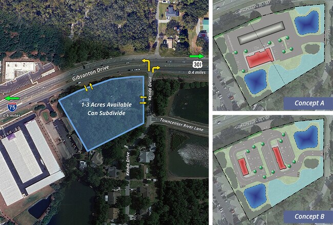
Current Lease Availabilities
NEARBY LISTINGS FOR SALE OR LEASE
Property Detail
10119 Gibsonton Dr
Tampa-St. Petersburg-Clearwater, FL
Unplatted
U-19-30-20-ZZZ-000003-00170.0
Hillsborough
Sfr
Florida
A
1.66 AC
12057C0502J
Southeast Hillsborough
2,036 SF
Tampa/St Petersburg
DEMOGRAPHICS near 10119 Gibsonton Dr
1 Mile
3 Mile
5 Mile
2024 Total Population
7,970
81,258
202,489
2029 Population
8,938
89,349
222,160
Pop Growth 2024-2029
+ 12.15%
+ 9.96%
+ 9.71%
Average Age
39
37
37
2024 Total Households
3,061
29,846
74,025
HH Growth 2024-2029
+ 12.19%
+ 10.15%
+ 9.94%
Median Household Inc
$69,846
$75,251
$76,065
Avg Household Size
2.60
2.70
2.70
2024 Avg HH Vehicles
2.00
2.00
2.00
Median Home Value
$264,503
$268,932
$275,360
Median Year Built
2008
2004
2002
Nearby Places
- Restaurants
- Banks
- Shops
- Fitness
- Groceries
PUBLIC TRANSPORTATION
AIRPORT
Tampa International
DRIVE
WALK
Distance
Tampa International
33 min
23.9 mi
St Pete-Clearwater International
DRIVE
WALK
Distance
St Pete-Clearwater International
50 min
33.1 mi
Freight Ports
Port of Tampa Bay
DRIVE
WALK
Distance
Port of Tampa Bay
20 min
12.0 mi
Nearby Properties
Address
Land Use
TOTAL SIZE
Lot Size
Zoning
Address
Land Use
TOTAL SIZE
Lot Size
Zoning
382,521 SF
24.27 AC
PD
Address
Land Use
TOTAL SIZE
Lot Size
Zoning
363,226 SF
27.91 AC
PD
Address
Land Use
TOTAL SIZE
Lot Size
Zoning
399,150 SF
26.32 AC
PD
Address
Land Use
TOTAL SIZE
Lot Size
Zoning
338,628 SF
14.60 AC
PD
Address
Land Use
TOTAL SIZE
Lot Size
Zoning
339,482 SF
19.15 AC
PD
Address
Land Use
TOTAL SIZE
Lot Size
Zoning
284,156 SF
19.32 AC
PD
Address
Land Use
TOTAL SIZE
Lot Size
Zoning
476,371 SF
41.23 AC
PD
Address
Land Use
TOTAL SIZE
Lot Size
Zoning
248,749 SF
14.83 AC
PD
Address
Land Use
TOTAL SIZE
Lot Size
Zoning
370,924 SF
73.35 AC
PD
Address
Land Use
TOTAL SIZE
Lot Size
Zoning
257,382 SF
52.57 AC
PD
Address
Land Use
TOTAL SIZE
Lot Size
Zoning
284,185 SF
15.31 AC
PD
Address
Land Use
TOTAL SIZE
Lot Size
Zoning
289,109 SF
75.56 AC
AR
Address
Land Use
TOTAL SIZE
Lot Size
Zoning
178,972 SF
16.28 AC
PD
Address
Land Use
TOTAL SIZE
Lot Size
Zoning
92,133 SF
13.05 AC
IPD-1
Address
Land Use
TOTAL SIZE
Lot Size
Zoning
124,865 SF
20.14 AC
PD
Address
Land Use
TOTAL SIZE
Lot Size
Zoning
125,136 SF
13.58 AC
PD
Address
Land Use
TOTAL SIZE
Lot Size
Zoning
184,359 SF
17.06 AC
PD
Address
Land Use
TOTAL SIZE
Lot Size
Zoning
163,701 SF
87.66 AC
PD
Address
Land Use
TOTAL SIZE
Lot Size
Zoning
222,320 SF
18.94 AC
PD
Address
Land Use
TOTAL SIZE
Lot Size
Zoning
139,925 SF
13.92 AC
PD
Address
Land Use
TOTAL SIZE
Lot Size
Zoning
209,218 SF
14.63 AC
PD
Address
Land Use
TOTAL SIZE
Lot Size
Zoning
215,929 SF
26.74 AC
PD
Address
Land Use
TOTAL SIZE
Lot Size
Zoning
95,427 SF
20.06 AC
PD
Address
Land Use
TOTAL SIZE
Lot Size
Zoning
71,836 SF
42.82 AC
ASC-1
Address
Land Use
TOTAL SIZE
Lot Size
Zoning
101,809 SF
15.02 AC
PD
Address
Land Use
TOTAL SIZE
Lot Size
Zoning
149,725 SF
10.10 AC
PD
Address
Land Use
TOTAL SIZE
Lot Size
Zoning
98,325 SF
20.75 AC
PD
Address
Land Use
TOTAL SIZE
Lot Size
Zoning
75,304 SF
4.27 AC
PD
Address
Land Use
TOTAL SIZE
Lot Size
Zoning
175,903 SF
14.97 AC
PD
Address
Land Use
TOTAL SIZE
Lot Size
Zoning
87,925 SF
4.38 AC
PD
The World's #1 Commercial Real Estate Marketplace
Connect with us
© 2025 CoStar Group
The information above has been obtained from sources believed reliable. While we do not doubt its accuracy we have not verified it and make no guarantee, warranty or representation about it. It is your responsibility to independently confirm its accuracy and completeness. Any projections, opinions, assumptions, or estimates used are for example only and do not represent the current or future performance of the property. The value of this transaction to you depends on tax and other factors which should be evaluated by your tax, financial, and legal advisors. You and your advisors should conduct a careful, independent investigation of the property to determine to your satisfaction the suitability of the property for your needs.