Property Record
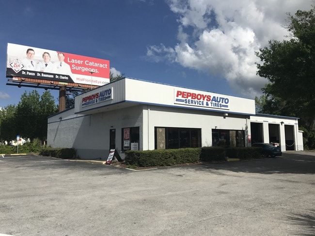
10209 Us Highway 441, Leesburg, FL 34788


NEARBY LISTINGS FOR SALE OR LEASE
Property Detail
10209 Us Highway 441
Orlando-Kissimmee-Sanford, FL
Shademoor Acres
23-19-25-0002-000-02301
FROM NE COR OF LOT 4 OF SHADEMOOR ACRES PB 14 PG 16 RUN S 0-18-30 E ALONG WLY R/W OF RADIO RD A DIST OF 110 FT TO A POINT 10 FT S OF NE COR OF SAID LOT 2 FOR POB RUN S 89-41-30 W PARALLEL WITH & 10 FT S OF N LINE OF SAID LOT 2 A DIST OF 130.22 FT S 0
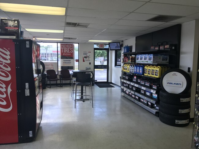
Autorepair
Lake
X
Florida
12069C0333E
4
2024
0.77 AC
2026
Lake County
030302
Orlando
6,460 SF
DEMOGRAPHICS near 10209 Us Highway 441
1 Mile
3 Mile
5 Mile
2024 Total Population
4,788
22,519
52,370
2029 Population
5,580
26,375
61,736
Pop Growth 2024-2029
+ 16.54%
+ 17.12%
+ 17.88%
Average Age
47
47
48
2024 Total Households
2,124
9,873
23,289
HH Growth 2024-2029
+ 16.38%
+ 17.02%
+ 17.92%
Median Household Inc
$53,732
$53,106
$52,925
Avg Household Size
2.30
2.30
2.20
2024 Avg HH Vehicles
2.00
2.00
2.00
Median Home Value
$113,917
$172,949
$182,059
Median Year Built
1990
1987
1987
Nearby Places
Map Layers
Map Styles
 Street
 Aerial
- Restaurants
- Banks
- Shops
- Fitness
- Groceries
SALE & LEASE HISTORY
LISTING DATE
SALE/LEASE

Apr 21, 2017
For Sale
Nearby Properties
Address
Land Use
TOTAL SIZE
Lot Size
Zoning
Address
Land Use
TOTAL SIZE
Lot Size
Zoning
137,651 SF
17.35 AC
RMRP
Address
Land Use
TOTAL SIZE
Lot Size
Zoning
131,655 SF
9.98 AC
RP
Address
Land Use
TOTAL SIZE
Lot Size
Zoning
5,760 SF
110.52 AC
R1
Address
Land Use
TOTAL SIZE
Lot Size
Zoning
546,456 SF
56.22 AC
RP
Address
Land Use
TOTAL SIZE
Lot Size
Zoning
183,700 SF
11.66 AC
R2
Address
Land Use
TOTAL SIZE
Lot Size
Zoning
60,700 SF
784.12 AC
P
Address
Land Use
TOTAL SIZE
Lot Size
Zoning
137,622 SF
18.33 AC
C3
Address
Land Use
TOTAL SIZE
Lot Size
Zoning
39,164 SF
7.25 AC
Address
Land Use
TOTAL SIZE
Lot Size
Zoning
162,928 SF
9.52 AC
R3
Address
Land Use
TOTAL SIZE
Lot Size
Zoning
121,815 SF
33.48 AC
PD
Address
Land Use
TOTAL SIZE
Lot Size
Zoning
2,000 SF
19.74 AC
PFD
Address
Land Use
TOTAL SIZE
Lot Size
Zoning
81,821 SF
12.30 AC
Address
Land Use
TOTAL SIZE
Lot Size
Zoning
40,776 SF
2.28 AC
C1
Address
Land Use
TOTAL SIZE
Lot Size
Zoning
48,478 SF
1.61 AC
CIP
Address
Land Use
TOTAL SIZE
Lot Size
Zoning
77,075 SF
4.66 AC
CP
Address
Land Use
TOTAL SIZE
Lot Size
Zoning
109,792 SF
11.83 AC
RMRP
Address
Land Use
TOTAL SIZE
Lot Size
Zoning
37,310 SF
4.39 AC
Address
Land Use
TOTAL SIZE
Lot Size
Zoning
37,983 SF
5.54 AC
C3
Address
Land Use
TOTAL SIZE
Lot Size
Zoning
124,495 SF
6.49 AC
R3
Address
Land Use
TOTAL SIZE
Lot Size
Zoning
86.22 AC
PD
Address
Land Use
TOTAL SIZE
Lot Size
Zoning
32,704 SF
6.12 AC
R1
Address
Land Use
TOTAL SIZE
Lot Size
Zoning
44,225 SF
15.63 AC
A
Address
Land Use
TOTAL SIZE
Lot Size
Zoning
20,559 SF
5.21 AC
Address
Land Use
TOTAL SIZE
Lot Size
Zoning
33,675 SF
2.74 AC
Address
Land Use
TOTAL SIZE
Lot Size
Zoning
53,312 SF
3.86 AC
RP
Address
Land Use
TOTAL SIZE
Lot Size
Zoning
20,099 SF
1.80 AC
PD
Address
Land Use
TOTAL SIZE
Lot Size
Zoning
32,823 SF
1.93 AC
C3
Address
Land Use
TOTAL SIZE
Lot Size
Zoning
55.05 AC
R1
Address
Land Use
TOTAL SIZE
Lot Size
Zoning
17,948 SF
3.10 AC
C3
Address
Land Use
TOTAL SIZE
Lot Size
Zoning
19,622 SF
4.56 AC
C3
The World's #1 Commercial Real Estate Marketplace
Connect with us
© 2026 CoStar Group
The information above has been obtained from sources believed reliable. While we do not doubt its accuracy we have not verified it and make no guarantee, warranty or representation about it. It is your responsibility to independently confirm its accuracy and completeness. Any projections, opinions, assumptions, or estimates used are for example only and do not represent the current or future performance of the property. The value of this transaction to you depends on tax and other factors which should be evaluated by your tax, financial, and legal advisors. You and your advisors should conduct a careful, independent investigation of the property to determine to your satisfaction the suitability of the property for your needs.