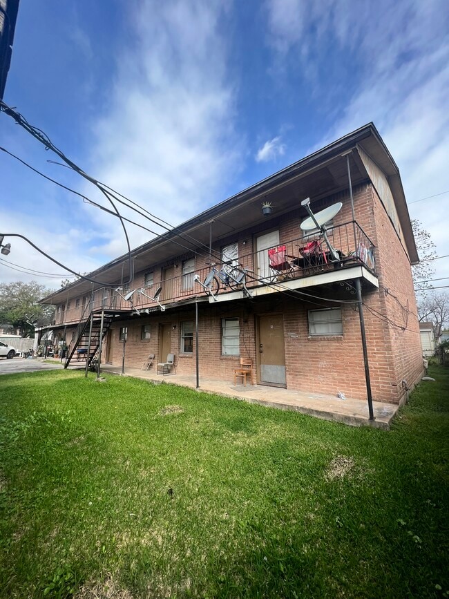
Property Record
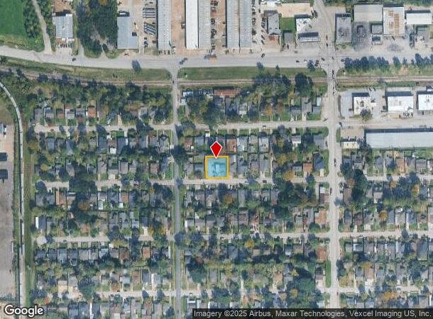
10209 Wiggins St, Houston, TX 77029

NEARBY LISTINGS FOR SALE OR LEASE
Property Detail
10209 Wiggins St
Houston-Pasadena-The Woodlands, TX
Industrial Addition
0552190060016
LTS 16 & 17 BLK 34C INDUSTRIAL
Apartment
Harris
X
Texas
48201C0715M
16,17
2024
0.15 AC
2025
Jacinto City
233502
Houston
6,824 SF
DEMOGRAPHICS near 10209 Wiggins St
1 mile
3 mile
5 mile
2024 Total Population
9,220
55,813
199,488
2029 Population
9,409
57,184
204,971
Pop Growth 2024-2029
+ 2.05%
+ 2.46%
+ 2.75%
Average Age
37
36
36
2024 Total Households
2,970
17,642
65,370
HH Growth 2024-2029
+ 2.02%
+ 2.45%
+ 2.78%
Median Household Inc
$43,154
$42,109
$41,176
Avg Household Size
3.10
3.10
3.00
2024 Avg HH Vehicles
2.00
2.00
2.00
Median Home Value
$109,691
$102,405
$127,638
Median Year Built
1960
1962
1965
Nearby Places
Map Layers
Map Styles
 Street
 Aerial
Transit
 Traffic
 Biking
Places
Listings with unknown addresses are not visible on the map
- Restaurants
- Banks
- Shops
- Fitness
- Groceries
PUBLIC TRANSPORTATION
COMMUTER RAIL
Drive
Walk
Distance
14 min
8.6 mi
AIRPORT
William P Hobby
Drive
Walk
Distance
William P Hobby
24 min
12.5 mi
George Bush Intcntl/Houston
Drive
Walk
Distance
George Bush Intcntl/Houston
31 min
21.7 mi
Freight Ports
Port of Houston
Drive
Walk
Distance
Port of Houston
11 min
4.5 mi
SALE & LEASE HISTORY
LISTING DATE
SALE/LEASE

Mar 30, 2023
For Sale
Nearby Properties
Address
Land Use
TOTAL SIZE
Lot Size
Zoning
Address
Land Use
TOTAL SIZE
Lot Size
Zoning
100.26 AC
Address
Land Use
TOTAL SIZE
Lot Size
Zoning
12,206,592 SF
212.18 AC
Address
Land Use
TOTAL SIZE
Lot Size
Zoning
873,718 SF
49.59 AC
Address
Land Use
TOTAL SIZE
Lot Size
Zoning
1,970,716 SF
118.84 AC
Address
Land Use
TOTAL SIZE
Lot Size
Zoning
1,392,720 SF
83.75 AC
Address
Land Use
TOTAL SIZE
Lot Size
Zoning
592,980 SF
20 AC
Address
Land Use
TOTAL SIZE
Lot Size
Zoning
793,077 SF
49.76 AC
Address
Land Use
TOTAL SIZE
Lot Size
Zoning
2,918,000 SF
69.31 AC
Address
Land Use
TOTAL SIZE
Lot Size
Zoning
663,147 SF
40.63 AC
Address
Land Use
TOTAL SIZE
Lot Size
Zoning
520,866 SF
23.25 AC
Address
Land Use
TOTAL SIZE
Lot Size
Zoning
422,526 SF
27.45 AC
Address
Land Use
TOTAL SIZE
Lot Size
Zoning
351,250 SF
23.84 AC
Address
Land Use
TOTAL SIZE
Lot Size
Zoning
450,084 SF
15.13 AC
Address
Land Use
TOTAL SIZE
Lot Size
Zoning
Address
Land Use
TOTAL SIZE
Lot Size
Zoning
1,149,387 SF
36.61 AC
Address
Land Use
TOTAL SIZE
Lot Size
Zoning
1,113,216 SF
43.99 AC
Address
Land Use
TOTAL SIZE
Lot Size
Zoning
41.94 AC
Address
Land Use
TOTAL SIZE
Lot Size
Zoning
343,265 SF
41.52 AC
Address
Land Use
TOTAL SIZE
Lot Size
Zoning
889,587 SF
137.68 AC
Address
Land Use
TOTAL SIZE
Lot Size
Zoning
331,196 SF
40.14 AC
Address
Land Use
TOTAL SIZE
Lot Size
Zoning
Address
Land Use
TOTAL SIZE
Lot Size
Zoning
240,968 SF
12.45 AC
Address
Land Use
TOTAL SIZE
Lot Size
Zoning
235,624 SF
10.06 AC
Address
Land Use
TOTAL SIZE
Lot Size
Zoning
190,512 SF
8.81 AC
Address
Land Use
TOTAL SIZE
Lot Size
Zoning
141,017 SF
11.90 AC
Address
Land Use
TOTAL SIZE
Lot Size
Zoning
532,658 SF
36.31 AC
Address
Land Use
TOTAL SIZE
Lot Size
Zoning
225,393 SF
20.59 AC
Address
Land Use
TOTAL SIZE
Lot Size
Zoning
264,866 SF
10.46 AC
Address
Land Use
TOTAL SIZE
Lot Size
Zoning
205,768 SF
9.51 AC
Address
Land Use
TOTAL SIZE
Lot Size
Zoning
207,196 SF
16.55 AC
The World's #1 Commercial Real Estate Marketplace
Connect with us
© 2026 CoStar Group
The information above has been obtained from sources believed reliable. While we do not doubt its accuracy we have not verified it and make no guarantee, warranty or representation about it. It is your responsibility to independently confirm its accuracy and completeness. Any projections, opinions, assumptions, or estimates used are for example only and do not represent the current or future performance of the property. The value of this transaction to you depends on tax and other factors which should be evaluated by your tax, financial, and legal advisors. You and your advisors should conduct a careful, independent investigation of the property to determine to your satisfaction the suitability of the property for your needs.