Property Record
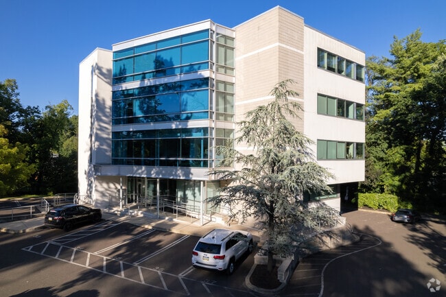
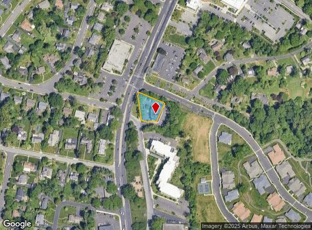
1021 Old York Rd, Abington, PA 19001
Current Lease Availabilities
NEARBY LISTINGS FOR SALE OR LEASE
Property Detail
1021 Old York Rd
30-00-49708-005
INCLUDES 30 00 49712 00 1
Officebuilding
Montgomery
X
Pennsylvania
42091C0401G
10
2024
0.72 AC
2025
Horsham/Willow Grove
201800
Philadelphia
17,908 SF
Philadelphia-Camden-Wilmington, PA-NJ-DE-MD
DEMOGRAPHICS near 1021 Old York Rd
1 Mile
3 Mile
5 Mile
2024 Total Population
12,118
109,506
387,577
2029 Population
12,380
111,716
382,401
Pop Growth 2024-2029
+ 2.16%
+ 2.02%
(1.34%)
Average Age
42
42
42
2024 Total Households
4,700
43,022
151,328
HH Growth 2024-2029
+ 2.38%
+ 2.23%
(1.46%)
Median Household Inc
$110,310
$102,711
$76,314
Avg Household Size
2.40
2.50
2.50
2024 Avg HH Vehicles
2.00
2.00
2.00
Median Home Value
$411,791
$346,518
$283,635
Median Year Built
1954
1956
1956
Nearby Places
- Restaurants
- Banks
- Shops
- Fitness
- Groceries
PUBLIC TRANSPORTATION
TRANSIT/SUBWAY
Noble (R3 - Southeastern Pennsylvania Transportation Authority Regional Rail (SEPTA Regional Rail))
DRIVE
WALK
Distance
Noble (R3 - Southeastern Pennsylvania Transportation Authority Regional Rail (SEPTA Regional Rail))
2 min
11 min
0.6 mi
Rydal (R3 - Southeastern Pennsylvania Transportation Authority Regional Rail (SEPTA Regional Rail))
DRIVE
WALK
Distance
Rydal (R3 - Southeastern Pennsylvania Transportation Authority Regional Rail (SEPTA Regional Rail))
3 min
19 min
1.0 mi
COMMUTER RAIL
Noble (R3 - Southeastern Pennsylvania Transportation Authority Regional Rail (SEPTA Regional Rail))
DRIVE
WALK
Distance
Noble (R3 - Southeastern Pennsylvania Transportation Authority Regional Rail (SEPTA Regional Rail))
2 min
11 min
0.6 mi
Rydal (R3 - Southeastern Pennsylvania Transportation Authority Regional Rail (SEPTA Regional Rail))
DRIVE
WALK
Distance
Rydal (R3 - Southeastern Pennsylvania Transportation Authority Regional Rail (SEPTA Regional Rail))
3 min
20 min
1.0 mi
AIRPORT
Trenton Mercer
DRIVE
WALK
Distance
Trenton Mercer
43 min
24.9 mi
Philadelphia International
DRIVE
WALK
Distance
Philadelphia International
44 min
25.4 mi
Freight Ports
Port of Philadelphia
DRIVE
WALK
Distance
Port of Philadelphia
21 min
11.1 mi
Nearby Properties
Address
Land Use
TOTAL SIZE
Lot Size
Zoning
Address
Land Use
TOTAL SIZE
Lot Size
Zoning
1,556,628 SF
7.70 AC
AO
Address
Land Use
TOTAL SIZE
Lot Size
Zoning
794,476 SF
30.14 AC
PB
Address
Land Use
TOTAL SIZE
Lot Size
Zoning
17,563 SF
1.60 AC
C-O-2.5
Address
Land Use
TOTAL SIZE
Lot Size
Zoning
2,146,150 SF
119.95 AC
M1
Address
Land Use
TOTAL SIZE
Lot Size
Zoning
385,557 SF
5.10 AC
V
Address
Land Use
TOTAL SIZE
Lot Size
Zoning
649,400 SF
55.03 AC
R1
Address
Land Use
TOTAL SIZE
Lot Size
Zoning
487,936 SF
58.50 AC
T
Address
Land Use
TOTAL SIZE
Lot Size
Zoning
406,343 SF
6.59 AC
V
Address
Land Use
TOTAL SIZE
Lot Size
Zoning
636,126 SF
43.18 AC
AP
Address
Land Use
TOTAL SIZE
Lot Size
Zoning
705,687 SF
19.89 AC
C1
Address
Land Use
TOTAL SIZE
Lot Size
Zoning
635,387 SF
10.12 AC
C1
Address
Land Use
TOTAL SIZE
Lot Size
Zoning
498,072 SF
5.39 AC
TC1
Address
Land Use
TOTAL SIZE
Lot Size
Zoning
316,163 SF
45.32 AC
T
Address
Land Use
TOTAL SIZE
Lot Size
Zoning
557,091 SF
21.87 AC
AO
Address
Land Use
TOTAL SIZE
Lot Size
Zoning
222,235 SF
29.23 AC
A
Address
Land Use
TOTAL SIZE
Lot Size
Zoning
582,294 SF
9.07 AC
C1
Address
Land Use
TOTAL SIZE
Lot Size
Zoning
435,888 SF
16.35 AC
MD
Address
Land Use
TOTAL SIZE
Lot Size
Zoning
336,650 SF
61.74 AC
R3
Address
Land Use
TOTAL SIZE
Lot Size
Zoning
167,743 SF
20.70 AC
T
Address
Land Use
TOTAL SIZE
Lot Size
Zoning
232,190 SF
34.16 AC
R4
Address
Land Use
TOTAL SIZE
Lot Size
Zoning
259,505 SF
42.19 AC
V
Address
Land Use
TOTAL SIZE
Lot Size
Zoning
130,115 SF
10.45 AC
PB
Address
Land Use
TOTAL SIZE
Lot Size
Zoning
139,087 SF
2.76 AC
V
Address
Land Use
TOTAL SIZE
Lot Size
Zoning
251,935 SF
13.03 AC
TC1
Address
Land Use
TOTAL SIZE
Lot Size
Zoning
566,988 SF
29.69 AC
C2
Address
Land Use
TOTAL SIZE
Lot Size
Zoning
574,944 SF
5.45 AC
F2
Address
Land Use
TOTAL SIZE
Lot Size
Zoning
336,463 SF
7.52 AC
Address
Land Use
TOTAL SIZE
Lot Size
Zoning
193,334 SF
32.50 AC
NR
Address
Land Use
TOTAL SIZE
Lot Size
Zoning
250,749 SF
47.90 AC
V
Address
Land Use
TOTAL SIZE
Lot Size
Zoning
236,808 SF
17.66 AC
PB
The World's #1 Commercial Real Estate Marketplace
Connect with us
© 2025 CoStar Group
The information above has been obtained from sources believed reliable. While we do not doubt its accuracy we have not verified it and make no guarantee, warranty or representation about it. It is your responsibility to independently confirm its accuracy and completeness. Any projections, opinions, assumptions, or estimates used are for example only and do not represent the current or future performance of the property. The value of this transaction to you depends on tax and other factors which should be evaluated by your tax, financial, and legal advisors. You and your advisors should conduct a careful, independent investigation of the property to determine to your satisfaction the suitability of the property for your needs.