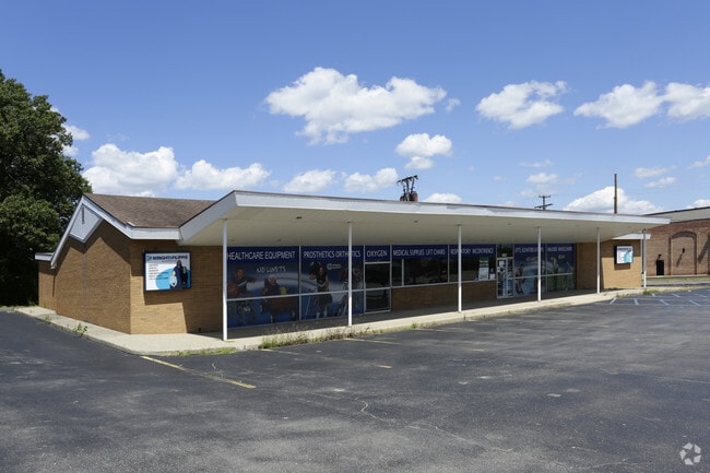
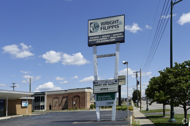
Property Record
1021 28Th St Sw, Wyoming, MI 49509
Current Lease Availabilities
NEARBY LISTINGS FOR SALE OR LEASE
Property Detail
1021 28Th St Sw
Grand Rapids-Wyoming, MI
Sherwood Forest #1
41-17-11-453-034
S 225 FT OF W 1/2 E 1/2 SE 1/4 SW 1/4 SE 1/4 EX COM AT INT OF N LINE OF 28TH ST & W LINE OF JENKINS TH N 88D 43M 44S W 29.0
Commercialnec
Kent
X
Michigan
26081C0412D
81-82
2024
0.74 AC
2025
Southwestern Grand Rapids
013500
West Michigan
7,851 SF
DEMOGRAPHICS near 1021 28Th St Sw
1 Mile
3 Mile
5 Mile
2024 Total Population
14,250
103,374
272,946
2029 Population
14,389
103,731
274,669
Pop Growth 2024-2029
+ 0.98%
+ 0.35%
+ 0.63%
Average Age
36
35
36
2024 Total Households
5,199
37,189
105,964
HH Growth 2024-2029
+ 0.94%
+ 0.43%
+ 0.69%
Median Household Inc
$54,980
$56,712
$62,770
Avg Household Size
2.60
2.70
2.50
2024 Avg HH Vehicles
2.00
2.00
2.00
Median Home Value
$148,004
$156,055
$199,242
Median Year Built
1958
1957
1961
Nearby Places
Map Layers
Map Styles
 Street
 Aerial
- Restaurants
- Banks
- Shops
- Fitness
- Groceries
PUBLIC TRANSPORTATION
COMMUTER RAIL
Grand Rapids Vernon J. Ehlers Station (Pere Marquette - Amtrak)
DRIVE
WALK
Distance
Grand Rapids Vernon J. Ehlers Station (Pere Marquette - Amtrak)
7 min
4.0 mi
AIRPORT
Gerald R Ford International
DRIVE
WALK
Distance
Gerald R Ford International
21 min
11.9 mi
Freight Ports
Port Milwaukee
DRIVE
WALK
Distance
Port Milwaukee
302 min
259.6 mi
Nearby Properties
Address
Land Use
TOTAL SIZE
Lot Size
Zoning
Address
Land Use
TOTAL SIZE
Lot Size
Zoning
899,034 SF
78.93 AC
B1
Address
Land Use
TOTAL SIZE
Lot Size
Zoning
398,607 SF
33.51 AC
R4
Address
Land Use
TOTAL SIZE
Lot Size
Zoning
1,426,319 SF
54.81 AC
SD-IT
Address
Land Use
TOTAL SIZE
Lot Size
Zoning
87.39 AC
I2
Address
Land Use
TOTAL SIZE
Lot Size
Zoning
264,739 SF
26.56 AC
I2
Address
Land Use
TOTAL SIZE
Lot Size
Zoning
22.35 AC
Address
Land Use
TOTAL SIZE
Lot Size
Zoning
536,296 SF
26.16 AC
SD-IT
Address
Land Use
TOTAL SIZE
Lot Size
Zoning
179,436 SF
24.94 AC
I2
Address
Land Use
TOTAL SIZE
Lot Size
Zoning
212,353 SF
16.52 AC
R4
Address
Land Use
TOTAL SIZE
Lot Size
Zoning
20.30 AC
Address
Land Use
TOTAL SIZE
Lot Size
Zoning
348,367 SF
12.15 AC
SD-IT
Address
Land Use
TOTAL SIZE
Lot Size
Zoning
29.13 AC
Address
Land Use
TOTAL SIZE
Lot Size
Zoning
293,441 SF
18 AC
I-1
Address
Land Use
TOTAL SIZE
Lot Size
Zoning
251,562 SF
15.56 AC
MZ
Address
Land Use
TOTAL SIZE
Lot Size
Zoning
162,228 SF
14.31 AC
R4
Address
Land Use
TOTAL SIZE
Lot Size
Zoning
Address
Land Use
TOTAL SIZE
Lot Size
Zoning
349,885 SF
8.92 AC
I1
Address
Land Use
TOTAL SIZE
Lot Size
Zoning
174,256 SF
10.83 AC
SD-IT
Address
Land Use
TOTAL SIZE
Lot Size
Zoning
Address
Land Use
TOTAL SIZE
Lot Size
Zoning
248,360 SF
7.03 AC
SD-IT
Address
Land Use
TOTAL SIZE
Lot Size
Zoning
157,386 SF
13.11 AC
R4
Address
Land Use
TOTAL SIZE
Lot Size
Zoning
442,193 SF
17.90 AC
I1
Address
Land Use
TOTAL SIZE
Lot Size
Zoning
61 AC
R6
Address
Land Use
TOTAL SIZE
Lot Size
Zoning
155,304 SF
17.58 AC
R3-B
Address
Land Use
TOTAL SIZE
Lot Size
Zoning
116,832 SF
14.32 AC
R4
Address
Land Use
TOTAL SIZE
Lot Size
Zoning
246,880 SF
18.33 AC
I-2
Address
Land Use
TOTAL SIZE
Lot Size
Zoning
260,000 SF
10.49 AC
SD-IT
Address
Land Use
TOTAL SIZE
Lot Size
Zoning
124,800 SF
11.19 AC
R4
Address
Land Use
TOTAL SIZE
Lot Size
Zoning
121,842 SF
9.42 AC
R4
Address
Land Use
TOTAL SIZE
Lot Size
Zoning
58,067 SF
4.15 AC
TN-LDR
The World's #1 Commercial Real Estate Marketplace
Connect with us
© 2025 CoStar Group
The information above has been obtained from sources believed reliable. While we do not doubt its accuracy we have not verified it and make no guarantee, warranty or representation about it. It is your responsibility to independently confirm its accuracy and completeness. Any projections, opinions, assumptions, or estimates used are for example only and do not represent the current or future performance of the property. The value of this transaction to you depends on tax and other factors which should be evaluated by your tax, financial, and legal advisors. You and your advisors should conduct a careful, independent investigation of the property to determine to your satisfaction the suitability of the property for your needs.