Property Record
1021 Graham Rd, Stow, OH 44224

NEARBY LISTINGS FOR SALE OR LEASE
-
-
View all Stow listings for sale on LoopNet.com
Property Detail
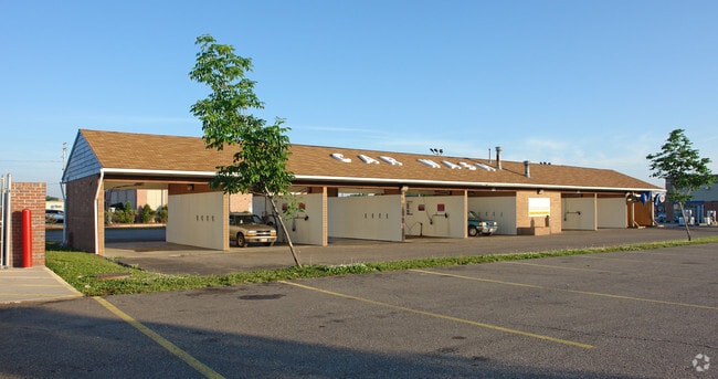
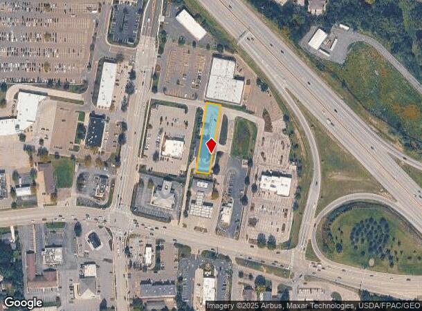
1021 Graham Rd
Akron, OH
Mc Chesney
56-07123
LOT 32 SUB 10 MC CHESNEY N PT GRAHAM RD
Carwash
Summit
X
Ohio
39153C0136F
32
2023
0.39 AC
2025
Akron
530603
Cleveland
4,168 SF
DEMOGRAPHICS near 1021 Graham Rd
1 Mile
3 Mile
5 Mile
2024 Total Population
7,470
72,165
141,865
2029 Population
7,345
71,297
140,371
Pop Growth 2024-2029
(1.67%)
(1.20%)
(1.05%)
Average Age
42
42
41
2024 Total Households
3,325
32,105
61,227
HH Growth 2024-2029
(1.71%)
(1.26%)
(1.09%)
Median Household Inc
$68,743
$68,429
$65,967
Avg Household Size
2.20
2.20
2.20
2024 Avg HH Vehicles
2.00
2.00
2.00
Median Home Value
$169,411
$173,862
$181,258
Median Year Built
1959
1965
1968
Nearby Places
Map Layers
Map Styles
 Street
 Aerial
- Restaurants
- Banks
- Shops
- Fitness
- Groceries
PUBLIC TRANSPORTATION
COMMUTER RAIL
DRIVE
WALK
Distance
14 min
5.7 mi
DRIVE
WALK
Distance
16 min
6.3 mi
AIRPORT
Akron-Canton Regional
DRIVE
WALK
Distance
Akron-Canton Regional
28 min
19.8 mi
Cleveland-Hopkins International
DRIVE
WALK
Distance
Cleveland-Hopkins International
49 min
35.3 mi
Nearby Properties
Address
Land Use
TOTAL SIZE
Lot Size
Zoning
Address
Land Use
TOTAL SIZE
Lot Size
Zoning
188,042 SF
45.24 AC
Address
Land Use
TOTAL SIZE
Lot Size
Zoning
Address
Land Use
TOTAL SIZE
Lot Size
Zoning
246,181 SF
54.04 AC
Address
Land Use
TOTAL SIZE
Lot Size
Zoning
314,622 SF
15.59 AC
Address
Land Use
TOTAL SIZE
Lot Size
Zoning
297,758 SF
23.28 AC
Address
Land Use
TOTAL SIZE
Lot Size
Zoning
115,224 SF
10.30 AC
Address
Land Use
TOTAL SIZE
Lot Size
Zoning
131,124 SF
29.45 AC
Address
Land Use
TOTAL SIZE
Lot Size
Zoning
311,197 SF
10.78 AC
Address
Land Use
TOTAL SIZE
Lot Size
Zoning
396,660 SF
31.89 AC
Address
Land Use
TOTAL SIZE
Lot Size
Zoning
15.41 AC
Address
Land Use
TOTAL SIZE
Lot Size
Zoning
169,260 SF
9.95 AC
Address
Land Use
TOTAL SIZE
Lot Size
Zoning
118,740 SF
15.25 AC
Address
Land Use
TOTAL SIZE
Lot Size
Zoning
145,844 SF
9.80 AC
Address
Land Use
TOTAL SIZE
Lot Size
Zoning
Address
Land Use
TOTAL SIZE
Lot Size
Zoning
Address
Land Use
TOTAL SIZE
Lot Size
Zoning
119,896 SF
3.19 AC
Address
Land Use
TOTAL SIZE
Lot Size
Zoning
Address
Land Use
TOTAL SIZE
Lot Size
Zoning
35,718 SF
69.69 AC
Address
Land Use
TOTAL SIZE
Lot Size
Zoning
90,820 SF
23.72 AC
Address
Land Use
TOTAL SIZE
Lot Size
Zoning
165,600 SF
11.21 AC
Address
Land Use
TOTAL SIZE
Lot Size
Zoning
68,855 SF
32.57 AC
Address
Land Use
TOTAL SIZE
Lot Size
Zoning
136,220 SF
33 AC
Address
Land Use
TOTAL SIZE
Lot Size
Zoning
140,288 SF
19.51 AC
Address
Land Use
TOTAL SIZE
Lot Size
Zoning
31,128 SF
1.48 AC
Address
Land Use
TOTAL SIZE
Lot Size
Zoning
280,603 SF
19.19 AC
Address
Land Use
TOTAL SIZE
Lot Size
Zoning
118,516 SF
22.07 AC
Address
Land Use
TOTAL SIZE
Lot Size
Zoning
21.80 AC
Address
Land Use
TOTAL SIZE
Lot Size
Zoning
12.94 AC
Address
Land Use
TOTAL SIZE
Lot Size
Zoning
Address
Land Use
TOTAL SIZE
Lot Size
Zoning
70,432 SF
2.28 AC
The World's #1 Commercial Real Estate Marketplace
Connect with us
© 2025 CoStar Group
The information above has been obtained from sources believed reliable. While we do not doubt its accuracy we have not verified it and make no guarantee, warranty or representation about it. It is your responsibility to independently confirm its accuracy and completeness. Any projections, opinions, assumptions, or estimates used are for example only and do not represent the current or future performance of the property. The value of this transaction to you depends on tax and other factors which should be evaluated by your tax, financial, and legal advisors. You and your advisors should conduct a careful, independent investigation of the property to determine to your satisfaction the suitability of the property for your needs.