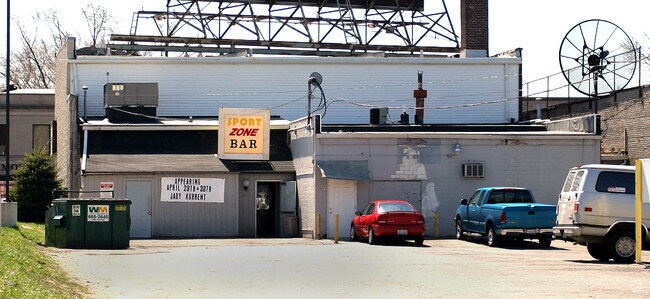
Property Record
1021 Mallett St, Toledo, OH 43612

NEARBY LISTINGS FOR SALE OR LEASE
Property Detail
1021 Mallett St
Toledo, OH
Malletts Addition
10-10271
MALLETTS ADDITION LOT 34 EXC W 10 FT & EXC S10 FT
Commercialacreage
Lucas
X
Ohio
39095C0079F
34
2024
0.13 AC
2024
North Toledo
000302
Toledo
DEMOGRAPHICS near 1021 Mallett St
1 Mile
3 Mile
5 Mile
2024 Total Population
17,785
105,982
230,757
2029 Population
17,472
105,607
229,745
Pop Growth 2024-2029
(1.76%)
(0.35%)
(0.44%)
Average Age
35
38
38
2024 Total Households
7,015
46,056
96,705
HH Growth 2024-2029
(1.85%)
(0.40%)
(0.50%)
Median Household Inc
$43,219
$40,890
$43,892
Avg Household Size
2.40
2.20
2.20
2024 Avg HH Vehicles
2.00
2.00
2.00
Median Home Value
$64,909
$85,798
$100,436
Median Year Built
1946
1950
1954
Nearby Places
Map Layers
Map Styles
 Street
 Aerial
- Restaurants
- Banks
- Shops
- Fitness
- Groceries
PUBLIC TRANSPORTATION
COMMUTER RAIL
Toledo (Capitol Limited - Amtrak, Lake Shore Limited - Amtrak)
DRIVE
WALK
Distance
Toledo (Capitol Limited - Amtrak, Lake Shore Limited - Amtrak)
10 min
5.1 mi
AIRPORT
Eugene F Kranz Toledo Express
DRIVE
WALK
Distance
Eugene F Kranz Toledo Express
38 min
22.6 mi
Freight Ports
Port of Toledo
DRIVE
WALK
Distance
Port of Toledo
19 min
8.3 mi
Nearby Properties
Address
Land Use
TOTAL SIZE
Lot Size
Zoning
Address
Land Use
TOTAL SIZE
Lot Size
Zoning
3,101,694 SF
35.64 AC
10-IC
Address
Land Use
TOTAL SIZE
Lot Size
Zoning
1,046,727 SF
0.41 AC
10-IC
Address
Land Use
TOTAL SIZE
Lot Size
Zoning
169.42 AC
10-IG
Address
Land Use
TOTAL SIZE
Lot Size
Zoning
1,972,579 SF
76.32 AC
10-IG
Address
Land Use
TOTAL SIZE
Lot Size
Zoning
693,900 SF
76.32 AC
10-IG
Address
Land Use
TOTAL SIZE
Lot Size
Zoning
448,269 SF
29.52 AC
10-IC
Address
Land Use
TOTAL SIZE
Lot Size
Zoning
249,216 SF
6.71 AC
10-IC
Address
Land Use
TOTAL SIZE
Lot Size
Zoning
171,946 SF
0.17 AC
10-IC
Address
Land Use
TOTAL SIZE
Lot Size
Zoning
Address
Land Use
TOTAL SIZE
Lot Size
Zoning
328,568 SF
16.37 AC
10-CO
Address
Land Use
TOTAL SIZE
Lot Size
Zoning
296,348 SF
1 AC
10-CO
Address
Land Use
TOTAL SIZE
Lot Size
Zoning
76.32 AC
10-IG
Address
Land Use
TOTAL SIZE
Lot Size
Zoning
169.42 AC
10-IG
Address
Land Use
TOTAL SIZE
Lot Size
Zoning
375,323 SF
10-IC
Address
Land Use
TOTAL SIZE
Lot Size
Zoning
72,306 SF
0.09 AC
10-IC
Address
Land Use
TOTAL SIZE
Lot Size
Zoning
182,983 SF
2 AC
10-CD
Address
Land Use
TOTAL SIZE
Lot Size
Zoning
317,139 SF
25.80 AC
10-IC
Address
Land Use
TOTAL SIZE
Lot Size
Zoning
172,044 SF
12.78 AC
10-MX
Address
Land Use
TOTAL SIZE
Lot Size
Zoning
390,272 SF
5 AC
10-CD
Address
Land Use
TOTAL SIZE
Lot Size
Zoning
228,692 SF
10.45 AC
10-RM36
Address
Land Use
TOTAL SIZE
Lot Size
Zoning
232,758 SF
2 AC
10-CO
Address
Land Use
TOTAL SIZE
Lot Size
Zoning
293,770 SF
13.95 AC
10-RS6
Address
Land Use
TOTAL SIZE
Lot Size
Zoning
297,666 SF
4 AC
10-CO
Address
Land Use
TOTAL SIZE
Lot Size
Zoning
90,113 SF
11.83 AC
10-RS6
Address
Land Use
TOTAL SIZE
Lot Size
Zoning
77,274 SF
4 AC
10-CO
Address
Land Use
TOTAL SIZE
Lot Size
Zoning
208,092 SF
12.49 AC
10-CR
Address
Land Use
TOTAL SIZE
Lot Size
Zoning
158,288 SF
1.22 AC
10-CO
Address
Land Use
TOTAL SIZE
Lot Size
Zoning
158,473 SF
1 AC
10-CD
Address
Land Use
TOTAL SIZE
Lot Size
Zoning
34.13 AC
10-IG
Address
Land Use
TOTAL SIZE
Lot Size
Zoning
91,370 SF
4.60 AC
10-RD6
The World's #1 Commercial Real Estate Marketplace
Connect with us
© 2025 CoStar Group
The information above has been obtained from sources believed reliable. While we do not doubt its accuracy we have not verified it and make no guarantee, warranty or representation about it. It is your responsibility to independently confirm its accuracy and completeness. Any projections, opinions, assumptions, or estimates used are for example only and do not represent the current or future performance of the property. The value of this transaction to you depends on tax and other factors which should be evaluated by your tax, financial, and legal advisors. You and your advisors should conduct a careful, independent investigation of the property to determine to your satisfaction the suitability of the property for your needs.