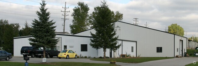
Property Record
1021 N River Rd, West Bend, WI 53090
NEARBY LISTINGS FOR SALE OR LEASE
-
-
View all West Bend listings for sale on LoopNet.com
Property Detail
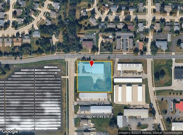
1021 N River Rd
Milwaukee-Waukesha-West Allis, WI
Certified Survey Map No 2809
1120-073-0012
PARCEL 1 CSM 2809 DOC 1357399
Industrialgeneral
Washington
X
Wisconsin
55131C0166D
2.21 AC
2024
North Washington
2024
Milwaukee/Madison
400102
DEMOGRAPHICS near 1021 N River Rd
1 Mile
3 Mile
5 Mile
2024 Total Population
4,973
33,939
43,496
2029 Population
5,073
34,744
44,545
Pop Growth 2024-2029
+ 2.01%
+ 2.37%
+ 2.41%
Average Age
41
42
43
2024 Total Households
1,993
14,543
18,557
HH Growth 2024-2029
+ 2.21%
+ 2.46%
+ 2.49%
Median Household Inc
$80,777
$68,793
$72,246
Avg Household Size
2.40
2.30
2.30
2024 Avg HH Vehicles
2.00
2.00
2.00
Median Home Value
$227,620
$231,072
$249,908
Median Year Built
1979
1975
1977
Nearby Places
Map Layers
Map Styles
 Street
 Aerial
- Restaurants
- Banks
- Shops
- Fitness
- Groceries
PUBLIC TRANSPORTATION
AIRPORT
General Mitchell International
DRIVE
WALK
Distance
General Mitchell International
64 min
45.3 mi
Freight Ports
Port Milwaukee
DRIVE
WALK
Distance
Port Milwaukee
59 min
41.5 mi
Nearby Properties
Address
Land Use
TOTAL SIZE
Lot Size
Zoning
Address
Land Use
TOTAL SIZE
Lot Size
Zoning
195,055 SF
20.57 AC
Address
Land Use
TOTAL SIZE
Lot Size
Zoning
2.98 AC
Address
Land Use
TOTAL SIZE
Lot Size
Zoning
141,575 SF
4.44 AC
Address
Land Use
TOTAL SIZE
Lot Size
Zoning
4,140 SF
29.62 AC
Address
Land Use
TOTAL SIZE
Lot Size
Zoning
9.05 AC
Address
Land Use
TOTAL SIZE
Lot Size
Zoning
36,915 SF
11.79 AC
Address
Land Use
TOTAL SIZE
Lot Size
Zoning
62,974 SF
6.25 AC
Address
Land Use
TOTAL SIZE
Lot Size
Zoning
18.22 AC
Address
Land Use
TOTAL SIZE
Lot Size
Zoning
46.95 AC
Address
Land Use
TOTAL SIZE
Lot Size
Zoning
102,366 SF
9.35 AC
Address
Land Use
TOTAL SIZE
Lot Size
Zoning
50,096 SF
8.91 AC
Address
Land Use
TOTAL SIZE
Lot Size
Zoning
30,046 SF
3.91 AC
Address
Land Use
TOTAL SIZE
Lot Size
Zoning
7.70 AC
Address
Land Use
TOTAL SIZE
Lot Size
Zoning
65,350 SF
5.92 AC
Address
Land Use
TOTAL SIZE
Lot Size
Zoning
27,400 SF
1.83 AC
Address
Land Use
TOTAL SIZE
Lot Size
Zoning
78,372 SF
1.49 AC
Address
Land Use
TOTAL SIZE
Lot Size
Zoning
66,378 SF
10.06 AC
Address
Land Use
TOTAL SIZE
Lot Size
Zoning
11,964 SF
4.74 AC
Address
Land Use
TOTAL SIZE
Lot Size
Zoning
12.71 AC
Address
Land Use
TOTAL SIZE
Lot Size
Zoning
17,649 SF
3.82 AC
Address
Land Use
TOTAL SIZE
Lot Size
Zoning
4.41 AC
Address
Land Use
TOTAL SIZE
Lot Size
Zoning
23,744 SF
4.64 AC
Address
Land Use
TOTAL SIZE
Lot Size
Zoning
17.53 AC
Address
Land Use
TOTAL SIZE
Lot Size
Zoning
28,084 SF
4.31 AC
Address
Land Use
TOTAL SIZE
Lot Size
Zoning
21,624 SF
9.79 AC
Address
Land Use
TOTAL SIZE
Lot Size
Zoning
4,219 SF
5.33 AC
Address
Land Use
TOTAL SIZE
Lot Size
Zoning
27.12 AC
Address
Land Use
TOTAL SIZE
Lot Size
Zoning
22,204 SF
7.18 AC
Address
Land Use
TOTAL SIZE
Lot Size
Zoning
29,760 SF
3.32 AC
Address
Land Use
TOTAL SIZE
Lot Size
Zoning
46,464 SF
2.93 AC
The World's #1 Commercial Real Estate Marketplace
Connect with us
© 2025 CoStar Group
The information above has been obtained from sources believed reliable. While we do not doubt its accuracy we have not verified it and make no guarantee, warranty or representation about it. It is your responsibility to independently confirm its accuracy and completeness. Any projections, opinions, assumptions, or estimates used are for example only and do not represent the current or future performance of the property. The value of this transaction to you depends on tax and other factors which should be evaluated by your tax, financial, and legal advisors. You and your advisors should conduct a careful, independent investigation of the property to determine to your satisfaction the suitability of the property for your needs.