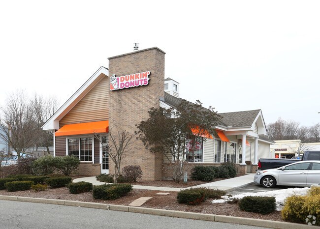
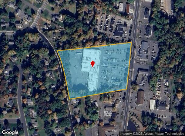
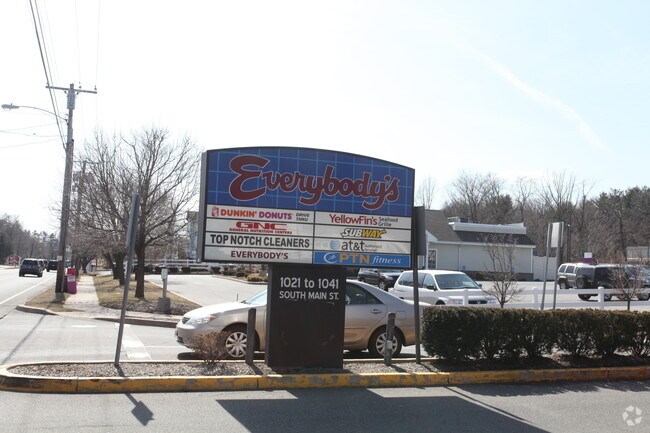
Property Record
1021 S Main St, Cheshire, CT 06410
NEARBY LISTINGS FOR SALE OR LEASE
Property Detail
1021 S Main St
Commercialnec
New Haven
X
Connecticut
09009C0281J
6.71 AC
2025
Cheshire
2025
Westchester/So Connecticut
343400
New Haven-Milford, CT
46,950 SF
CHES-000078-000095
DEMOGRAPHICS near 1021 S Main St
1 Mile
3 Mile
5 Mile
2024 Total Population
5,703
25,646
76,849
2029 Population
5,757
25,713
76,836
Pop Growth 2024-2029
+ 0.95%
+ 0.26%
(0.02%)
Average Age
45
44
42
2024 Total Households
2,082
9,490
27,892
HH Growth 2024-2029
+ 1.01%
+ 0.26%
(0.07%)
Median Household Inc
$120,202
$125,422
$106,141
Avg Household Size
2.60
2.60
2.50
2024 Avg HH Vehicles
2.00
2.00
2.00
Median Home Value
$345,024
$361,672
$326,700
Median Year Built
1971
1972
1970
Nearby Places
Map Layers
Map Styles
 Street
 Aerial
- Restaurants
- Banks
- Shops
- Fitness
- Groceries
PUBLIC TRANSPORTATION
COMMUTER RAIL
DRIVE
WALK
Distance
13 min
5.7 mi
DRIVE
WALK
Distance
14 min
6.1 mi
AIRPORT
Tweed/New Haven
DRIVE
WALK
Distance
Tweed/New Haven
29 min
16.6 mi
Bradley International
DRIVE
WALK
Distance
Bradley International
61 min
42.3 mi
Freight Ports
Port of New Haven
DRIVE
WALK
Distance
Port of New Haven
24 min
14.0 mi
Nearby Properties
Address
Land Use
TOTAL SIZE
Lot Size
Zoning
Address
Land Use
TOTAL SIZE
Lot Size
Zoning
23,338 SF
37.36 AC
R-40
Address
Land Use
TOTAL SIZE
Lot Size
Zoning
72,415 SF
48.10 AC
R-20
Address
Land Use
TOTAL SIZE
Lot Size
Zoning
41.91 AC
RU40
Address
Land Use
TOTAL SIZE
Lot Size
Zoning
168,763 SF
107.36 AC
R-40
Address
Land Use
TOTAL SIZE
Lot Size
Zoning
30.10 AC
ICSDD
Address
Land Use
TOTAL SIZE
Lot Size
Zoning
24.80 AC
R-20A
Address
Land Use
TOTAL SIZE
Lot Size
Zoning
12,250 SF
101.84 AC
R-40
Address
Land Use
TOTAL SIZE
Lot Size
Zoning
116,196 SF
9.45 AC
R-20
Address
Land Use
TOTAL SIZE
Lot Size
Zoning
41,198 SF
2.59 AC
C-1
Address
Land Use
TOTAL SIZE
Lot Size
Zoning
69,492 SF
25 AC
R-40
Address
Land Use
TOTAL SIZE
Lot Size
Zoning
41,031 SF
17.07 AC
R-20
Address
Land Use
TOTAL SIZE
Lot Size
Zoning
12,960 SF
12.25 AC
R-20
Address
Land Use
TOTAL SIZE
Lot Size
Zoning
10,876 SF
5.73 AC
AHD
Address
Land Use
TOTAL SIZE
Lot Size
Zoning
67,494 SF
8.38 AC
C-3
Address
Land Use
TOTAL SIZE
Lot Size
Zoning
62,955 SF
2.76 AC
C-2
Address
Land Use
TOTAL SIZE
Lot Size
Zoning
58,729 SF
12.86 AC
RM11
Address
Land Use
TOTAL SIZE
Lot Size
Zoning
35,463 SF
2.03 AC
R-20
Address
Land Use
TOTAL SIZE
Lot Size
Zoning
48,960 SF
5.94 AC
R-20
Address
Land Use
TOTAL SIZE
Lot Size
Zoning
100.78 AC
R2
Address
Land Use
TOTAL SIZE
Lot Size
Zoning
14,642 SF
1.38 AC
C-2
Address
Land Use
TOTAL SIZE
Lot Size
Zoning
5,145 SF
7.73 AC
C-2
Address
Land Use
TOTAL SIZE
Lot Size
Zoning
30,987 SF
2.16 AC
C-1
Address
Land Use
TOTAL SIZE
Lot Size
Zoning
22,358 SF
3.12 AC
R-20
Address
Land Use
TOTAL SIZE
Lot Size
Zoning
12,840 SF
41.62 AC
R-20
Address
Land Use
TOTAL SIZE
Lot Size
Zoning
4,925 SF
54.59 AC
R-40
Address
Land Use
TOTAL SIZE
Lot Size
Zoning
17,690 SF
2.05 AC
C-2
Address
Land Use
TOTAL SIZE
Lot Size
Zoning
279 AC
RU40
Address
Land Use
TOTAL SIZE
Lot Size
Zoning
19,164 SF
1.20 AC
R-20A
Address
Land Use
TOTAL SIZE
Lot Size
Zoning
17,840 SF
155.33 AC
RU40
The World's #1 Commercial Real Estate Marketplace
Connect with us
© 2025 CoStar Group
The information above has been obtained from sources believed reliable. While we do not doubt its accuracy we have not verified it and make no guarantee, warranty or representation about it. It is your responsibility to independently confirm its accuracy and completeness. Any projections, opinions, assumptions, or estimates used are for example only and do not represent the current or future performance of the property. The value of this transaction to you depends on tax and other factors which should be evaluated by your tax, financial, and legal advisors. You and your advisors should conduct a careful, independent investigation of the property to determine to your satisfaction the suitability of the property for your needs.