Property Record
1021 S Talbot St, Saint Michaels, MD 21663
NEARBY LISTINGS FOR SALE OR LEASE
-
-
View all Saint Michaels listings for sale on LoopNet.com
Property Detail
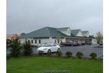
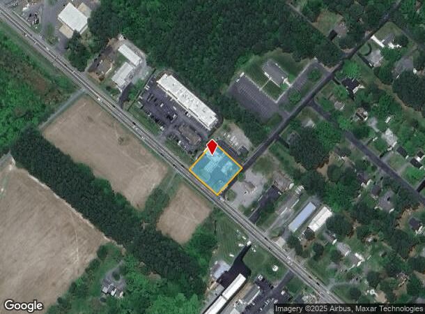
1021 S Talbot St
Easton, MD
Rio Vista Development
02-074273
LOT 7 SC V-155X150 E/S ROUTE 33 RIO VISTA
Conveniencestore
Talbot
X
Maryland
24041C0164D
7 v
2024
0.53 AC
2025
Chesapeake Bay/Salisbury
960700
Other Market Areas
1,872 SF
DEMOGRAPHICS near 1021 S Talbot St
1 Mile
3 Mile
5 Mile
2024 Total Population
1,357
3,517
6,299
2029 Population
1,372
3,567
6,407
Pop Growth 2024-2029
+ 1.11%
+ 1.42%
+ 1.71%
Average Age
51
52
52
2024 Total Households
644
1,678
2,928
HH Growth 2024-2029
+ 0.93%
+ 1.43%
+ 1.67%
Median Household Inc
$74,374
$78,997
$97,461
Avg Household Size
2.10
2.10
2.20
2024 Avg HH Vehicles
2.00
2.00
2.00
Median Home Value
$592,995
$634,650
$661,735
Median Year Built
1974
1977
1978
Nearby Places
Map Layers
Map Styles
 Street
 Aerial
- Restaurants
- Banks
- Shops
- Fitness
- Groceries
Nearby Properties
Address
Land Use
TOTAL SIZE
Lot Size
Zoning
Address
Land Use
TOTAL SIZE
Lot Size
Zoning
78,757 SF
38.03 AC
Address
Land Use
TOTAL SIZE
Lot Size
Zoning
3,640 SF
24.33 AC
Address
Land Use
TOTAL SIZE
Lot Size
Zoning
768 SF
4.80 AC
Address
Land Use
TOTAL SIZE
Lot Size
Zoning
7,686 SF
11.31 AC
Address
Land Use
TOTAL SIZE
Lot Size
Zoning
48,886 SF
4.60 AC
Address
Land Use
TOTAL SIZE
Lot Size
Zoning
16,785 SF
9.08 AC
Address
Land Use
TOTAL SIZE
Lot Size
Zoning
6,750 SF
155.37 AC
Address
Land Use
TOTAL SIZE
Lot Size
Zoning
10,742 SF
2.81 AC
Address
Land Use
TOTAL SIZE
Lot Size
Zoning
10,907 SF
7.10 AC
Address
Land Use
TOTAL SIZE
Lot Size
Zoning
4,464 SF
0.74 AC
Address
Land Use
TOTAL SIZE
Lot Size
Zoning
14,523 SF
0.83 AC
Address
Land Use
TOTAL SIZE
Lot Size
Zoning
19,712 SF
0.70 AC
Address
Land Use
TOTAL SIZE
Lot Size
Zoning
6,000 SF
10.07 AC
Address
Land Use
TOTAL SIZE
Lot Size
Zoning
7,773 SF
0.69 AC
Address
Land Use
TOTAL SIZE
Lot Size
Zoning
10,116 SF
1.16 AC
Address
Land Use
TOTAL SIZE
Lot Size
Zoning
11,431 SF
0.47 AC
Address
Land Use
TOTAL SIZE
Lot Size
Zoning
5,035 SF
0.31 AC
Address
Land Use
TOTAL SIZE
Lot Size
Zoning
720 SF
1.97 AC
Address
Land Use
TOTAL SIZE
Lot Size
Zoning
8,892 SF
3.15 AC
Address
Land Use
TOTAL SIZE
Lot Size
Zoning
18,420 SF
2.22 AC
C2
Address
Land Use
TOTAL SIZE
Lot Size
Zoning
6,058 SF
0.17 AC
Address
Land Use
TOTAL SIZE
Lot Size
Zoning
3,516 SF
2.30 AC
Address
Land Use
TOTAL SIZE
Lot Size
Zoning
3,200 SF
0.73 AC
Address
Land Use
TOTAL SIZE
Lot Size
Zoning
2,400 SF
2.30 AC
Address
Land Use
TOTAL SIZE
Lot Size
Zoning
6,375 SF
0.32 AC
Address
Land Use
TOTAL SIZE
Lot Size
Zoning
3,640 SF
0.26 AC
Address
Land Use
TOTAL SIZE
Lot Size
Zoning
19,029 SF
1.75 AC
Address
Land Use
TOTAL SIZE
Lot Size
Zoning
2,480 SF
1.16 AC
Address
Land Use
TOTAL SIZE
Lot Size
Zoning
3,527 SF
1.79 AC
Address
Land Use
TOTAL SIZE
Lot Size
Zoning
1.44 AC
The World's #1 Commercial Real Estate Marketplace
Connect with us
© 2025 CoStar Group
The information above has been obtained from sources believed reliable. While we do not doubt its accuracy we have not verified it and make no guarantee, warranty or representation about it. It is your responsibility to independently confirm its accuracy and completeness. Any projections, opinions, assumptions, or estimates used are for example only and do not represent the current or future performance of the property. The value of this transaction to you depends on tax and other factors which should be evaluated by your tax, financial, and legal advisors. You and your advisors should conduct a careful, independent investigation of the property to determine to your satisfaction the suitability of the property for your needs.