Property Record
1021 Se 59Th St, Oklahoma City, OK 73129


NEARBY LISTINGS FOR SALE OR LEASE
Property Detail
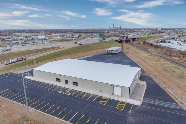
1021 Se 59Th St
132109465
Unpltd Pt Sec 23 11N 3W
Warehouse
UNPLTD PT SW4 SEC 23 11N 3W BEG 475.18FT E & 102.15FT N OF SW/C SW4TH NE542.10FT SE583.25FT W397.71FT TO BEG CONT 2.36ACRS MOREOR LESS
X
Oklahoma
40109C0315H
Oklahoma
2023
2.34 AC
2024
Southeast
107306
Oklahoma City
22,032 SF
Oklahoma City, OK
DEMOGRAPHICS near 1021 Se 59Th St
1 Mile
3 Mile
5 Mile
2024 Total Population
6,234
75,461
233,922
2029 Population
6,409
77,679
241,759
Pop Growth 2024-2029
+ 2.81%
+ 2.94%
+ 3.35%
Average Age
35
35
36
2024 Total Households
2,078
27,663
87,736
HH Growth 2024-2029
+ 2.94%
+ 3.00%
+ 3.47%
Median Household Inc
$39,906
$42,137
$49,945
Avg Household Size
2.90
2.60
2.60
2024 Avg HH Vehicles
2.00
2.00
2.00
Median Home Value
$76,105
$89,422
$124,584
Median Year Built
1963
1970
1973
Nearby Places
Map Layers
Map Styles
 Street
 Aerial
- Restaurants
- Banks
- Shops
- Fitness
- Groceries
PUBLIC TRANSPORTATION
COMMUTER RAIL
DRIVE
WALK
Distance
9 min
5.5 mi
AIRPORT
Will Rogers World
DRIVE
WALK
Distance
Will Rogers World
18 min
7.6 mi
SALE & LEASE HISTORY
LISTING DATE
SALE/LEASE

Dec 22, 2022
For Lease
Aug 30, 2023
For Sale
Nearby Properties
Address
Land Use
TOTAL SIZE
Lot Size
Zoning
Address
Land Use
TOTAL SIZE
Lot Size
Zoning
50.08 AC
Address
Land Use
TOTAL SIZE
Lot Size
Zoning
2,123 SF
53.41 AC
C3
Address
Land Use
TOTAL SIZE
Lot Size
Zoning
57,536 SF
66.21 AC
R4
Address
Land Use
TOTAL SIZE
Lot Size
Zoning
Address
Land Use
TOTAL SIZE
Lot Size
Zoning
64,658 SF
1.86 AC
SPUD
Address
Land Use
TOTAL SIZE
Lot Size
Zoning
347,050 SF
18.56 AC
Address
Land Use
TOTAL SIZE
Lot Size
Zoning
40.90 AC
Address
Land Use
TOTAL SIZE
Lot Size
Zoning
998,813 SF
167.96 AC
I-2
Address
Land Use
TOTAL SIZE
Lot Size
Zoning
70.01 AC
Address
Land Use
TOTAL SIZE
Lot Size
Zoning
232,037 SF
18.80 AC
C-3
Address
Land Use
TOTAL SIZE
Lot Size
Zoning
403,745 SF
26.03 AC
I-3
Address
Land Use
TOTAL SIZE
Lot Size
Zoning
35.11 AC
Address
Land Use
TOTAL SIZE
Lot Size
Zoning
296,429 SF
33.05 AC
I-2
Address
Land Use
TOTAL SIZE
Lot Size
Zoning
303,996 SF
14.90 AC
Address
Land Use
TOTAL SIZE
Lot Size
Zoning
312,675 SF
25.01 AC
Address
Land Use
TOTAL SIZE
Lot Size
Zoning
81,929 SF
8.65 AC
PUD
Address
Land Use
TOTAL SIZE
Lot Size
Zoning
0.34 AC
Address
Land Use
TOTAL SIZE
Lot Size
Zoning
512,046 SF
41.53 AC
I-2
Address
Land Use
TOTAL SIZE
Lot Size
Zoning
152,302 SF
14 AC
SPUD
Address
Land Use
TOTAL SIZE
Lot Size
Zoning
392,100 SF
7.87 AC
I-2
Address
Land Use
TOTAL SIZE
Lot Size
Zoning
18,999 SF
2.92 AC
Address
Land Use
TOTAL SIZE
Lot Size
Zoning
296,700 SF
9.17 AC
I-2
Address
Land Use
TOTAL SIZE
Lot Size
Zoning
501,811 SF
29.33 AC
I-2
Address
Land Use
TOTAL SIZE
Lot Size
Zoning
211,642 SF
15.17 AC
I-2
Address
Land Use
TOTAL SIZE
Lot Size
Zoning
65,009 SF
8.72 AC
SPUD
Address
Land Use
TOTAL SIZE
Lot Size
Zoning
172,136 SF
8.46 AC
R-4
Address
Land Use
TOTAL SIZE
Lot Size
Zoning
37,192 SF
15.97 AC
C-3
Address
Land Use
TOTAL SIZE
Lot Size
Zoning
26,964 SF
7.84 AC
R3
Address
Land Use
TOTAL SIZE
Lot Size
Zoning
204,532 SF
12.46 AC
R-4
The World's #1 Commercial Real Estate Marketplace
Connect with us
© 2026 CoStar Group
The information above has been obtained from sources believed reliable. While we do not doubt its accuracy we have not verified it and make no guarantee, warranty or representation about it. It is your responsibility to independently confirm its accuracy and completeness. Any projections, opinions, assumptions, or estimates used are for example only and do not represent the current or future performance of the property. The value of this transaction to you depends on tax and other factors which should be evaluated by your tax, financial, and legal advisors. You and your advisors should conduct a careful, independent investigation of the property to determine to your satisfaction the suitability of the property for your needs.