Property Record
1021 State Route 17C, Apalachin, NY 13732
NEARBY LISTINGS FOR SALE OR LEASE
-
-
View all Apalachin listings for sale on LoopNet.com
Property Detail
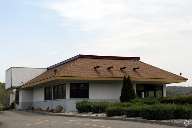
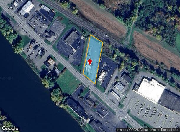
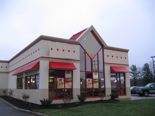
1021 State Route 17C
Restaurantdrivein
Tioga
AE
New York
36107C0401E
21.000
2025
1.50 AC
2024
Other Market Areas
020402
Binghamton, NY
2,712 SF
493089-129-011-0001-021-000-0000
DEMOGRAPHICS near 1021 State Route 17C
1 Mile
3 Mile
5 Mile
2024 Total Population
972
6,534
12,092
2029 Population
953
6,397
11,832
Pop Growth 2024-2029
(1.95%)
(2.10%)
(2.15%)
Average Age
44
43
43
2024 Total Households
437
2,874
5,143
HH Growth 2024-2029
(2.06%)
(2.09%)
(2.18%)
Median Household Inc
$62,692
$61,882
$66,835
Avg Household Size
2.20
2.20
2.30
2024 Avg HH Vehicles
2.00
2.00
2.00
Median Home Value
$134,177
$132,250
$138,596
Median Year Built
1953
1953
1960
Nearby Places
Map Layers
Map Styles
 Street
 Aerial
- Restaurants
- Banks
- Shops
- Fitness
- Groceries
PUBLIC TRANSPORTATION
AIRPORT
Ithaca Tompkins International
DRIVE
WALK
Distance
Ithaca Tompkins International
60 min
36.2 mi
Freight Ports
Albany, NY Port
DRIVE
WALK
Distance
Albany, NY Port
191 min
158.9 mi
Nearby Properties
Address
Land Use
TOTAL SIZE
Lot Size
Zoning
Address
Land Use
TOTAL SIZE
Lot Size
Zoning
201,600 SF
162.49 AC
ZONE
Address
Land Use
TOTAL SIZE
Lot Size
Zoning
176,000 SF
29.81 AC
ZONE
Address
Land Use
TOTAL SIZE
Lot Size
Zoning
3,200 SF
4.40 AC
ZONE
Address
Land Use
TOTAL SIZE
Lot Size
Zoning
128,240 SF
36.55 AC
ZONE
Address
Land Use
TOTAL SIZE
Lot Size
Zoning
69,525 SF
39 AC
ZONE
Address
Land Use
TOTAL SIZE
Lot Size
Zoning
10.10 AC
ZONE
Address
Land Use
TOTAL SIZE
Lot Size
Zoning
12,000 SF
32.16 AC
ZONE
Address
Land Use
TOTAL SIZE
Lot Size
Zoning
56,564 SF
9.67 AC
ZONE
Address
Land Use
TOTAL SIZE
Lot Size
Zoning
58,430 SF
6.27 AC
ZONE
Address
Land Use
TOTAL SIZE
Lot Size
Zoning
3,300 SF
4 AC
ZONE
Address
Land Use
TOTAL SIZE
Lot Size
Zoning
56,028 SF
2.08 AC
ZONE
Address
Land Use
TOTAL SIZE
Lot Size
Zoning
73,888 SF
34.61 AC
ZONE
Address
Land Use
TOTAL SIZE
Lot Size
Zoning
65,786 SF
11.50 AC
ZONE
Address
Land Use
TOTAL SIZE
Lot Size
Zoning
25,088 SF
3.82 AC
ZONE
Address
Land Use
TOTAL SIZE
Lot Size
Zoning
103.10 AC
Address
Land Use
TOTAL SIZE
Lot Size
Zoning
2.40 AC
Address
Land Use
TOTAL SIZE
Lot Size
Zoning
8,670 SF
0.51 AC
ZONE
Address
Land Use
TOTAL SIZE
Lot Size
Zoning
2,502 SF
50.12 AC
ZONE
Address
Land Use
TOTAL SIZE
Lot Size
Zoning
18,522 SF
0.93 AC
ZONE
Address
Land Use
TOTAL SIZE
Lot Size
Zoning
40,443 SF
0.93 AC
ZONE
Address
Land Use
TOTAL SIZE
Lot Size
Zoning
22.50 AC
Address
Land Use
TOTAL SIZE
Lot Size
Zoning
7,326 SF
0.38 AC
ZONE
Address
Land Use
TOTAL SIZE
Lot Size
Zoning
83,860 SF
8.48 AC
ZONE
Address
Land Use
TOTAL SIZE
Lot Size
Zoning
15,888 SF
3 AC
ZONE
Address
Land Use
TOTAL SIZE
Lot Size
Zoning
81,402 SF
4.84 AC
ZONE
Address
Land Use
TOTAL SIZE
Lot Size
Zoning
21,218 SF
1.10 AC
ZONE
Address
Land Use
TOTAL SIZE
Lot Size
Zoning
7.92 AC
ZONE
Address
Land Use
TOTAL SIZE
Lot Size
Zoning
31.54 AC
ZONE
Address
Land Use
TOTAL SIZE
Lot Size
Zoning
56,800 SF
4.83 AC
ZONE
Address
Land Use
TOTAL SIZE
Lot Size
Zoning
8,800 SF
0.46 AC
ZONE
The World's #1 Commercial Real Estate Marketplace
Connect with us
© 2026 CoStar Group
The information above has been obtained from sources believed reliable. While we do not doubt its accuracy we have not verified it and make no guarantee, warranty or representation about it. It is your responsibility to independently confirm its accuracy and completeness. Any projections, opinions, assumptions, or estimates used are for example only and do not represent the current or future performance of the property. The value of this transaction to you depends on tax and other factors which should be evaluated by your tax, financial, and legal advisors. You and your advisors should conduct a careful, independent investigation of the property to determine to your satisfaction the suitability of the property for your needs.