Property Record
1021 Sugar Mill Rd, Longmont, CO 80501
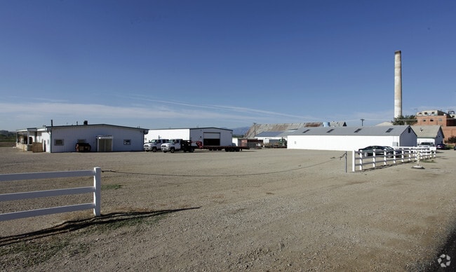


Property Detail
1021 Sugar Mill Rd
Boulder, CO
PART OF PARCEL 2 AS PER DOCKET SE-87-14 07-07/87 AS LOCATED IN SEC 1 & 2 & 12-2N-69 AS PER DEEDS 876124-25 09/10/87 TOTAL 4.3 ACS M/L SEE SPLIT 105047
1315120-00-033
BOULDER
Warehouse
Colorado
B and X Area of moderate flood hazard, usually the area between the limits of the 100-year and 500-year floods.
4
2024
4.43 AC
2025
Boulder County
013302
Denver
22,155 SF
NEARBY LISTINGS FOR SALE OR LEASE
DEMOGRAPHICS near 1021 Sugar Mill Rd
1 mile
3 mile
5 mile
2024 Total Population
6,224
59,971
103,773
2029 Population
6,310
60,176
104,286
Pop Growth 2024-2029
+ 1.38%
+ 0.34%
+ 0.49%
Average Age
41
41
41
2024 Total Households
2,455
23,633
41,460
HH Growth 2024-2029
+ 1.71%
+ 0.41%
+ 0.46%
Median Household Inc
$97,817
$83,793
$87,619
Avg Household Size
2.40
2.50
2.40
2024 Avg HH Vehicles
2.00
2.00
2.00
Median Home Value
$492,567
$580,928
$635,390
Median Year Built
1998
1986
1990
Nearby Places
Map Layers
Map Styles
 Street
 Aerial
Transit
 Traffic
 Biking
Places
Listings with unknown addresses are not visible on the map
- Restaurants
- Banks
- Shops
- Fitness
- Groceries
PUBLIC TRANSPORTATION
AIRPORT
Denver International
Drive
Walk
Distance
Denver International
48 min
42.2 mi
Freight Ports
Tulsa Port Of Catoosa
Drive
Walk
Distance
Tulsa Port Of Catoosa
754 min
736.3 mi
Nearby Properties
Address
Land Use
TOTAL SIZE
Lot Size
Zoning
Address
Land Use
TOTAL SIZE
Lot Size
Zoning
638,659 SF
62.59 AC
Address
Land Use
TOTAL SIZE
Lot Size
Zoning
1,152 SF
17.20 AC
Address
Land Use
TOTAL SIZE
Lot Size
Zoning
38.30 AC
Address
Land Use
TOTAL SIZE
Lot Size
Zoning
219,393 SF
25.13 AC
Address
Land Use
TOTAL SIZE
Lot Size
Zoning
73.36 AC
A
Address
Land Use
TOTAL SIZE
Lot Size
Zoning
1,092 SF
150.73 AC
A
Address
Land Use
TOTAL SIZE
Lot Size
Zoning
146.34 AC
A
Address
Land Use
TOTAL SIZE
Lot Size
Zoning
34,137 SF
19.99 AC
Address
Land Use
TOTAL SIZE
Lot Size
Zoning
75.02 AC
A
Address
Land Use
TOTAL SIZE
Lot Size
Zoning
139.01 AC
A
Address
Land Use
TOTAL SIZE
Lot Size
Zoning
54.45 AC
Address
Land Use
TOTAL SIZE
Lot Size
Zoning
45.32 AC
Address
Land Use
TOTAL SIZE
Lot Size
Zoning
333,909 SF
143.20 AC
Address
Land Use
TOTAL SIZE
Lot Size
Zoning
277,321 SF
14.96 AC
Address
Land Use
TOTAL SIZE
Lot Size
Zoning
33.81 AC
Address
Land Use
TOTAL SIZE
Lot Size
Zoning
152,160 SF
9.02 AC
Address
Land Use
TOTAL SIZE
Lot Size
Zoning
83.57 AC
A
Address
Land Use
TOTAL SIZE
Lot Size
Zoning
107,805 SF
7.45 AC
Address
Land Use
TOTAL SIZE
Lot Size
Zoning
146,153 SF
13.60 AC
Address
Land Use
TOTAL SIZE
Lot Size
Zoning
1,000 SF
71.43 AC
A
Address
Land Use
TOTAL SIZE
Lot Size
Zoning
152,160 SF
10.48 AC
Address
Land Use
TOTAL SIZE
Lot Size
Zoning
71.22 AC
A
Address
Land Use
TOTAL SIZE
Lot Size
Zoning
133,569 SF
14.67 AC
Address
Land Use
TOTAL SIZE
Lot Size
Zoning
13.93 AC
Address
Land Use
TOTAL SIZE
Lot Size
Zoning
199,578 SF
12.94 AC
Address
Land Use
TOTAL SIZE
Lot Size
Zoning
358,412 SF
13.52 AC
Address
Land Use
TOTAL SIZE
Lot Size
Zoning
126,601 SF
13.39 AC
Address
Land Use
TOTAL SIZE
Lot Size
Zoning
215,229 SF
25.58 AC
Address
Land Use
TOTAL SIZE
Lot Size
Zoning
344,797 SF
11.81 AC
Address
Land Use
TOTAL SIZE
Lot Size
Zoning
90,000 SF
8.38 AC
The World's #1 Commercial Real Estate Marketplace
Connect with us
© 2026 CoStar Group
The information above has been obtained from sources believed reliable. While we do not doubt its accuracy we have not verified it and make no guarantee, warranty or representation about it. It is your responsibility to independently confirm its accuracy and completeness. Any projections, opinions, assumptions, or estimates used are for example only and do not represent the current or future performance of the property. The value of this transaction to you depends on tax and other factors which should be evaluated by your tax, financial, and legal advisors. You and your advisors should conduct a careful, independent investigation of the property to determine to your satisfaction the suitability of the property for your needs.