Property Record
10210 Fulton St, Houston, TX 77076
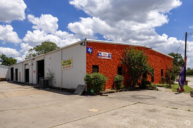
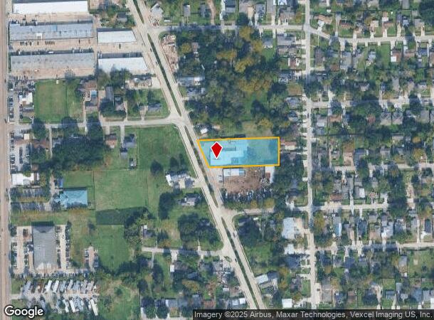
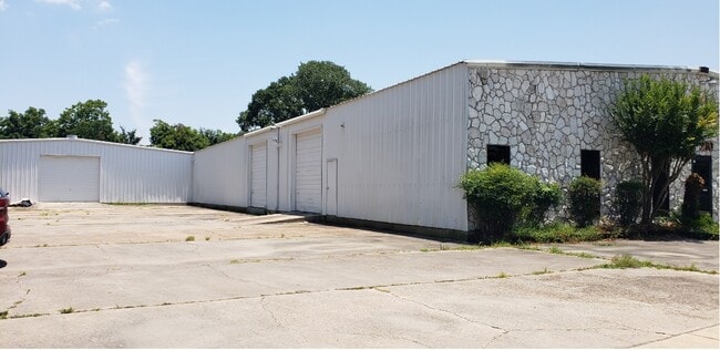

This Property Is For Sale
NEARBY LISTINGS FOR SALE OR LEASE
Property Detail
10210 Fulton St
0352540240039
Thatchers Gardens
Warehouse
TRS 48L-1 48M 48N 48P 48R 48S & 48T (1,397 SQ FT EASEMENT) THATCHERS GARDENS
X
Harris
48201C0660M
Texas
2024
1.10 AC
2025
North Outer Loop
221301
Houston
13,500 SF
Houston-The Woodlands-Sugar Land, TX
DEMOGRAPHICS near 10210 Fulton St
1 Mile
3 Mile
5 Mile
2024 Total Population
20,274
126,712
339,566
2029 Population
20,542
129,502
348,378
Pop Growth 2024-2029
+ 1.32%
+ 2.20%
+ 2.60%
Average Age
36
36
36
2024 Total Households
6,250
40,586
117,847
HH Growth 2024-2029
+ 1.26%
+ 2.32%
+ 2.78%
Median Household Inc
$35,770
$38,881
$48,847
Avg Household Size
3.10
3.00
2.80
2024 Avg HH Vehicles
2.00
2.00
2.00
Median Home Value
$159,447
$171,653
$226,125
Median Year Built
1959
1966
1969
Nearby Places
Map Layers
Map Styles
 Street
 Aerial
- Restaurants
- Banks
- Shops
- Fitness
- Groceries
PUBLIC TRANSPORTATION
COMMUTER RAIL
DRIVE
WALK
Distance
13 min
6.7 mi
AIRPORT
George Bush Intcntl/Houston
DRIVE
WALK
Distance
George Bush Intcntl/Houston
20 min
13.5 mi
William P Hobby
DRIVE
WALK
Distance
William P Hobby
33 min
19.5 mi
Freight Ports
Port of Houston
DRIVE
WALK
Distance
Port of Houston
25 min
15.1 mi
Nearby Properties
Address
Land Use
TOTAL SIZE
Lot Size
Zoning
Address
Land Use
TOTAL SIZE
Lot Size
Zoning
474,326 SF
43.16 AC
Address
Land Use
TOTAL SIZE
Lot Size
Zoning
432,691 SF
3.26 AC
Address
Land Use
TOTAL SIZE
Lot Size
Zoning
594,105 SF
43.68 AC
Address
Land Use
TOTAL SIZE
Lot Size
Zoning
279,452 SF
5.69 AC
Address
Land Use
TOTAL SIZE
Lot Size
Zoning
276,332 SF
6.05 AC
Address
Land Use
TOTAL SIZE
Lot Size
Zoning
545,628 SF
19.41 AC
Address
Land Use
TOTAL SIZE
Lot Size
Zoning
531,786 SF
17.60 AC
Address
Land Use
TOTAL SIZE
Lot Size
Zoning
194,990 SF
16.36 AC
Address
Land Use
TOTAL SIZE
Lot Size
Zoning
213,548 SF
16.98 AC
Address
Land Use
TOTAL SIZE
Lot Size
Zoning
105,268 SF
7.26 AC
Address
Land Use
TOTAL SIZE
Lot Size
Zoning
200,511 SF
9.48 AC
Address
Land Use
TOTAL SIZE
Lot Size
Zoning
188,582 SF
17.94 AC
Address
Land Use
TOTAL SIZE
Lot Size
Zoning
43.68 AC
Address
Land Use
TOTAL SIZE
Lot Size
Zoning
179,804 SF
11.24 AC
Address
Land Use
TOTAL SIZE
Lot Size
Zoning
169,075 SF
11.70 AC
Address
Land Use
TOTAL SIZE
Lot Size
Zoning
85,376 SF
4.35 AC
Address
Land Use
TOTAL SIZE
Lot Size
Zoning
66,588 SF
3.95 AC
Address
Land Use
TOTAL SIZE
Lot Size
Zoning
29,029 SF
17.85 AC
Address
Land Use
TOTAL SIZE
Lot Size
Zoning
257,748 SF
10.70 AC
Address
Land Use
TOTAL SIZE
Lot Size
Zoning
69,257 SF
20.32 AC
Address
Land Use
TOTAL SIZE
Lot Size
Zoning
207,101 SF
6.99 AC
Address
Land Use
TOTAL SIZE
Lot Size
Zoning
190,085 SF
10.96 AC
Address
Land Use
TOTAL SIZE
Lot Size
Zoning
184,536 SF
10 AC
Address
Land Use
TOTAL SIZE
Lot Size
Zoning
108,155 SF
14.64 AC
Address
Land Use
TOTAL SIZE
Lot Size
Zoning
126,662 SF
4.77 AC
Address
Land Use
TOTAL SIZE
Lot Size
Zoning
112,212 SF
10.51 AC
Address
Land Use
TOTAL SIZE
Lot Size
Zoning
192,139 SF
8.27 AC
Address
Land Use
TOTAL SIZE
Lot Size
Zoning
84,582 SF
4.86 AC
Address
Land Use
TOTAL SIZE
Lot Size
Zoning
131,494 SF
Address
Land Use
TOTAL SIZE
Lot Size
Zoning
69,777 SF
2.36 AC
The World's #1 Commercial Real Estate Marketplace
Connect with us
© 2025 CoStar Group
The information above has been obtained from sources believed reliable. While we do not doubt its accuracy we have not verified it and make no guarantee, warranty or representation about it. It is your responsibility to independently confirm its accuracy and completeness. Any projections, opinions, assumptions, or estimates used are for example only and do not represent the current or future performance of the property. The value of this transaction to you depends on tax and other factors which should be evaluated by your tax, financial, and legal advisors. You and your advisors should conduct a careful, independent investigation of the property to determine to your satisfaction the suitability of the property for your needs.