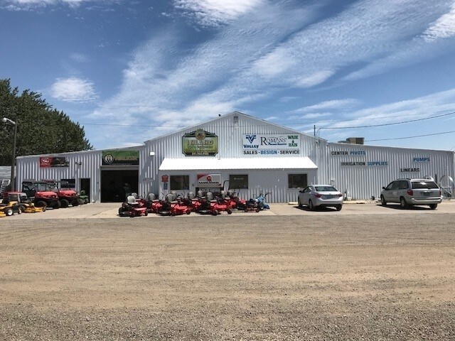
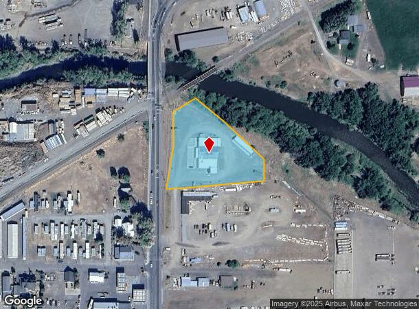
Property Record
10213 N Mcalister Rd, La Grande, OR 97850
NEARBY LISTINGS FOR SALE OR LEASE
Property Detail
10213 N Mcalister Rd
La Grande, OR
Union County Co Op Subdivision
02S3834DC-2000-A-1-102
Union
Taxexempt
Oregon
0
2.25 AC
2025
Oregon East Area
970800
Other Market Areas
11,228 SF
DEMOGRAPHICS near 10213 N Mcalister Rd
1 Mile
3 Mile
5 Mile
2024 Total Population
1,295
13,181
17,249
2029 Population
1,307
13,248
17,321
Pop Growth 2024-2029
+ 0.93%
+ 0.51%
+ 0.42%
Average Age
43
39
40
2024 Total Households
528
5,532
7,150
HH Growth 2024-2029
+ 0.76%
+ 0.51%
+ 0.42%
Median Household Inc
$62,059
$48,306
$54,013
Avg Household Size
2.40
2.30
2.30
2024 Avg HH Vehicles
2.00
2.00
2.00
Median Home Value
$278,494
$233,470
$256,184
Median Year Built
1982
1974
1972
Nearby Places
Map Layers
Map Styles
 Street
 Aerial
- Restaurants
- Banks
- Shops
- Fitness
- Groceries
Nearby Properties
Address
Land Use
TOTAL SIZE
Lot Size
Zoning
Address
Land Use
TOTAL SIZE
Lot Size
Zoning
213,886 SF
22.04 AC
LG-PF
Address
Land Use
TOTAL SIZE
Lot Size
Zoning
166,041 SF
30.11 AC
LG-PF
Address
Land Use
TOTAL SIZE
Lot Size
Zoning
84,605 SF
4.79 AC
LG-R3
Address
Land Use
TOTAL SIZE
Lot Size
Zoning
103,468 SF
22.30 AC
LG-PF
Address
Land Use
TOTAL SIZE
Lot Size
Zoning
44,861 SF
30.99 AC
LG-PF
Address
Land Use
TOTAL SIZE
Lot Size
Zoning
50,357 SF
4.24 AC
LG-PF
Address
Land Use
TOTAL SIZE
Lot Size
Zoning
182,591 SF
6.72 AC
IC-C1
Address
Land Use
TOTAL SIZE
Lot Size
Zoning
27,803 SF
2.38 AC
LG-PF
Address
Land Use
TOTAL SIZE
Lot Size
Zoning
42,352 SF
LG-PF
Address
Land Use
TOTAL SIZE
Lot Size
Zoning
12,456 SF
1.36 AC
LG-GC
Address
Land Use
TOTAL SIZE
Lot Size
Zoning
37,127 SF
9.96 AC
LG-R3
Address
Land Use
TOTAL SIZE
Lot Size
Zoning
55,255 SF
6.77 AC
LG-GC
Address
Land Use
TOTAL SIZE
Lot Size
Zoning
21,430 SF
26.90 AC
LG-PF
Address
Land Use
TOTAL SIZE
Lot Size
Zoning
25,893 SF
3.77 AC
LG-R3
Address
Land Use
TOTAL SIZE
Lot Size
Zoning
19,761 SF
0.83 AC
LG-GC
Address
Land Use
TOTAL SIZE
Lot Size
Zoning
29,259 SF
1.67 AC
LG-PF
Address
Land Use
TOTAL SIZE
Lot Size
Zoning
16,791 SF
2.03 AC
LG-PF
Address
Land Use
TOTAL SIZE
Lot Size
Zoning
182,591 SF
6.26 AC
IC-C1
Address
Land Use
TOTAL SIZE
Lot Size
Zoning
5,088 SF
3.12 AC
LG-R2
Address
Land Use
TOTAL SIZE
Lot Size
Zoning
136,718 SF
10.68 AC
LG-GC
Address
Land Use
TOTAL SIZE
Lot Size
Zoning
68,176 SF
10.06 AC
LG-GC
Address
Land Use
TOTAL SIZE
Lot Size
Zoning
32,830 SF
9.51 AC
IC-P
Address
Land Use
TOTAL SIZE
Lot Size
Zoning
46,905 SF
4.33 AC
LG-R3
Address
Land Use
TOTAL SIZE
Lot Size
Zoning
20.59 AC
UC-I2
Address
Land Use
TOTAL SIZE
Lot Size
Zoning
0.54 AC
IC-P
Address
Land Use
TOTAL SIZE
Lot Size
Zoning
15,887 SF
2.15 AC
LG-PF
Address
Land Use
TOTAL SIZE
Lot Size
Zoning
21,232 SF
2.51 AC
IC-C1
Address
Land Use
TOTAL SIZE
Lot Size
Zoning
76,908 SF
4.14 AC
LG-GC
Address
Land Use
TOTAL SIZE
Lot Size
Zoning
14,960 SF
5 AC
IC-R1
Address
Land Use
TOTAL SIZE
Lot Size
Zoning
75,740 SF
4.50 AC
LG-R3
The World's #1 Commercial Real Estate Marketplace
Connect with us
© 2026 CoStar Group
The information above has been obtained from sources believed reliable. While we do not doubt its accuracy we have not verified it and make no guarantee, warranty or representation about it. It is your responsibility to independently confirm its accuracy and completeness. Any projections, opinions, assumptions, or estimates used are for example only and do not represent the current or future performance of the property. The value of this transaction to you depends on tax and other factors which should be evaluated by your tax, financial, and legal advisors. You and your advisors should conduct a careful, independent investigation of the property to determine to your satisfaction the suitability of the property for your needs.