Property Record
10215 W Roosevelt Rd, Westchester, IL 60154
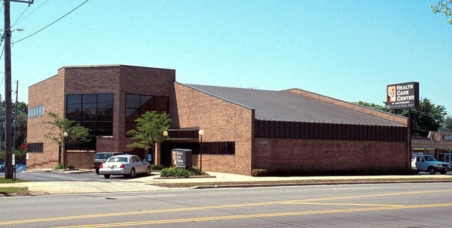

This Property Is For Sale
NEARBY LISTINGS FOR SALE OR LEASE
Property Detail
10215 W Roosevelt Rd
Chicago-Naperville-Elgin, IL-IN-WI
Nixon & Cos Westchester
15-21-501-005-0000
GEO F (NIXON) & COS (WESTCHESTER) IN WH NW SEC 21-39-12
Storebuilding
Cook
X
Illinois
17031C0457J
431,4
2023
0.69 AC
2024
Eastern East/West Corr
818200
Chicago
10,919 SF
DEMOGRAPHICS near 10215 W Roosevelt Rd
1 Mile
3 Mile
5 Mile
2024 Total Population
14,424
128,970
392,601
2029 Population
13,929
124,838
381,821
Pop Growth 2024-2029
(3.43%)
(3.20%)
(2.75%)
Average Age
42
41
41
2024 Total Households
5,350
44,976
144,565
HH Growth 2024-2029
(3.83%)
(3.49%)
(2.97%)
Median Household Inc
$78,853
$73,401
$84,431
Avg Household Size
2.60
2.80
2.60
2024 Avg HH Vehicles
2.00
2.00
2.00
Median Home Value
$235,524
$247,513
$313,516
Median Year Built
1954
1955
1954
Nearby Places
- Restaurants
- Banks
- Shops
- Fitness
- Groceries
PUBLIC TRANSPORTATION
COMMUTER RAIL
Bellwood Station (Union Pacific West Line - Northeast Illinois Regional Commuter Railroad (Metra))
DRIVE
WALK
Distance
Bellwood Station (Union Pacific West Line - Northeast Illinois Regional Commuter Railroad (Metra))
6 min
2.3 mi
Melrose Park Station (Union Pacific West Line - Northeast Illinois Regional Commuter Railroad (Metra))
DRIVE
WALK
Distance
Melrose Park Station (Union Pacific West Line - Northeast Illinois Regional Commuter Railroad (Metra))
7 min
3.3 mi
AIRPORT
Chicago O'Hare International
DRIVE
WALK
Distance
Chicago O'Hare International
21 min
10.5 mi
Chicago Midway International
DRIVE
WALK
Distance
Chicago Midway International
19 min
11.0 mi
Nearby Properties
Address
Land Use
TOTAL SIZE
Lot Size
Zoning
Address
Land Use
TOTAL SIZE
Lot Size
Zoning
221,673 SF
4.49 AC
Address
Land Use
TOTAL SIZE
Lot Size
Zoning
973,922 SF
53.84 AC
I
Address
Land Use
TOTAL SIZE
Lot Size
Zoning
221,111 SF
20.62 AC
Address
Land Use
TOTAL SIZE
Lot Size
Zoning
516,605 SF
16.29 AC
Address
Land Use
TOTAL SIZE
Lot Size
Zoning
98,990 SF
3.52 AC
C
Address
Land Use
TOTAL SIZE
Lot Size
Zoning
250,892 SF
9.04 AC
C
Address
Land Use
TOTAL SIZE
Lot Size
Zoning
6.26 AC
Address
Land Use
TOTAL SIZE
Lot Size
Zoning
128,536 SF
17.06 AC
C
Address
Land Use
TOTAL SIZE
Lot Size
Zoning
128,536 SF
11.24 AC
C
Address
Land Use
TOTAL SIZE
Lot Size
Zoning
389,155 SF
17.69 AC
Address
Land Use
TOTAL SIZE
Lot Size
Zoning
Address
Land Use
TOTAL SIZE
Lot Size
Zoning
479,130 SF
15.80 AC
Address
Land Use
TOTAL SIZE
Lot Size
Zoning
137,144 SF
11.77 AC
Address
Land Use
TOTAL SIZE
Lot Size
Zoning
95,520 SF
9.55 AC
C
Address
Land Use
TOTAL SIZE
Lot Size
Zoning
165,728 SF
2.88 AC
C
Address
Land Use
TOTAL SIZE
Lot Size
Zoning
8.53 AC
Address
Land Use
TOTAL SIZE
Lot Size
Zoning
195,355 SF
8.65 AC
C
Address
Land Use
TOTAL SIZE
Lot Size
Zoning
184,970 SF
11.64 AC
Address
Land Use
TOTAL SIZE
Lot Size
Zoning
1,156,393 SF
6.55 AC
Address
Land Use
TOTAL SIZE
Lot Size
Zoning
6.11 AC
Address
Land Use
TOTAL SIZE
Lot Size
Zoning
108,276 SF
3.80 AC
Address
Land Use
TOTAL SIZE
Lot Size
Zoning
7.16 AC
Address
Land Use
TOTAL SIZE
Lot Size
Zoning
8.01 AC
Address
Land Use
TOTAL SIZE
Lot Size
Zoning
609,109 SF
12.10 AC
Address
Land Use
TOTAL SIZE
Lot Size
Zoning
1.65 AC
Address
Land Use
TOTAL SIZE
Lot Size
Zoning
101,146 SF
2.24 AC
Address
Land Use
TOTAL SIZE
Lot Size
Zoning
320,928 SF
13.46 AC
Address
Land Use
TOTAL SIZE
Lot Size
Zoning
193,511 SF
17.89 AC
Address
Land Use
TOTAL SIZE
Lot Size
Zoning
125,628 SF
4.18 AC
B-1
Address
Land Use
TOTAL SIZE
Lot Size
Zoning
103,050 SF
7.49 AC
The World's #1 Commercial Real Estate Marketplace
Connect with us
© 2025 CoStar Group
The information above has been obtained from sources believed reliable. While we do not doubt its accuracy we have not verified it and make no guarantee, warranty or representation about it. It is your responsibility to independently confirm its accuracy and completeness. Any projections, opinions, assumptions, or estimates used are for example only and do not represent the current or future performance of the property. The value of this transaction to you depends on tax and other factors which should be evaluated by your tax, financial, and legal advisors. You and your advisors should conduct a careful, independent investigation of the property to determine to your satisfaction the suitability of the property for your needs.