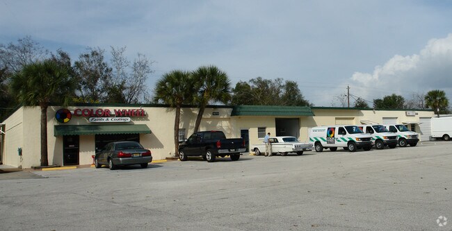
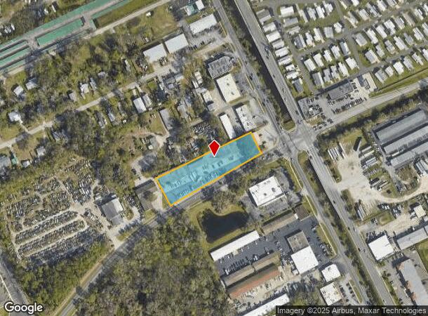
Property Record
1038 Reed Canal Rd, Daytona Beach, FL 32119

NEARBY LISTINGS FOR SALE OR LEASE
Property Detail
1038 Reed Canal Rd
Deltona-Daytona Beach-Ormond Beach, FL
Halifax
5344-16-00-1381
S 185 FT OF W 508 FT OF E 642 FT OF LOT 138 W OF HALIFAX DRAINAGE CANAL R/W BLAKE & EXC W 480.9 FT OF E 563.9 FT OF S 26.4 FT MEAS ON E/L & BEING 7.36 FT ON W/L & EXC NEW R/W FOR REED CANAL RD IN S 33.48 FT ON W/L & S 48.66 FT ON E/L PER OR 1613 PG 0
Lightindustrial
Volusia
X
Florida
12127C0369J
138
2025
1.52 AC
2025
South Daytona Beach
082414
Deltona/Daytona Beach
24,899 SF
DEMOGRAPHICS near 1038 Reed Canal Rd
1 Mile
3 Mile
5 Mile
2024 Total Population
10,678
72,341
134,799
2029 Population
11,894
80,127
149,917
Pop Growth 2024-2029
+ 11.39%
+ 10.76%
+ 11.22%
Average Age
49
45
44
2024 Total Households
5,328
32,774
60,100
HH Growth 2024-2029
+ 11.71%
+ 11.25%
+ 11.68%
Median Household Inc
$45,513
$49,263
$49,483
Avg Household Size
2.00
2.10
2.10
2024 Avg HH Vehicles
2.00
2.00
2.00
Median Home Value
$111,303
$204,230
$222,849
Median Year Built
1984
1982
1982
Nearby Places
- Restaurants
- Banks
- Shops
- Fitness
- Groceries
PUBLIC TRANSPORTATION
AIRPORT
Daytona Beach International
DRIVE
WALK
Distance
Daytona Beach International
10 min
4.8 mi
Orlando Sanford International
DRIVE
WALK
Distance
Orlando Sanford International
56 min
39.5 mi
SALE & LEASE HISTORY
LISTING DATE
SALE/LEASE

Aug 06, 2024
For Lease
Nearby Properties
Address
Land Use
TOTAL SIZE
Lot Size
Zoning
Address
Land Use
TOTAL SIZE
Lot Size
Zoning
1,842,969 SF
25.56 AC
Address
Land Use
TOTAL SIZE
Lot Size
Zoning
442,125 SF
0.98 AC
A21
Address
Land Use
TOTAL SIZE
Lot Size
Zoning
490,775 SF
34.26 AC
01MH1
Address
Land Use
TOTAL SIZE
Lot Size
Zoning
396,385 SF
10 AC
01A2
Address
Land Use
TOTAL SIZE
Lot Size
Zoning
448,867 SF
5.54 AC
Address
Land Use
TOTAL SIZE
Lot Size
Zoning
13,965 SF
0.70 AC
MH1
Address
Land Use
TOTAL SIZE
Lot Size
Zoning
330,883 SF
19.59 AC
Address
Land Use
TOTAL SIZE
Lot Size
Zoning
325,744 SF
12.23 AC
Address
Land Use
TOTAL SIZE
Lot Size
Zoning
269,133 SF
6.33 AC
Address
Land Use
TOTAL SIZE
Lot Size
Zoning
300,516 SF
70 AC
A2
Address
Land Use
TOTAL SIZE
Lot Size
Zoning
226,459 SF
0.57 AC
Address
Land Use
TOTAL SIZE
Lot Size
Zoning
379,591 SF
21.62 AC
MH1
Address
Land Use
TOTAL SIZE
Lot Size
Zoning
306,467 SF
20.76 AC
Address
Land Use
TOTAL SIZE
Lot Size
Zoning
10,360 SF
1.56 AC
Address
Land Use
TOTAL SIZE
Lot Size
Zoning
324,364 SF
11.59 AC
02RPUD
Address
Land Use
TOTAL SIZE
Lot Size
Zoning
12,871 SF
0.20 AC
R4
Address
Land Use
TOTAL SIZE
Lot Size
Zoning
5,774 SF
0.94 AC
B4
Address
Land Use
TOTAL SIZE
Lot Size
Zoning
150,197 SF
16.07 AC
Address
Land Use
TOTAL SIZE
Lot Size
Zoning
94,338 SF
7.39 AC
Address
Land Use
TOTAL SIZE
Lot Size
Zoning
412,064 SF
60 AC
Address
Land Use
TOTAL SIZE
Lot Size
Zoning
184,242 SF
14.43 AC
Address
Land Use
TOTAL SIZE
Lot Size
Zoning
92,927 SF
14.58 AC
Address
Land Use
TOTAL SIZE
Lot Size
Zoning
185,175 SF
7.50 AC
Address
Land Use
TOTAL SIZE
Lot Size
Zoning
9,952 SF
9.30 AC
16RMH
Address
Land Use
TOTAL SIZE
Lot Size
Zoning
201,947 SF
0.23 AC
Address
Land Use
TOTAL SIZE
Lot Size
Zoning
185,278 SF
15.85 AC
Address
Land Use
TOTAL SIZE
Lot Size
Zoning
175,132 SF
5 AC
Address
Land Use
TOTAL SIZE
Lot Size
Zoning
156,994 SF
47.82 AC
16A
Address
Land Use
TOTAL SIZE
Lot Size
Zoning
155,590 SF
11.08 AC
16R3H
Address
Land Use
TOTAL SIZE
Lot Size
Zoning
146,580 SF
2.80 AC
02R3
The World's #1 Commercial Real Estate Marketplace
Connect with us
© 2025 CoStar Group
The information above has been obtained from sources believed reliable. While we do not doubt its accuracy we have not verified it and make no guarantee, warranty or representation about it. It is your responsibility to independently confirm its accuracy and completeness. Any projections, opinions, assumptions, or estimates used are for example only and do not represent the current or future performance of the property. The value of this transaction to you depends on tax and other factors which should be evaluated by your tax, financial, and legal advisors. You and your advisors should conduct a careful, independent investigation of the property to determine to your satisfaction the suitability of the property for your needs.