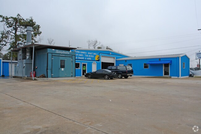
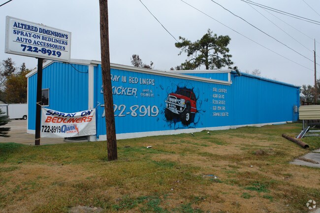
Property Record
1022 Magnolia Ave, Port Neches, TX 77651
NEARBY LISTINGS FOR SALE OR LEASE
Property Detail
1022 Magnolia Ave
Beaumont/Port Arthur
Central
Beaumont-Port Arthur, TX
Jefferson
011700-000-023000-00000
Texas
Commercialnec
0.43 AC
9,835 SF
Port Arthur
DEMOGRAPHICS near 1022 Magnolia Ave
1 Mile
3 Mile
5 Mile
2024 Total Population
7,666
37,641
73,374
2029 Population
7,326
36,191
70,933
Pop Growth 2024-2029
(4.44%)
(3.85%)
(3.33%)
Average Age
40
39
39
2024 Total Households
3,016
15,367
27,334
HH Growth 2024-2029
(4.51%)
(4.02%)
(3.60%)
Median Household Inc
$91,189
$71,443
$70,363
Avg Household Size
2.50
2.40
2.50
2024 Avg HH Vehicles
2.00
2.00
2.00
Median Home Value
$196,824
$181,772
$176,386
Median Year Built
1968
1973
1973
Nearby Places
Map Layers
Map Styles
 Street
 Aerial
- Restaurants
- Banks
- Shops
- Fitness
- Groceries
Nearby Properties
Address
Land Use
TOTAL SIZE
Lot Size
Zoning
Address
Land Use
TOTAL SIZE
Lot Size
Zoning
279,375 SF
18.94 AC
Address
Land Use
TOTAL SIZE
Lot Size
Zoning
157,411 SF
38.21 AC
Address
Land Use
TOTAL SIZE
Lot Size
Zoning
136,295 SF
5.30 AC
Address
Land Use
TOTAL SIZE
Lot Size
Zoning
47,841 SF
8 AC
Address
Land Use
TOTAL SIZE
Lot Size
Zoning
7,296 SF
59.41 AC
Address
Land Use
TOTAL SIZE
Lot Size
Zoning
63,836 SF
0.64 AC
Address
Land Use
TOTAL SIZE
Lot Size
Zoning
129,495 SF
7.23 AC
Address
Land Use
TOTAL SIZE
Lot Size
Zoning
127,946 SF
7.72 AC
Address
Land Use
TOTAL SIZE
Lot Size
Zoning
303,400 SF
14.15 AC
Address
Land Use
TOTAL SIZE
Lot Size
Zoning
628,811 SF
38.48 AC
Address
Land Use
TOTAL SIZE
Lot Size
Zoning
79,096 SF
9.09 AC
Address
Land Use
TOTAL SIZE
Lot Size
Zoning
185,832 SF
10.08 AC
Address
Land Use
TOTAL SIZE
Lot Size
Zoning
55,953 SF
1.87 AC
Address
Land Use
TOTAL SIZE
Lot Size
Zoning
62,233 SF
6.94 AC
Address
Land Use
TOTAL SIZE
Lot Size
Zoning
121,752 SF
9.88 AC
Address
Land Use
TOTAL SIZE
Lot Size
Zoning
713.58 AC
Address
Land Use
TOTAL SIZE
Lot Size
Zoning
45,252 SF
13.70 AC
Address
Land Use
TOTAL SIZE
Lot Size
Zoning
89,093 SF
10.51 AC
Address
Land Use
TOTAL SIZE
Lot Size
Zoning
135,891 SF
9.95 AC
Address
Land Use
TOTAL SIZE
Lot Size
Zoning
243,132 SF
21.67 AC
Address
Land Use
TOTAL SIZE
Lot Size
Zoning
155,734 SF
11.27 AC
Address
Land Use
TOTAL SIZE
Lot Size
Zoning
157,343 SF
9.09 AC
Address
Land Use
TOTAL SIZE
Lot Size
Zoning
75,879 SF
3.58 AC
Address
Land Use
TOTAL SIZE
Lot Size
Zoning
134,498 SF
8.26 AC
Address
Land Use
TOTAL SIZE
Lot Size
Zoning
70,361 SF
3.66 AC
Address
Land Use
TOTAL SIZE
Lot Size
Zoning
146,251 SF
9.08 AC
Address
Land Use
TOTAL SIZE
Lot Size
Zoning
87,616 SF
9.96 AC
Address
Land Use
TOTAL SIZE
Lot Size
Zoning
182,506 SF
10.20 AC
Address
Land Use
TOTAL SIZE
Lot Size
Zoning
108,007 SF
10.49 AC
Address
Land Use
TOTAL SIZE
Lot Size
Zoning
25,108 SF
1.03 AC
The World's #1 Commercial Real Estate Marketplace
Connect with us
© 2025 CoStar Group
The information above has been obtained from sources believed reliable. While we do not doubt its accuracy we have not verified it and make no guarantee, warranty or representation about it. It is your responsibility to independently confirm its accuracy and completeness. Any projections, opinions, assumptions, or estimates used are for example only and do not represent the current or future performance of the property. The value of this transaction to you depends on tax and other factors which should be evaluated by your tax, financial, and legal advisors. You and your advisors should conduct a careful, independent investigation of the property to determine to your satisfaction the suitability of the property for your needs.