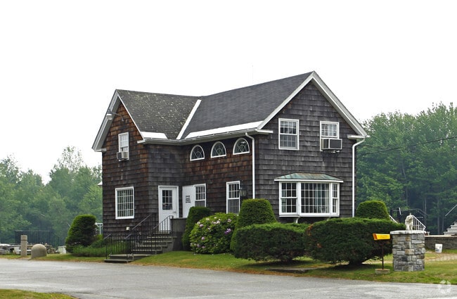
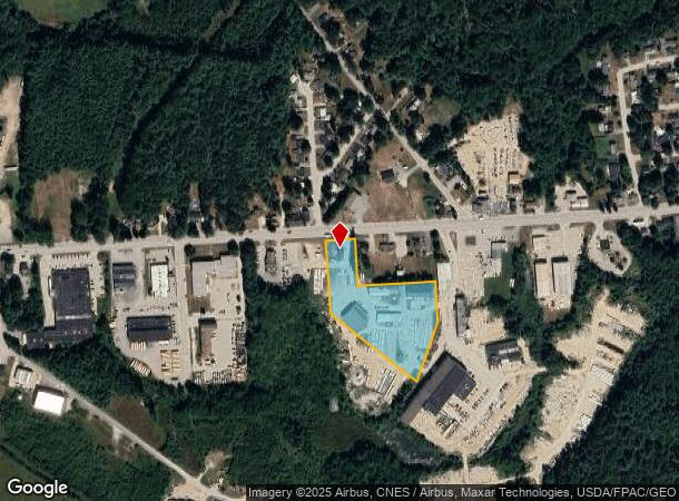
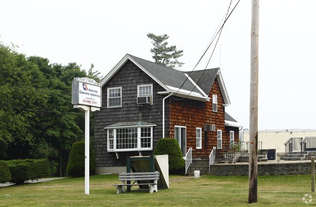
Property Record
1022 Minot Ave, Auburn, ME 04210
NEARBY LISTINGS FOR SALE OR LEASE
Property Detail
1022 Minot Ave
Industrialgeneral
Androscoggin
X
Maine
23001C0309E
48
2024
33.36 AC
2024
Other Market Areas
010700
Lewiston-Auburn, ME
33,662 SF
AUBN-000206-000000-000048
DEMOGRAPHICS near 1022 Minot Ave
1 Mile
3 Mile
5 Mile
2024 Total Population
1,877
20,973
53,858
2029 Population
1,903
21,206
54,537
Pop Growth 2024-2029
+ 1.39%
+ 1.11%
+ 1.26%
Average Age
45
42
40
2024 Total Households
794
8,811
22,128
HH Growth 2024-2029
+ 1.51%
+ 1.15%
+ 1.19%
Median Household Inc
$77,361
$52,867
$49,208
Avg Household Size
2.30
2.20
2.20
2024 Avg HH Vehicles
2.00
2.00
1.00
Median Home Value
$219,892
$225,935
$210,051
Median Year Built
1957
1949
1952
Nearby Places
Map Layers
Map Styles
 Street
 Aerial
- Restaurants
- Banks
- Shops
- Fitness
- Groceries
Nearby Properties
Address
Land Use
TOTAL SIZE
Lot Size
Zoning
Address
Land Use
TOTAL SIZE
Lot Size
Zoning
601,694 SF
62.88 AC
Address
Land Use
TOTAL SIZE
Lot Size
Zoning
290,822 SF
61.58 AC
Address
Land Use
TOTAL SIZE
Lot Size
Zoning
Address
Land Use
TOTAL SIZE
Lot Size
Zoning
34,797 SF
10.98 AC
Address
Land Use
TOTAL SIZE
Lot Size
Zoning
511,690 SF
139.18 AC
Address
Land Use
TOTAL SIZE
Lot Size
Zoning
90,085 SF
1.49 AC
Address
Land Use
TOTAL SIZE
Lot Size
Zoning
210,388 SF
1.46 AC
Address
Land Use
TOTAL SIZE
Lot Size
Zoning
76,915 SF
1.83 AC
Address
Land Use
TOTAL SIZE
Lot Size
Zoning
129,113 SF
7.50 AC
Address
Land Use
TOTAL SIZE
Lot Size
Zoning
3,027 SF
13.19 AC
Address
Land Use
TOTAL SIZE
Lot Size
Zoning
93,949 SF
1.40 AC
Address
Land Use
TOTAL SIZE
Lot Size
Zoning
185,466 SF
0.97 AC
Address
Land Use
TOTAL SIZE
Lot Size
Zoning
153,752 SF
132.60 AC
Address
Land Use
TOTAL SIZE
Lot Size
Zoning
82,748 SF
26.27 AC
Address
Land Use
TOTAL SIZE
Lot Size
Zoning
278,946 SF
16.83 AC
Address
Land Use
TOTAL SIZE
Lot Size
Zoning
53,352 SF
1.02 AC
Address
Land Use
TOTAL SIZE
Lot Size
Zoning
41,771 SF
17.10 AC
Address
Land Use
TOTAL SIZE
Lot Size
Zoning
53,768 SF
11.72 AC
Address
Land Use
TOTAL SIZE
Lot Size
Zoning
71,000 SF
10.02 AC
Address
Land Use
TOTAL SIZE
Lot Size
Zoning
51,280 SF
0.82 AC
Address
Land Use
TOTAL SIZE
Lot Size
Zoning
35,760 SF
104.20 AC
Address
Land Use
TOTAL SIZE
Lot Size
Zoning
37,802 SF
1.19 AC
Address
Land Use
TOTAL SIZE
Lot Size
Zoning
101,876 SF
12.42 AC
Address
Land Use
TOTAL SIZE
Lot Size
Zoning
142,868 SF
39.52 AC
Address
Land Use
TOTAL SIZE
Lot Size
Zoning
37,835 SF
2,071.44 AC
Address
Land Use
TOTAL SIZE
Lot Size
Zoning
56,250 SF
0.56 AC
Address
Land Use
TOTAL SIZE
Lot Size
Zoning
250,776 SF
2.57 AC
Address
Land Use
TOTAL SIZE
Lot Size
Zoning
68,094 SF
26.82 AC
Address
Land Use
TOTAL SIZE
Lot Size
Zoning
38,850 SF
0.76 AC
Address
Land Use
TOTAL SIZE
Lot Size
Zoning
7.54 AC
The World's #1 Commercial Real Estate Marketplace
Connect with us
© 2025 CoStar Group
The information above has been obtained from sources believed reliable. While we do not doubt its accuracy we have not verified it and make no guarantee, warranty or representation about it. It is your responsibility to independently confirm its accuracy and completeness. Any projections, opinions, assumptions, or estimates used are for example only and do not represent the current or future performance of the property. The value of this transaction to you depends on tax and other factors which should be evaluated by your tax, financial, and legal advisors. You and your advisors should conduct a careful, independent investigation of the property to determine to your satisfaction the suitability of the property for your needs.