Property Record
10220 Route 1 Way, North Chesterfield, VA 23237
NEARBY LISTINGS FOR SALE OR LEASE
-
-
View all North Chesterfield listings for sale on LoopNet.com
Property Detail
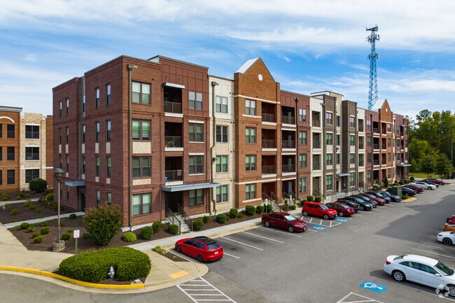
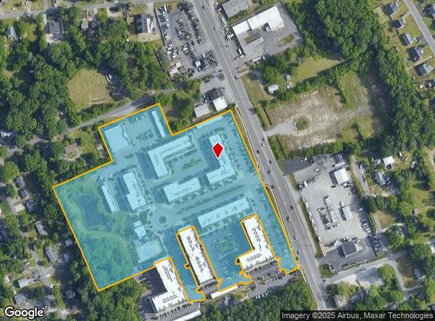
10220 Route 1 Way
794-66-66-71-900-000
W/L Jefferson Davis Highway
Apartment
W/L JEFFERSON DAVIS HIGHWAY
X
Chesterfield
5101290100E
Virginia
0
11.82 AC
2025
Chesterfield County
100407
Richmond VA
55,952 SF
Richmond, VA
DEMOGRAPHICS near 10220 Route 1 Way
1 Mile
3 Mile
5 Mile
2024 Total Population
4,543
32,738
94,980
2029 Population
4,984
35,903
103,932
Pop Growth 2024-2029
+ 9.71%
+ 9.67%
+ 9.43%
Average Age
38
40
39
2024 Total Households
1,769
12,857
35,400
HH Growth 2024-2029
+ 9.84%
+ 9.82%
+ 9.57%
Median Household Inc
$61,303
$66,955
$68,898
Avg Household Size
2.50
2.50
2.60
2024 Avg HH Vehicles
2.00
2.00
2.00
Median Home Value
$247,993
$257,305
$263,279
Median Year Built
1988
1987
1987
Nearby Places
Map Layers
Map Styles
 Street
 Aerial
- Restaurants
- Banks
- Shops
- Fitness
- Groceries
PUBLIC TRANSPORTATION
AIRPORT
Richmond International
DRIVE
WALK
Distance
Richmond International
24 min
15.2 mi
Freight Ports
Virginia Port Authority - Richmond
DRIVE
WALK
Distance
Virginia Port Authority - Richmond
13 min
7.5 mi
Nearby Properties
Address
Land Use
TOTAL SIZE
Lot Size
Zoning
Address
Land Use
TOTAL SIZE
Lot Size
Zoning
100 SF
652.52 AC
A - AGRICU
Address
Land Use
TOTAL SIZE
Lot Size
Zoning
437,024 SF
39.40 AC
I3 - HVY I
Address
Land Use
TOTAL SIZE
Lot Size
Zoning
406,110 SF
57.69 AC
I3 - HVY I
Address
Land Use
TOTAL SIZE
Lot Size
Zoning
32,947 SF
13.38 AC
C5 - GEN B
Address
Land Use
TOTAL SIZE
Lot Size
Zoning
289,964 SF
39.62 AC
R7 - SINGL
Address
Land Use
TOTAL SIZE
Lot Size
Zoning
1.60 AC
RMF - RES,
Address
Land Use
TOTAL SIZE
Lot Size
Zoning
100 SF
36.88 AC
RMF - RES,
Address
Land Use
TOTAL SIZE
Lot Size
Zoning
177,908 SF
13.59 AC
RMF - RES,
Address
Land Use
TOTAL SIZE
Lot Size
Zoning
320,853 SF
33.68 AC
I3 - HVY I
Address
Land Use
TOTAL SIZE
Lot Size
Zoning
220,825 SF
55.17 AC
I3 - HVY I
Address
Land Use
TOTAL SIZE
Lot Size
Zoning
406,490 SF
19.58 AC
I3 - HVY I
Address
Land Use
TOTAL SIZE
Lot Size
Zoning
406,490 SF
33.22 AC
I3 - HVY I
Address
Land Use
TOTAL SIZE
Lot Size
Zoning
67,060 SF
4.93 AC
C5 - GEN B
Address
Land Use
TOTAL SIZE
Lot Size
Zoning
70,882 SF
20.08 AC
C3 - COMMU
Address
Land Use
TOTAL SIZE
Lot Size
Zoning
29,808 SF
5.63 AC
C3 - COMMU
Address
Land Use
TOTAL SIZE
Lot Size
Zoning
86,109 SF
29.94 AC
C3 - COMMU
Address
Land Use
TOTAL SIZE
Lot Size
Zoning
318,611 SF
24.17 AC
I3 - HVY I
Address
Land Use
TOTAL SIZE
Lot Size
Zoning
78,429 SF
23.53 AC
RMF - RES,
Address
Land Use
TOTAL SIZE
Lot Size
Zoning
15,600 SF
3.97 AC
C3 - COMMU
Address
Land Use
TOTAL SIZE
Lot Size
Zoning
147,276 SF
27.04 AC
R7 - SINGL
Address
Land Use
TOTAL SIZE
Lot Size
Zoning
138,860 SF
23.68 AC
RMF - RES,
Address
Land Use
TOTAL SIZE
Lot Size
Zoning
13,567 SF
17.96 AC
C5 - GEN B
Address
Land Use
TOTAL SIZE
Lot Size
Zoning
324,530 SF
31.47 AC
I3 - HVY I
Address
Land Use
TOTAL SIZE
Lot Size
Zoning
53,655 SF
19.01 AC
C3 - COMMU
Address
Land Use
TOTAL SIZE
Lot Size
Zoning
12.69 AC
R7 - SINGL
Address
Land Use
TOTAL SIZE
Lot Size
Zoning
73,969 SF
27.42 AC
A - AGRICU
Address
Land Use
TOTAL SIZE
Lot Size
Zoning
24,929 SF
6.03 AC
C3 - COMMU
Address
Land Use
TOTAL SIZE
Lot Size
Zoning
161,915 SF
21.43 AC
I3 - HVY I
Address
Land Use
TOTAL SIZE
Lot Size
Zoning
83,480 SF
3.54 AC
C5 - GEN B
The World's #1 Commercial Real Estate Marketplace
Connect with us
© 2025 CoStar Group
The information above has been obtained from sources believed reliable. While we do not doubt its accuracy we have not verified it and make no guarantee, warranty or representation about it. It is your responsibility to independently confirm its accuracy and completeness. Any projections, opinions, assumptions, or estimates used are for example only and do not represent the current or future performance of the property. The value of this transaction to you depends on tax and other factors which should be evaluated by your tax, financial, and legal advisors. You and your advisors should conduct a careful, independent investigation of the property to determine to your satisfaction the suitability of the property for your needs.