Property Record
10221 New Kings Rd, Jacksonville, FL 32219
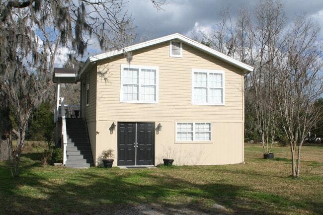
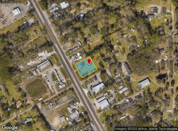
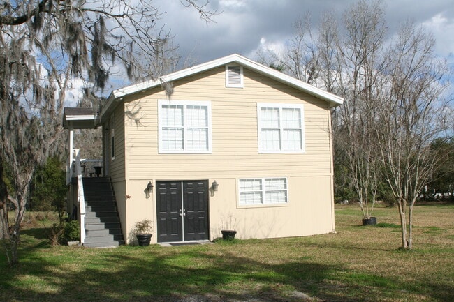
This Property Is For Sale
NEARBY LISTINGS FOR SALE OR LEASE
Property Detail
10221 New Kings Rd
002688-0000
Section Land
Officebuilding
13-1S-25E .91 PT NE1/4 RECD O/R 9628-814
X
Duval
12031C0167J
Florida
2025
0.80 AC
2026
Northwest Jacksonville
010502
Jacksonville (Florida)
1,600 SF
Jacksonville, FL
DEMOGRAPHICS near 10221 New Kings Rd
1 Mile
3 Mile
5 Mile
2024 Total Population
2,117
30,347
75,714
2029 Population
2,247
32,004
79,993
Pop Growth 2024-2029
+ 6.14%
+ 5.46%
+ 5.65%
Average Age
39
40
40
2024 Total Households
763
11,245
28,287
HH Growth 2024-2029
+ 6.16%
+ 5.50%
+ 5.71%
Median Household Inc
$71,940
$56,053
$50,462
Avg Household Size
2.70
2.60
2.60
2024 Avg HH Vehicles
2.00
2.00
2.00
Median Home Value
$158,928
$176,759
$165,574
Median Year Built
1994
1984
1976
Nearby Places
Map Layers
Map Styles
 Street
 Aerial
- Restaurants
- Banks
- Shops
- Fitness
- Groceries
PUBLIC TRANSPORTATION
COMMUTER RAIL
DRIVE
WALK
Distance
9 min
4.4 mi
AIRPORT
Jacksonville International
DRIVE
WALK
Distance
Jacksonville International
19 min
10.8 mi
Freight Ports
Jacksonville Port
DRIVE
WALK
Distance
Jacksonville Port
19 min
10.6 mi
Nearby Properties
Address
Land Use
TOTAL SIZE
Lot Size
Zoning
Address
Land Use
TOTAL SIZE
Lot Size
Zoning
647,378 SF
27.72 AC
IBP
Address
Land Use
TOTAL SIZE
Lot Size
Zoning
449,967 SF
23.08 AC
IL
Address
Land Use
TOTAL SIZE
Lot Size
Zoning
375,130 SF
25.22 AC
IBP
Address
Land Use
TOTAL SIZE
Lot Size
Zoning
302,066 SF
15.70 AC
IL
Address
Land Use
TOTAL SIZE
Lot Size
Zoning
6,300 SF
744.81 AC
PUD
Address
Land Use
TOTAL SIZE
Lot Size
Zoning
277,582 SF
16.49 AC
IL
Address
Land Use
TOTAL SIZE
Lot Size
Zoning
225,829 SF
140.47 AC
PBF-1
Address
Land Use
TOTAL SIZE
Lot Size
Zoning
39,251 SF
55.24 AC
PUD
Address
Land Use
TOTAL SIZE
Lot Size
Zoning
176,798 SF
14.77 AC
PUD
Address
Land Use
TOTAL SIZE
Lot Size
Zoning
178,080 SF
9.34 AC
IL
Address
Land Use
TOTAL SIZE
Lot Size
Zoning
80,622 SF
78.47 AC
PUD
Address
Land Use
TOTAL SIZE
Lot Size
Zoning
95,080 SF
9.35 AC
CRO
Address
Land Use
TOTAL SIZE
Lot Size
Zoning
157,948 SF
9.02 AC
PUD
Address
Land Use
TOTAL SIZE
Lot Size
Zoning
79,407 SF
14.93 AC
PUD
Address
Land Use
TOTAL SIZE
Lot Size
Zoning
49,120 SF
89.32 AC
CCG-2
Address
Land Use
TOTAL SIZE
Lot Size
Zoning
1,688 SF
99.78 AC
IH
Address
Land Use
TOTAL SIZE
Lot Size
Zoning
1,950 SF
72.15 AC
IBP
Address
Land Use
TOTAL SIZE
Lot Size
Zoning
74,680 SF
5.07 AC
PUD
Address
Land Use
TOTAL SIZE
Lot Size
Zoning
17,698 SF
2.11 AC
CCG-1
Address
Land Use
TOTAL SIZE
Lot Size
Zoning
67,409 SF
12.53 AC
PUD
Address
Land Use
TOTAL SIZE
Lot Size
Zoning
66,255 SF
40.55 AC
RR-ACRE
Address
Land Use
TOTAL SIZE
Lot Size
Zoning
58.58 AC
IH
Address
Land Use
TOTAL SIZE
Lot Size
Zoning
13,214 SF
1.52 AC
PUD
Address
Land Use
TOTAL SIZE
Lot Size
Zoning
58,475 SF
5.33 AC
PUD
Address
Land Use
TOTAL SIZE
Lot Size
Zoning
16,030 SF
0.06 AC
CCG-1
Address
Land Use
TOTAL SIZE
Lot Size
Zoning
792 SF
9.18 AC
ROS
Address
Land Use
TOTAL SIZE
Lot Size
Zoning
49,970 SF
6.32 AC
CN
Address
Land Use
TOTAL SIZE
Lot Size
Zoning
16,110 SF
0.06 AC
CCG-1
Address
Land Use
TOTAL SIZE
Lot Size
Zoning
37,790 SF
25.22 AC
RMD-A
Address
Land Use
TOTAL SIZE
Lot Size
Zoning
55,546 SF
17.58 AC
IH
The World's #1 Commercial Real Estate Marketplace
Connect with us
© 2026 CoStar Group
The information above has been obtained from sources believed reliable. While we do not doubt its accuracy we have not verified it and make no guarantee, warranty or representation about it. It is your responsibility to independently confirm its accuracy and completeness. Any projections, opinions, assumptions, or estimates used are for example only and do not represent the current or future performance of the property. The value of this transaction to you depends on tax and other factors which should be evaluated by your tax, financial, and legal advisors. You and your advisors should conduct a careful, independent investigation of the property to determine to your satisfaction the suitability of the property for your needs.