Property Record
10225 Carnoch Way, Bristow, VA 20136
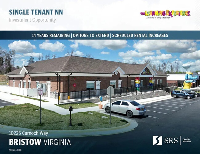

Property Detail
10225 Carnoch Way
Washington-Arlington-Alexandria, DC-VA-MD-WV
BRAEMAR PUBLIC-COMMERCIAL AREAS L 5A2B
7495-51-1366
Prince William
Daycare
Virginia
RPC
5
2024
1.40 AC
2025
Route 29/I-66 Corridor
901414
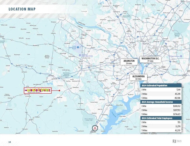
Washington, DC
10,000 SF
NEARBY LISTINGS FOR SALE OR LEASE
DEMOGRAPHICS near 10225 Carnoch Way
1 mile
3 mile
5 mile
2025 Total Population
7,292
43,069
83,476
2030 Population
7,430
44,107
85,614
Pop Growth 2025-2030
+ 1.89%
+ 2.41%
+ 2.56%
Average Age
38
36
37
2025 Total Households
2,298
12,584
26,271
HH Growth 2025-2030
+ 1.74%
+ 2.35%
+ 2.57%
Median Household Inc
$173,822
$175,711
$146,673
Avg Household Size
3.20
3.30
3.10
2025 Avg HH Vehicles
2.00
2.00
2.00
Median Home Value
$641,868
$680,841
$647,258
Median Year Built
2003
2004
2000
Nearby Places
Map Layers
Map Styles
 Street
 Aerial
Layers
 Traffic
 Biking
Places
Listings with unknown addresses are not visible on the map
- Restaurants
- Banks
- Shops
- Fitness
- Groceries
PUBLIC TRANSPORTATION
COMMUTER RAIL
Lead (Manassas Line - Virginia Railway Express)
Drive
Walk
Distance
Lead (Manassas Line - Virginia Railway Express)
10 min
4.8 mi
Manassas Amtrak Station (Cardinal - Amtrak, Crescent - Amtrak, Manassas Line - Amtrak, Northeast Regional - Amtrak)
Drive
Walk
Distance
Manassas Amtrak Station (Cardinal - Amtrak, Crescent - Amtrak, Manassas Line - Amtrak, Northeast Regional - Amtrak)
14 min
6.9 mi
AIRPORT
Washington Dulles International
Drive
Walk
Distance
Washington Dulles International
40 min
24.3 mi
Freight Ports
Port of Baltimore
Drive
Walk
Distance
Port of Baltimore
99 min
74.7 mi
SALE & LEASE HISTORY
LISTING DATE
SALE/LEASE

Oct 16, 2024
For Sale
Jan 26, 2024
For Sale
Apr 25, 2025
For Sale
Nearby Properties
Address
Land Use
TOTAL SIZE
Lot Size
Zoning
Address
Land Use
TOTAL SIZE
Lot Size
Zoning
224,652 SF
12.05 AC
PBD
Address
Land Use
TOTAL SIZE
Lot Size
Zoning
241,249 SF
12.58 AC
PBD
Address
Land Use
TOTAL SIZE
Lot Size
Zoning
281,000 SF
10.08 AC
PBD
Address
Land Use
TOTAL SIZE
Lot Size
Zoning
259,200 SF
14.22 AC
PBD
Address
Land Use
TOTAL SIZE
Lot Size
Zoning
112.48 AC
M2
Address
Land Use
TOTAL SIZE
Lot Size
Zoning
247,608 SF
19.50 AC
PBD
Address
Land Use
TOTAL SIZE
Lot Size
Zoning
352,030 SF
21.14 AC
PBD
Address
Land Use
TOTAL SIZE
Lot Size
Zoning
67.20 AC
M2
Address
Land Use
TOTAL SIZE
Lot Size
Zoning
446,663 SF
92.79 AC
A1
Address
Land Use
TOTAL SIZE
Lot Size
Zoning
395,617 SF
19.08 AC
PMD
Address
Land Use
TOTAL SIZE
Lot Size
Zoning
335,553 SF
45.93 AC
M2
Address
Land Use
TOTAL SIZE
Lot Size
Zoning
119.30 AC
M2
Address
Land Use
TOTAL SIZE
Lot Size
Zoning
34.66 AC
PBD
Address
Land Use
TOTAL SIZE
Lot Size
Zoning
185,803 SF
20.77 AC
PBD
Address
Land Use
TOTAL SIZE
Lot Size
Zoning
28.58 AC
M1
Address
Land Use
TOTAL SIZE
Lot Size
Zoning
49.76 AC
PBD
Address
Land Use
TOTAL SIZE
Lot Size
Zoning
85.01 AC
M2
Address
Land Use
TOTAL SIZE
Lot Size
Zoning
16.44 AC
PBD
Address
Land Use
TOTAL SIZE
Lot Size
Zoning
65.55 AC
M2
Address
Land Use
TOTAL SIZE
Lot Size
Zoning
367,927 SF
10.02 AC
PBD
Address
Land Use
TOTAL SIZE
Lot Size
Zoning
19.23 AC
PBD
Address
Land Use
TOTAL SIZE
Lot Size
Zoning
135,706 SF
18.91 AC
B1
Address
Land Use
TOTAL SIZE
Lot Size
Zoning
138,078 SF
10.99 AC
M1
Address
Land Use
TOTAL SIZE
Lot Size
Zoning
138,407 SF
9.63 AC
RPC
Address
Land Use
TOTAL SIZE
Lot Size
Zoning
107,145 SF
20.80 AC
A1
Address
Land Use
TOTAL SIZE
Lot Size
Zoning
104,765 SF
20.97 AC
A1
Address
Land Use
TOTAL SIZE
Lot Size
Zoning
88,741 SF
21.13 AC
A1
Address
Land Use
TOTAL SIZE
Lot Size
Zoning
Address
Land Use
TOTAL SIZE
Lot Size
Zoning
103,176 SF
7.68 AC
M1
Address
Land Use
TOTAL SIZE
Lot Size
Zoning
55,659 SF
47.97 AC
M2
The World's #1 Commercial Real Estate Marketplace
Connect with us
© 2026 CoStar Group
The information above has been obtained from sources believed reliable. While we do not doubt its accuracy we have not verified it and make no guarantee, warranty or representation about it. It is your responsibility to independently confirm its accuracy and completeness. Any projections, opinions, assumptions, or estimates used are for example only and do not represent the current or future performance of the property. The value of this transaction to you depends on tax and other factors which should be evaluated by your tax, financial, and legal advisors. You and your advisors should conduct a careful, independent investigation of the property to determine to your satisfaction the suitability of the property for your needs.