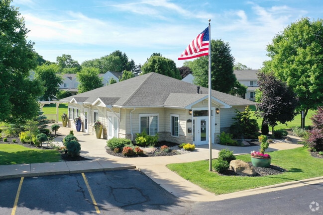
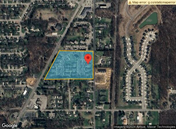
Property Record
10229 Shaver Rd, Portage, MI 49024
NEARBY LISTINGS FOR SALE OR LEASE
-
-
View all Portage listings for sale on LoopNet.com
Property Detail
10229 Shaver Rd
Kalamazoo-Portage, MI
Legan Plat
10-04320-001-A
LEGAN PLAT LOTS 1 THRU 17, EXC NLY 110 FT
Commercialnec
Kalamazoo
X
Michigan
26077C0311E
1-17
2025
10.24 AC
2025
Portage
002005
West Michigan
9,246 SF
DEMOGRAPHICS near 10229 Shaver Rd
1 Mile
3 Mile
5 Mile
2024 Total Population
2,233
19,634
57,616
2029 Population
2,232
19,608
57,337
Pop Growth 2024-2029
(0.04%)
(0.13%)
(0.48%)
Average Age
40
41
40
2024 Total Households
904
8,188
23,121
HH Growth 2024-2029
0.00%
(0.07%)
(0.51%)
Median Household Inc
$87,919
$79,396
$77,793
Avg Household Size
2.40
2.40
2.40
2024 Avg HH Vehicles
2.00
2.00
2.00
Median Home Value
$225,636
$254,725
$244,211
Median Year Built
1981
1979
1980
Nearby Places
Map Layers
Map Styles
 Street
 Aerial
- Restaurants
- Banks
- Shops
- Fitness
- Groceries
PUBLIC TRANSPORTATION
COMMUTER RAIL
Kalamazoo (Blue Water - Amtrak, Wolverine - Amtrak)
DRIVE
WALK
Distance
Kalamazoo (Blue Water - Amtrak, Wolverine - Amtrak)
20 min
9.5 mi
AIRPORT
Kalamazoo/Battle Creek International
DRIVE
WALK
Distance
Kalamazoo/Battle Creek International
20 min
8.3 mi
Freight Ports
Port of Toledo
DRIVE
WALK
Distance
Port of Toledo
184 min
149.8 mi
Nearby Properties
Address
Land Use
TOTAL SIZE
Lot Size
Zoning
Address
Land Use
TOTAL SIZE
Lot Size
Zoning
9.47 AC
Address
Land Use
TOTAL SIZE
Lot Size
Zoning
1,776 SF
17 AC
PD
Address
Land Use
TOTAL SIZE
Lot Size
Zoning
16.58 AC
Address
Land Use
TOTAL SIZE
Lot Size
Zoning
6,874 SF
163.50 AC
PD
Address
Land Use
TOTAL SIZE
Lot Size
Zoning
151,395 SF
33.79 AC
CPD
Address
Land Use
TOTAL SIZE
Lot Size
Zoning
66.34 AC
B-3
Address
Land Use
TOTAL SIZE
Lot Size
Zoning
188,352 SF
67.55 AC
Address
Land Use
TOTAL SIZE
Lot Size
Zoning
32,094 SF
13.95 AC
PD
Address
Land Use
TOTAL SIZE
Lot Size
Zoning
20,760 SF
12.86 AC
RM-1
Address
Land Use
TOTAL SIZE
Lot Size
Zoning
168,173 SF
16.32 AC
I-2
Address
Land Use
TOTAL SIZE
Lot Size
Zoning
8.92 AC
PD
Address
Land Use
TOTAL SIZE
Lot Size
Zoning
26.89 AC
PD
Address
Land Use
TOTAL SIZE
Lot Size
Zoning
40,964 SF
7.50 AC
PD
Address
Land Use
TOTAL SIZE
Lot Size
Zoning
7.57 AC
Address
Land Use
TOTAL SIZE
Lot Size
Zoning
21,476 SF
8 AC
PD
Address
Land Use
TOTAL SIZE
Lot Size
Zoning
13,215 SF
2.91 AC
OS-1
Address
Land Use
TOTAL SIZE
Lot Size
Zoning
22,809 SF
6.80 AC
RM-1
Address
Land Use
TOTAL SIZE
Lot Size
Zoning
4.72 AC
OS-1
Address
Land Use
TOTAL SIZE
Lot Size
Zoning
7.80 AC
B-3
Address
Land Use
TOTAL SIZE
Lot Size
Zoning
3.90 AC
OS-1
Address
Land Use
TOTAL SIZE
Lot Size
Zoning
13.63 AC
OS-1
Address
Land Use
TOTAL SIZE
Lot Size
Zoning
19,497 SF
6.38 AC
SCHTWP.ORG
Address
Land Use
TOTAL SIZE
Lot Size
Zoning
37,851 SF
21.45 AC
I-2
Address
Land Use
TOTAL SIZE
Lot Size
Zoning
137,342 SF
20.98 AC
Address
Land Use
TOTAL SIZE
Lot Size
Zoning
8,400 SF
5.47 AC
I-1
Address
Land Use
TOTAL SIZE
Lot Size
Zoning
21,940 SF
8.30 AC
OS-1
Address
Land Use
TOTAL SIZE
Lot Size
Zoning
20,600 SF
3.12 AC
PD
Address
Land Use
TOTAL SIZE
Lot Size
Zoning
17,977 SF
3.64 AC
PD
Address
Land Use
TOTAL SIZE
Lot Size
Zoning
15,883 SF
2.99 AC
PD
The World's #1 Commercial Real Estate Marketplace
Connect with us
© 2026 CoStar Group
The information above has been obtained from sources believed reliable. While we do not doubt its accuracy we have not verified it and make no guarantee, warranty or representation about it. It is your responsibility to independently confirm its accuracy and completeness. Any projections, opinions, assumptions, or estimates used are for example only and do not represent the current or future performance of the property. The value of this transaction to you depends on tax and other factors which should be evaluated by your tax, financial, and legal advisors. You and your advisors should conduct a careful, independent investigation of the property to determine to your satisfaction the suitability of the property for your needs.