Property Record
1023 Temple St, Whitman, MA 02382

Save to a Folder
{{folder.Name}}
{{folder.ListingIds.length}} Properties
{{folder.ListingIds.length}} Property
Create a New Folder
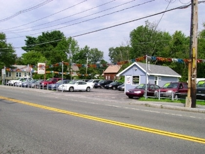
Property Detail
1023 Temple St
WHIT-000021A-000117-000154
Plymouth
Vehiclerentalsvehiclesales
Massachusetts
GB
154
B and X Area of moderate flood hazard, usually the area between the limits of the 100-year and 500-year floods.
0.24 AC
2025
Route 3 South
2025
Boston
521101
Boston-Cambridge-Newton, MA-NH
1,564 SF
NEARBY LISTINGS FOR SALE OR LEASE
DEMOGRAPHICS near 1023 Temple St
1 mile
3 mile
5 mile
2025 Total Population
7,139
91,898
172,751
2030 Population
7,326
91,761
173,223
Pop Growth 2025-2030
+ 2.62%
(0.15%)
+ 0.27%
Average Age
42
39
40
2025 Total Households
2,246
30,919
61,046
HH Growth 2025-2030
+ 2.63%
(0.17%)
+ 0.23%
Median Household Inc
$93,749
$85,185
$93,499
Avg Household Size
2.90
2.80
2.70
2025 Avg HH Vehicles
2.00
2.00
2.00
Median Home Value
$466,186
$463,221
$472,710
Median Year Built
1965
1956
1960
Nearby Places
Map Layers
Map Styles
 Street
 Aerial
Layers
 Traffic
 Biking
Places
Listings with unknown addresses are not visible on the map
- Restaurants
- Banks
- Shops
- Fitness
- Groceries
PUBLIC TRANSPORTATION
COMMUTER RAIL
Brockton (Middleborough/Lakeville Line - Massachusetts Bay Transportation Authority Commuter Rail (Purple Line))
Drive
Walk
Distance
Brockton (Middleborough/Lakeville Line - Massachusetts Bay Transportation Authority Commuter Rail (Purple Line))
5 min
2.5 mi
Whitman (Kingston/Plymouth Line - Massachusetts Bay Transportation Authority Commuter Rail (Purple Line))
Drive
Walk
Distance
Whitman (Kingston/Plymouth Line - Massachusetts Bay Transportation Authority Commuter Rail (Purple Line))
6 min
2.8 mi
AIRPORT
General Edward Lawrence Logan International
Drive
Walk
Distance
General Edward Lawrence Logan International
42 min
26.9 mi
Rhode Island Tf Green International
Drive
Walk
Distance
Rhode Island Tf Green International
73 min
41.9 mi
SALE & LEASE HISTORY
LISTING DATE
SALE/LEASE

Oct 10, 2017
For Sale
Nearby Properties
Address
Land Use
TOTAL SIZE
Lot Size
Zoning
Address
Land Use
TOTAL SIZE
Lot Size
Zoning
3,088 SF
1.42 AC
C3
Address
Land Use
TOTAL SIZE
Lot Size
Zoning
95.27 AC
R1C
Address
Land Use
TOTAL SIZE
Lot Size
Zoning
780 SF
10.81 AC
C5
Address
Land Use
TOTAL SIZE
Lot Size
Zoning
449,704 SF
3.56 AC
C2
Address
Land Use
TOTAL SIZE
Lot Size
Zoning
412,500 SF
48.94 AC
100
Address
Land Use
TOTAL SIZE
Lot Size
Zoning
733 SF
16.41 AC
R1C
Address
Land Use
TOTAL SIZE
Lot Size
Zoning
27,951 SF
1.19 AC
R3
Address
Land Use
TOTAL SIZE
Lot Size
Zoning
36.20 AC
Address
Land Use
TOTAL SIZE
Lot Size
Zoning
920 SF
13.48 AC
R1C
Address
Land Use
TOTAL SIZE
Lot Size
Zoning
3,088 SF
1.38 AC
C3
Address
Land Use
TOTAL SIZE
Lot Size
Zoning
3,438 SF
1.15 AC
C2
Address
Land Use
TOTAL SIZE
Lot Size
Zoning
223,200 SF
5.26 AC
C2
Address
Land Use
TOTAL SIZE
Lot Size
Zoning
88,957 SF
0.57 AC
R2
Address
Land Use
TOTAL SIZE
Lot Size
Zoning
35.10 AC
Address
Land Use
TOTAL SIZE
Lot Size
Zoning
4,074 SF
3.82 AC
R3
Address
Land Use
TOTAL SIZE
Lot Size
Zoning
2,062 SF
5.01 AC
C2
Address
Land Use
TOTAL SIZE
Lot Size
Zoning
130,640 SF
10.27 AC
R1C
Address
Land Use
TOTAL SIZE
Lot Size
Zoning
3,812 SF
0.64 AC
C3
Address
Land Use
TOTAL SIZE
Lot Size
Zoning
299,062 SF
22.73 AC
R2
Address
Land Use
TOTAL SIZE
Lot Size
Zoning
1,172 SF
32.67 AC
R1C
Address
Land Use
TOTAL SIZE
Lot Size
Zoning
3,255 SF
1 AC
C3
Address
Land Use
TOTAL SIZE
Lot Size
Zoning
2,884 SF
3.18 AC
R2
Address
Land Use
TOTAL SIZE
Lot Size
Zoning
1,217 SF
13.79 AC
R1C
Address
Land Use
TOTAL SIZE
Lot Size
Zoning
647 SF
53.67 AC
I3
Address
Land Use
TOTAL SIZE
Lot Size
Zoning
22.54 AC
C2
Address
Land Use
TOTAL SIZE
Lot Size
Zoning
48,997 SF
5.68 AC
R3
Address
Land Use
TOTAL SIZE
Lot Size
Zoning
10.58 AC
R3
Address
Land Use
TOTAL SIZE
Lot Size
Zoning
69,184 SF
7.90 AC
100
Address
Land Use
TOTAL SIZE
Lot Size
Zoning
1,296 SF
10.04 AC
R3
Address
Land Use
TOTAL SIZE
Lot Size
Zoning
207,654 SF
14.17 AC
R1C
The World's #1 Commercial Real Estate Marketplace
Connect with us
© 2026 CoStar Group
The information above has been obtained from sources believed reliable. While we do not doubt its accuracy we have not verified it and make no guarantee, warranty or representation about it. It is your responsibility to independently confirm its accuracy and completeness. Any projections, opinions, assumptions, or estimates used are for example only and do not represent the current or future performance of the property. The value of this transaction to you depends on tax and other factors which should be evaluated by your tax, financial, and legal advisors. You and your advisors should conduct a careful, independent investigation of the property to determine to your satisfaction the suitability of the property for your needs.