Property Record
1023 Us Highway 321 Byp S, Winnsboro, SC 29180
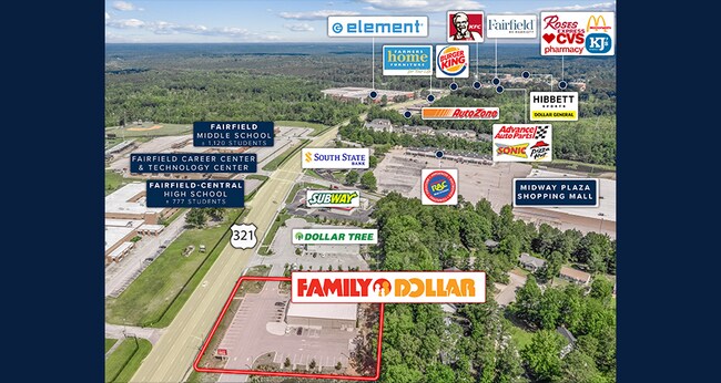

NEARBY LISTINGS FOR SALE OR LEASE
Property Detail
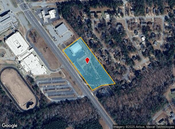
1023 Us Highway 321 Byp S
1450117025000
Survey Prepared For T Invstments Inc
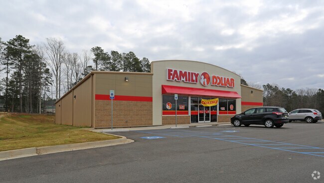
Storebuilding
1023 US 321 BYPASS OV PLAT: 605 - 611, B - 335 THE FAMILY DOLLAR STORE
X
Fairfield
45039C0351C
South Carolina
2025
1.55 AC
2024
Fairfield County
960401
Columbia
8,320 SF
Columbia, SC
DEMOGRAPHICS near 1023 Us Highway 321 Byp S
1 Mile
3 Mile
5 Mile
2024 Total Population
2,120
6,481
8,069
2029 Population
2,055
6,299
7,834
Pop Growth 2024-2029
(3.07%)
(2.81%)
(2.91%)
Average Age
40
42
43
2024 Total Households
900
2,864
3,540
HH Growth 2024-2029
(2.78%)
(2.55%)
(2.68%)
Median Household Inc
$32,951
$33,129
$34,767
Avg Household Size
2.30
2.20
2.20
2024 Avg HH Vehicles
1.00
2.00
2.00
Median Home Value
$84,745
$93,675
$98,480
Median Year Built
1973
1978
1980
Nearby Places
- Restaurants
- Banks
- Shops
- Fitness
- Groceries
PUBLIC TRANSPORTATION
AIRPORT
Columbia Metro
DRIVE
WALK
Distance
Columbia Metro
59 min
42.1 mi
Freight Ports
North Charleston Terminal
DRIVE
WALK
Distance
North Charleston Terminal
158 min
139.2 mi
SALE & LEASE HISTORY
LISTING DATE
SALE/LEASE

Sep 18, 2023
For Sale
Nov 26, 2018
For Sale
May 23, 2018
For Sale
Mar 26, 2019
For Sale
Jul 26, 2018
For Sale
Jul 22, 2020
For Sale
Jan 08, 2019
For Sale
Jan 06, 2023
For Sale
Feb 05, 2019
For Sale
Aug 23, 2018
For Sale
Nearby Properties
Address
Land Use
TOTAL SIZE
Lot Size
Zoning
Address
Land Use
TOTAL SIZE
Lot Size
Zoning
307,847 SF
38.43 AC
I-1
Address
Land Use
TOTAL SIZE
Lot Size
Zoning
12,664 SF
3 AC
B2
Address
Land Use
TOTAL SIZE
Lot Size
Zoning
6,480 SF
1.61 AC
B2
Address
Land Use
TOTAL SIZE
Lot Size
Zoning
225 AC
I-1
Address
Land Use
TOTAL SIZE
Lot Size
Zoning
9,969 SF
1 AC
R3
Address
Land Use
TOTAL SIZE
Lot Size
Zoning
26,146 SF
162.02 AC
APD
Address
Land Use
TOTAL SIZE
Lot Size
Zoning
150.48 AC
I-1
Address
Land Use
TOTAL SIZE
Lot Size
Zoning
11,335 SF
1.02 AC
C1
Address
Land Use
TOTAL SIZE
Lot Size
Zoning
9,382 SF
4.48 AC
R3
Address
Land Use
TOTAL SIZE
Lot Size
Zoning
7,944 SF
8.50 AC
R1
Address
Land Use
TOTAL SIZE
Lot Size
Zoning
1,951 SF
2 AC
C1
Address
Land Use
TOTAL SIZE
Lot Size
Zoning
109.69 AC
RD-1
Address
Land Use
TOTAL SIZE
Lot Size
Zoning
6,000 SF
1.04 AC
B2
Address
Land Use
TOTAL SIZE
Lot Size
Zoning
4,802 SF
2.71 AC
R2
Address
Land Use
TOTAL SIZE
Lot Size
Zoning
6,643 SF
1.77 AC
I1
Address
Land Use
TOTAL SIZE
Lot Size
Zoning
14,984 SF
0.55 AC
C1
Address
Land Use
TOTAL SIZE
Lot Size
Zoning
6,000 SF
1.14 AC
C1
Address
Land Use
TOTAL SIZE
Lot Size
Zoning
3,200 SF
5.50 AC
B2
Address
Land Use
TOTAL SIZE
Lot Size
Zoning
48.92 AC
R1
Address
Land Use
TOTAL SIZE
Lot Size
Zoning
3,867 SF
0.47 AC
C1
Address
Land Use
TOTAL SIZE
Lot Size
Zoning
1,041 SF
0.28 AC
C1
Address
Land Use
TOTAL SIZE
Lot Size
Zoning
4,756 SF
8.16 AC
C1
Address
Land Use
TOTAL SIZE
Lot Size
Zoning
9.21 AC
I-1
Address
Land Use
TOTAL SIZE
Lot Size
Zoning
3,200 SF
1.18 AC
R1
Address
Land Use
TOTAL SIZE
Lot Size
Zoning
1,551 SF
1.50 AC
B2
Address
Land Use
TOTAL SIZE
Lot Size
Zoning
3,200 SF
0.04 AC
R1
Address
Land Use
TOTAL SIZE
Lot Size
Zoning
6,654 SF
0.46 AC
C1
Address
Land Use
TOTAL SIZE
Lot Size
Zoning
41,321 SF
8.01 AC
B2
Address
Land Use
TOTAL SIZE
Lot Size
Zoning
2,372 SF
0.69 AC
C2
The World's #1 Commercial Real Estate Marketplace
Connect with us
© 2025 CoStar Group
The information above has been obtained from sources believed reliable. While we do not doubt its accuracy we have not verified it and make no guarantee, warranty or representation about it. It is your responsibility to independently confirm its accuracy and completeness. Any projections, opinions, assumptions, or estimates used are for example only and do not represent the current or future performance of the property. The value of this transaction to you depends on tax and other factors which should be evaluated by your tax, financial, and legal advisors. You and your advisors should conduct a careful, independent investigation of the property to determine to your satisfaction the suitability of the property for your needs.