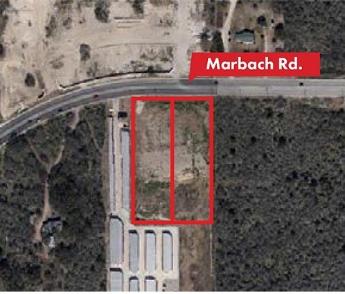
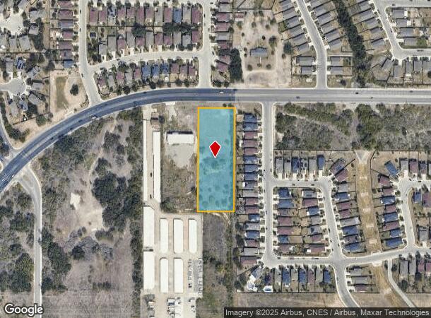
Property Record
10232 Marbach Rd, San Antonio, TX 78245
NEARBY LISTINGS FOR SALE OR LEASE
-
-
-
-
-
-
-
-
-
-
-
-
-
-
-
-
-
-
-
-
-
-
-
-
State Highway 151 & Military Drive W
San Antonio, TX 78251
Rent Upon Request
1.18 - 2.88 AC Lot
Land
-
-
-
-
-
-
View all San Antonio listings for sale on LoopNet.com
Property Detail
10232 Marbach Rd
San Antonio-New Braunfels, TX
Aaa Storage Marbach Subd
05197-530-0010
CB 5197E BLK 30 LOT 1 (AAA STORAGE MARBACH SUBD)
Vacantlandnec
Bexar
X
Texas
48029C0365F
1
2024
2.01 AC
2025
Far West
171922
San Antonio
27,677 SF
DEMOGRAPHICS near 10232 Marbach Rd
1 Mile
3 Mile
5 Mile
2024 Total Population
18,209
124,010
243,994
2029 Population
19,299
132,171
261,495
Pop Growth 2024-2029
+ 5.99%
+ 6.58%
+ 7.17%
Average Age
34
34
34
2024 Total Households
5,669
40,629
80,692
HH Growth 2024-2029
+ 6.14%
+ 6.76%
+ 7.30%
Median Household Inc
$85,622
$73,901
$72,227
Avg Household Size
3.20
3.00
2.90
2024 Avg HH Vehicles
2.00
2.00
2.00
Median Home Value
$199,949
$201,241
$209,670
Median Year Built
2003
2003
2002
Nearby Places
Map Layers
Map Styles
 Street
 Aerial
- Restaurants
- Banks
- Shops
- Fitness
- Groceries
PUBLIC TRANSPORTATION
AIRPORT
San Antonio International
DRIVE
WALK
Distance
San Antonio International
24 min
17.0 mi
Freight Ports
Port of Corpus Christi
DRIVE
WALK
Distance
Port of Corpus Christi
163 min
156.6 mi
SALE & LEASE HISTORY
LISTING DATE
SALE/LEASE

Sep 24, 2016
For Sale
Jul 17, 2017
For Sale
Nearby Properties
Address
Land Use
TOTAL SIZE
Lot Size
Zoning
Address
Land Use
TOTAL SIZE
Lot Size
Zoning
236,594 SF
25.35 AC
Address
Land Use
TOTAL SIZE
Lot Size
Zoning
304,232 SF
99.80 AC
Address
Land Use
TOTAL SIZE
Lot Size
Zoning
341,212 SF
15 AC
Address
Land Use
TOTAL SIZE
Lot Size
Zoning
331,109 SF
14.44 AC
Address
Land Use
TOTAL SIZE
Lot Size
Zoning
369,951 SF
21.42 AC
Address
Land Use
TOTAL SIZE
Lot Size
Zoning
361,708 SF
17.83 AC
Address
Land Use
TOTAL SIZE
Lot Size
Zoning
532,921 SF
21.80 AC
Address
Land Use
TOTAL SIZE
Lot Size
Zoning
50,135 SF
10.96 AC
Address
Land Use
TOTAL SIZE
Lot Size
Zoning
368,012 SF
22.27 AC
Address
Land Use
TOTAL SIZE
Lot Size
Zoning
336,383 SF
18.71 AC
Address
Land Use
TOTAL SIZE
Lot Size
Zoning
286,006 SF
13.43 AC
Address
Land Use
TOTAL SIZE
Lot Size
Zoning
375,203 SF
15.99 AC
Address
Land Use
TOTAL SIZE
Lot Size
Zoning
202,122 SF
20.56 AC
Address
Land Use
TOTAL SIZE
Lot Size
Zoning
360,108 SF
24 AC
Address
Land Use
TOTAL SIZE
Lot Size
Zoning
337,360 SF
13.33 AC
Address
Land Use
TOTAL SIZE
Lot Size
Zoning
328,060 SF
16.19 AC
Address
Land Use
TOTAL SIZE
Lot Size
Zoning
241,445 SF
15.86 AC
Address
Land Use
TOTAL SIZE
Lot Size
Zoning
324,175 SF
39.17 AC
Address
Land Use
TOTAL SIZE
Lot Size
Zoning
577,717 SF
418.25 AC
Address
Land Use
TOTAL SIZE
Lot Size
Zoning
209,657 SF
26.97 AC
Address
Land Use
TOTAL SIZE
Lot Size
Zoning
263,255 SF
14.59 AC
Address
Land Use
TOTAL SIZE
Lot Size
Zoning
263,976 SF
17.42 AC
Address
Land Use
TOTAL SIZE
Lot Size
Zoning
209,459 SF
18.25 AC
Address
Land Use
TOTAL SIZE
Lot Size
Zoning
319,143 SF
30.15 AC
Address
Land Use
TOTAL SIZE
Lot Size
Zoning
228,494 SF
12.74 AC
Address
Land Use
TOTAL SIZE
Lot Size
Zoning
266,680 SF
30.19 AC
Address
Land Use
TOTAL SIZE
Lot Size
Zoning
269,610 SF
15.64 AC
Address
Land Use
TOTAL SIZE
Lot Size
Zoning
253,856 SF
5.84 AC
Address
Land Use
TOTAL SIZE
Lot Size
Zoning
267,972 SF
13.26 AC
Address
Land Use
TOTAL SIZE
Lot Size
Zoning
199,954 SF
10.29 AC
The World's #1 Commercial Real Estate Marketplace
Connect with us
© 2025 CoStar Group
The information above has been obtained from sources believed reliable. While we do not doubt its accuracy we have not verified it and make no guarantee, warranty or representation about it. It is your responsibility to independently confirm its accuracy and completeness. Any projections, opinions, assumptions, or estimates used are for example only and do not represent the current or future performance of the property. The value of this transaction to you depends on tax and other factors which should be evaluated by your tax, financial, and legal advisors. You and your advisors should conduct a careful, independent investigation of the property to determine to your satisfaction the suitability of the property for your needs.