Property Record
10235 Highway 22, Ponchatoula, LA 70454

NEARBY LISTINGS FOR SALE OR LEASE
-
-
View all Ponchatoula listings for sale on LoopNet.com
Property Detail
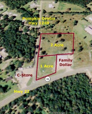
10235 Highway 22
05980453
1.00A LOCATED IN THE NORTH EAST CORNER OF HWY 22 & PUMPKIN CENTER RD IN SEC 54 T7SR7E B800 P615 B1169 P747 B1312 P707 MAP 800
Commercialnec
Tangipahoa
X
Louisiana
22063C0300E
1.42 AC
2024
Louisiana South Area
2024
Other Market Areas
954105
Hammond, LA
5,856 SF
DEMOGRAPHICS near 10235 Highway 22
1 Mile
3 Mile
5 Mile
2024 Total Population
1,437
10,529
28,174
2029 Population
1,558
11,397
30,615
Pop Growth 2024-2029
+ 8.42%
+ 8.24%
+ 8.66%
Average Age
42
41
40
2024 Total Households
585
4,170
11,020
HH Growth 2024-2029
+ 8.55%
+ 8.30%
+ 8.67%
Median Household Inc
$66,209
$66,781
$58,772
Avg Household Size
2.40
2.50
2.50
2024 Avg HH Vehicles
2.00
2.00
2.00
Median Home Value
$225,454
$258,449
$213,385
Median Year Built
1994
1997
1997
Nearby Places
Map Layers
Map Styles
 Street
 Aerial
- Restaurants
- Banks
- Shops
- Fitness
- Groceries
Nearby Properties
Address
Land Use
TOTAL SIZE
Lot Size
Zoning
Address
Land Use
TOTAL SIZE
Lot Size
Zoning
11,595 SF
25.66 AC
Address
Land Use
TOTAL SIZE
Lot Size
Zoning
25,312 SF
3.68 AC
Address
Land Use
TOTAL SIZE
Lot Size
Zoning
25,000 SF
4.63 AC
Address
Land Use
TOTAL SIZE
Lot Size
Zoning
148.71 AC
Address
Land Use
TOTAL SIZE
Lot Size
Zoning
38,780 SF
8.55 AC
Address
Land Use
TOTAL SIZE
Lot Size
Zoning
27,096 SF
5.50 AC
Address
Land Use
TOTAL SIZE
Lot Size
Zoning
88.01 AC
Address
Land Use
TOTAL SIZE
Lot Size
Zoning
4,200 SF
0.64 AC
Address
Land Use
TOTAL SIZE
Lot Size
Zoning
Address
Land Use
TOTAL SIZE
Lot Size
Zoning
15,586 SF
5.01 AC
Address
Land Use
TOTAL SIZE
Lot Size
Zoning
10,640 SF
2 AC
Address
Land Use
TOTAL SIZE
Lot Size
Zoning
Address
Land Use
TOTAL SIZE
Lot Size
Zoning
70,040 SF
13.10 AC
Address
Land Use
TOTAL SIZE
Lot Size
Zoning
3.03 AC
Address
Land Use
TOTAL SIZE
Lot Size
Zoning
11,520 SF
2.75 AC
Address
Land Use
TOTAL SIZE
Lot Size
Zoning
6,918 SF
2.58 AC
Address
Land Use
TOTAL SIZE
Lot Size
Zoning
Address
Land Use
TOTAL SIZE
Lot Size
Zoning
Address
Land Use
TOTAL SIZE
Lot Size
Zoning
Address
Land Use
TOTAL SIZE
Lot Size
Zoning
Address
Land Use
TOTAL SIZE
Lot Size
Zoning
9,270 SF
0.66 AC
Address
Land Use
TOTAL SIZE
Lot Size
Zoning
Address
Land Use
TOTAL SIZE
Lot Size
Zoning
0.64 AC
Address
Land Use
TOTAL SIZE
Lot Size
Zoning
10,760 SF
1.16 AC
Address
Land Use
TOTAL SIZE
Lot Size
Zoning
Address
Land Use
TOTAL SIZE
Lot Size
Zoning
Address
Land Use
TOTAL SIZE
Lot Size
Zoning
Address
Land Use
TOTAL SIZE
Lot Size
Zoning
Address
Land Use
TOTAL SIZE
Lot Size
Zoning
3.32 AC
The World's #1 Commercial Real Estate Marketplace
Connect with us
© 2025 CoStar Group
The information above has been obtained from sources believed reliable. While we do not doubt its accuracy we have not verified it and make no guarantee, warranty or representation about it. It is your responsibility to independently confirm its accuracy and completeness. Any projections, opinions, assumptions, or estimates used are for example only and do not represent the current or future performance of the property. The value of this transaction to you depends on tax and other factors which should be evaluated by your tax, financial, and legal advisors. You and your advisors should conduct a careful, independent investigation of the property to determine to your satisfaction the suitability of the property for your needs.