Property Record
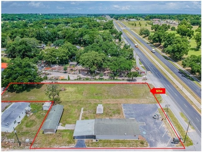
10235 Us Highway 301, Dade City, FL 33525


NEARBY LISTINGS FOR SALE OR LEASE
Property Detail
10235 Us Highway 301
15-25-21-0000-02800-0000
U.S. 301
Storebuilding
BEG AT INTSC OF S LINE OF NE 1/4 OF SE1/4 WITH W R/W US 301 FOR A POB TH W 200 FT TH N 100 FT TH E 200 FT TH S 100 FT TO POB & THE W 313 FT OF E 365.31 FT OF S 83.82 FT OF N 106.82 FT OF S 206.82 FT OF NE 1/4 OF SE 1/4
X
Pasco
12101C0287F
Florida
2024
1.06 AC
2026
Pasco County
032805
Tampa/St Petersburg
2,700 SF
Tampa-St. Petersburg-Clearwater, FL
DEMOGRAPHICS near 10235 Us Highway 301
1 Mile
3 Mile
5 Mile
2024 Total Population
1,061
15,040
56,904
2029 Population
1,262
18,241
68,984
Pop Growth 2024-2029
+ 18.94%
+ 21.28%
+ 21.23%
Average Age
50
47
45
2024 Total Households
469
6,359
23,611
HH Growth 2024-2029
+ 18.98%
+ 21.18%
+ 21.41%
Median Household Inc
$57,983
$53,545
$51,359
Avg Household Size
2.30
2.30
2.30
2024 Avg HH Vehicles
2.00
2.00
2.00
Median Home Value
$186,363
$174,122
$169,798
Median Year Built
1989
1992
1986
Nearby Places
Map Layers
Map Styles
 Street
 Aerial
- Restaurants
- Banks
- Shops
- Fitness
- Groceries
PUBLIC TRANSPORTATION
AIRPORT
Tampa International
DRIVE
WALK
Distance
Tampa International
61 min
40.5 mi
Freight Ports
Port of Tampa Bay
DRIVE
WALK
Distance
Port of Tampa Bay
54 min
34.7 mi
SALE & LEASE HISTORY
LISTING DATE
SALE/LEASE

May 15, 2019
For Sale
Nearby Properties
Address
Land Use
TOTAL SIZE
Lot Size
Zoning
Address
Land Use
TOTAL SIZE
Lot Size
Zoning
273,092 SF
12.29 AC
R4
Address
Land Use
TOTAL SIZE
Lot Size
Zoning
127,340 SF
15.04 AC
AC
Address
Land Use
TOTAL SIZE
Lot Size
Zoning
107,232 SF
12.79 AC
MPUD
Address
Land Use
TOTAL SIZE
Lot Size
Zoning
88,782 SF
4.09 AC
M1
Address
Land Use
TOTAL SIZE
Lot Size
Zoning
98,980 SF
5.36 AC
C2
Address
Land Use
TOTAL SIZE
Lot Size
Zoning
216,202 SF
23.77 AC
C2
Address
Land Use
TOTAL SIZE
Lot Size
Zoning
79,605 SF
3.13 AC
C2
Address
Land Use
TOTAL SIZE
Lot Size
Zoning
80,036 SF
12 AC
C2
Address
Land Use
TOTAL SIZE
Lot Size
Zoning
98,666 SF
19.80 AC
RIO
Address
Land Use
TOTAL SIZE
Lot Size
Zoning
105,449 SF
5.14 AC
OP
Address
Land Use
TOTAL SIZE
Lot Size
Zoning
56,312 SF
8.85 AC
PUD
Address
Land Use
TOTAL SIZE
Lot Size
Zoning
54,371 SF
8.09 AC
CH
Address
Land Use
TOTAL SIZE
Lot Size
Zoning
16,994 SF
2.40 AC
CG
Address
Land Use
TOTAL SIZE
Lot Size
Zoning
111,677 SF
10.40 AC
CG
Address
Land Use
TOTAL SIZE
Lot Size
Zoning
62,320 SF
8.13 AC
R4
Address
Land Use
TOTAL SIZE
Lot Size
Zoning
123,959 SF
15.18 AC
C2
Address
Land Use
TOTAL SIZE
Lot Size
Zoning
86,138 SF
6.62 AC
CG
Address
Land Use
TOTAL SIZE
Lot Size
Zoning
67,222 SF
7.96 AC
C2
Address
Land Use
TOTAL SIZE
Lot Size
Zoning
37,368 SF
10.82 AC
CG
Address
Land Use
TOTAL SIZE
Lot Size
Zoning
76,818 SF
15 AC
AC
Address
Land Use
TOTAL SIZE
Lot Size
Zoning
89,820 SF
6.96 AC
C2
Address
Land Use
TOTAL SIZE
Lot Size
Zoning
26,520 SF
4.42 AC
CG
Address
Land Use
TOTAL SIZE
Lot Size
Zoning
142.77 AC
MPUD
Address
Land Use
TOTAL SIZE
Lot Size
Zoning
95,673 SF
7.51 AC
PDH2
Address
Land Use
TOTAL SIZE
Lot Size
Zoning
106,978 SF
14.78 AC
C2
Address
Land Use
TOTAL SIZE
Lot Size
Zoning
47,244 SF
4.50 AC
R4
Address
Land Use
TOTAL SIZE
Lot Size
Zoning
112,952 SF
13.03 AC
MF1
Address
Land Use
TOTAL SIZE
Lot Size
Zoning
16,261 SF
4.35 AC
C2
Address
Land Use
TOTAL SIZE
Lot Size
Zoning
28,109 SF
9.37 AC
AR1
Address
Land Use
TOTAL SIZE
Lot Size
Zoning
54,400 SF
3.03 AC
CG
The World's #1 Commercial Real Estate Marketplace
Connect with us
© 2026 CoStar Group
The information above has been obtained from sources believed reliable. While we do not doubt its accuracy we have not verified it and make no guarantee, warranty or representation about it. It is your responsibility to independently confirm its accuracy and completeness. Any projections, opinions, assumptions, or estimates used are for example only and do not represent the current or future performance of the property. The value of this transaction to you depends on tax and other factors which should be evaluated by your tax, financial, and legal advisors. You and your advisors should conduct a careful, independent investigation of the property to determine to your satisfaction the suitability of the property for your needs.