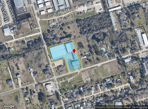
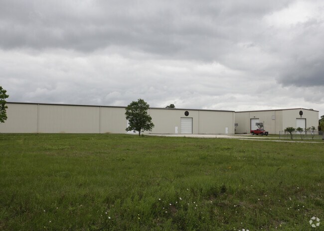
Property Record
1024 Delesandri Ln, Kemah, TX 77565

NEARBY LISTINGS FOR SALE OR LEASE
Property Detail
1024 Delesandri Ln
Houston-The Woodlands-Sugar Land, TX
Jarboe
4235-0006-0007-003
ABST 18 M MULDOON SUR PRTL RPLT OF LOT 7 (7-3) BLK 6 JARBOE ADDN 2.8087 ACRES AKA RES A BLK 1 REPLAT
Commercialnec
Galveston
X
Texas
48167C0044G
7
2024
2.81 AC
2025
East-Southeast Far
721208
Houston
55,900 SF
DEMOGRAPHICS near 1024 Delesandri Ln
1 Mile
3 Mile
5 Mile
2024 Total Population
6,943
59,988
128,569
2029 Population
7,204
62,446
133,333
Pop Growth 2024-2029
+ 3.76%
+ 4.10%
+ 3.71%
Average Age
37
39
38
2024 Total Households
2,699
23,613
50,392
HH Growth 2024-2029
+ 4.15%
+ 4.29%
+ 3.78%
Median Household Inc
$112,906
$109,967
$91,209
Avg Household Size
2.50
2.50
2.50
2024 Avg HH Vehicles
2.00
2.00
2.00
Median Home Value
$272,404
$313,609
$286,185
Median Year Built
1995
1995
1991
Nearby Places
Map Layers
Map Styles
 Street
 Aerial
- Restaurants
- Banks
- Shops
- Fitness
- Groceries
PUBLIC TRANSPORTATION
AIRPORT
William P Hobby
DRIVE
WALK
Distance
William P Hobby
36 min
20.6 mi
George Bush Intcntl/Houston
DRIVE
WALK
Distance
George Bush Intcntl/Houston
60 min
46.6 mi
Freight Ports
Port of Galveston
DRIVE
WALK
Distance
Port of Galveston
34 min
25.4 mi
Nearby Properties
Address
Land Use
TOTAL SIZE
Lot Size
Zoning
Address
Land Use
TOTAL SIZE
Lot Size
Zoning
500,000 SF
125.06 AC
Address
Land Use
TOTAL SIZE
Lot Size
Zoning
502,791 SF
123.05 AC
Address
Land Use
TOTAL SIZE
Lot Size
Zoning
320,892 SF
15 AC
Address
Land Use
TOTAL SIZE
Lot Size
Zoning
372,183 SF
11.16 AC
Address
Land Use
TOTAL SIZE
Lot Size
Zoning
372,456 SF
20.15 AC
Address
Land Use
TOTAL SIZE
Lot Size
Zoning
415,941 SF
14.35 AC
Address
Land Use
TOTAL SIZE
Lot Size
Zoning
260,988 SF
11.78 AC
Address
Land Use
TOTAL SIZE
Lot Size
Zoning
282,246 SF
19.56 AC
Address
Land Use
TOTAL SIZE
Lot Size
Zoning
370,220 SF
28.57 AC
Address
Land Use
TOTAL SIZE
Lot Size
Zoning
428,859 SF
23.20 AC
Address
Land Use
TOTAL SIZE
Lot Size
Zoning
319,572 SF
9.54 AC
Address
Land Use
TOTAL SIZE
Lot Size
Zoning
281,944 SF
20.68 AC
Address
Land Use
TOTAL SIZE
Lot Size
Zoning
321,584 SF
15.45 AC
Address
Land Use
TOTAL SIZE
Lot Size
Zoning
157,001 SF
22 AC
Address
Land Use
TOTAL SIZE
Lot Size
Zoning
274,612 SF
11.94 AC
Address
Land Use
TOTAL SIZE
Lot Size
Zoning
211,805 SF
6.77 AC
Address
Land Use
TOTAL SIZE
Lot Size
Zoning
196,951 SF
10.90 AC
Address
Land Use
TOTAL SIZE
Lot Size
Zoning
269,687 SF
14.64 AC
Address
Land Use
TOTAL SIZE
Lot Size
Zoning
253,306 SF
12.33 AC
Address
Land Use
TOTAL SIZE
Lot Size
Zoning
181,500 SF
47.24 AC
Address
Land Use
TOTAL SIZE
Lot Size
Zoning
188,850 SF
9.28 AC
Address
Land Use
TOTAL SIZE
Lot Size
Zoning
207,624 SF
10.66 AC
Address
Land Use
TOTAL SIZE
Lot Size
Zoning
148,017 SF
18.86 AC
Address
Land Use
TOTAL SIZE
Lot Size
Zoning
222,005 SF
14.55 AC
Address
Land Use
TOTAL SIZE
Lot Size
Zoning
210,641 SF
7.59 AC
Address
Land Use
TOTAL SIZE
Lot Size
Zoning
265,290 SF
10.07 AC
Address
Land Use
TOTAL SIZE
Lot Size
Zoning
256,771 SF
3.86 AC
Address
Land Use
TOTAL SIZE
Lot Size
Zoning
197,268 SF
3.43 AC
Address
Land Use
TOTAL SIZE
Lot Size
Zoning
193,468 SF
12.03 AC
Address
Land Use
TOTAL SIZE
Lot Size
Zoning
115,444 SF
8.42 AC
The World's #1 Commercial Real Estate Marketplace
Connect with us
© 2025 CoStar Group
The information above has been obtained from sources believed reliable. While we do not doubt its accuracy we have not verified it and make no guarantee, warranty or representation about it. It is your responsibility to independently confirm its accuracy and completeness. Any projections, opinions, assumptions, or estimates used are for example only and do not represent the current or future performance of the property. The value of this transaction to you depends on tax and other factors which should be evaluated by your tax, financial, and legal advisors. You and your advisors should conduct a careful, independent investigation of the property to determine to your satisfaction the suitability of the property for your needs.