Property Record
1024 Highpoint Rd, Summit, MS 39666
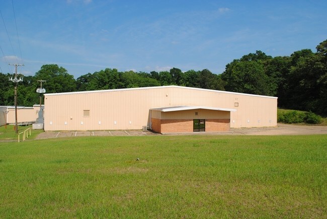


This Property Is For Sale
Property Detail
1024 Highpoint Rd
600602-A
SE1/4 SE1/4 OF OLD HWY 51 & W OF ICGRR ZN:X-28113C0037C
Warehouse
Pike
I1
Mississippi
B and X Area of moderate flood hazard, usually the area between the limits of the 100-year and 500-year floods.
13.50 AC
2025
Hattiesburg/South Area
2025
Other Market Areas
950200
McComb, MS
66,584 SF
NEARBY LISTINGS FOR SALE OR LEASE
-
-
View all Summit listings for sale on LoopNet.com
DEMOGRAPHICS near 1024 Highpoint Rd
1 mile
3 mile
5 mile
2025 Total Population
1,797
8,564
20,698
2030 Population
1,734
8,342
20,138
Pop Growth 2025-2030
(3.51%)
(2.59%)
(2.71%)
Average Age
38
39
39
2025 Total Households
645
3,362
8,230
HH Growth 2025-2030
(3.41%)
(2.59%)
(2.70%)
Median Household Inc
$42,647
$39,285
$43,543
Avg Household Size
2.30
2.30
2.40
2025 Avg HH Vehicles
2.00
2.00
2.00
Median Home Value
$147,200
$133,042
$136,925
Median Year Built
1979
1979
1980
Nearby Places
Map Layers
Map Styles
 Street
 Aerial
Layers
 Traffic
 Biking
Places
Listings with unknown addresses are not visible on the map
- Restaurants
- Banks
- Shops
- Fitness
- Groceries
PUBLIC TRANSPORTATION
COMMUTER RAIL
Mccomb (City of New Orleans - Amtrak)
Drive
Walk
Distance
Mccomb (City of New Orleans - Amtrak)
7 min
4.4 mi
Freight Ports
Port of Greater Baton Rouge
Drive
Walk
Distance
Port of Greater Baton Rouge
118 min
103.4 mi
Nearby Properties
Address
Land Use
TOTAL SIZE
Lot Size
Zoning
Address
Land Use
TOTAL SIZE
Lot Size
Zoning
220,645 SF
20.43 AC
CPL
Address
Land Use
TOTAL SIZE
Lot Size
Zoning
7,790 SF
1.23 AC
RPL
Address
Land Use
TOTAL SIZE
Lot Size
Zoning
117,268 SF
14.16 AC
CPL
Address
Land Use
TOTAL SIZE
Lot Size
Zoning
49,490 SF
2.36 AC
C2
Address
Land Use
TOTAL SIZE
Lot Size
Zoning
31,976 SF
3.96 AC
BPO
Address
Land Use
TOTAL SIZE
Lot Size
Zoning
25,114 SF
4.14 AC
C1
Address
Land Use
TOTAL SIZE
Lot Size
Zoning
48,107 SF
3.80 AC
C1
Address
Land Use
TOTAL SIZE
Lot Size
Zoning
73,961 SF
1.94 AC
CPL
Address
Land Use
TOTAL SIZE
Lot Size
Zoning
187,912 SF
1 AC
CPL
Address
Land Use
TOTAL SIZE
Lot Size
Zoning
32,565 SF
1.49 AC
Address
Land Use
TOTAL SIZE
Lot Size
Zoning
43,457 SF
7.22 AC
RPL
Address
Land Use
TOTAL SIZE
Lot Size
Zoning
35,177 SF
1.36 AC
C2
Address
Land Use
TOTAL SIZE
Lot Size
Zoning
7,577 SF
0.96 AC
C2
Address
Land Use
TOTAL SIZE
Lot Size
Zoning
12,092 SF
12.24 AC
Address
Land Use
TOTAL SIZE
Lot Size
Zoning
50,507 SF
3.97 AC
SOM
Address
Land Use
TOTAL SIZE
Lot Size
Zoning
97,627 SF
1 AC
CPL
Address
Land Use
TOTAL SIZE
Lot Size
Zoning
30,090 SF
7.39 AC
CPL
Address
Land Use
TOTAL SIZE
Lot Size
Zoning
14,246 SF
2.56 AC
CPL
Address
Land Use
TOTAL SIZE
Lot Size
Zoning
4,397 SF
10 AC
RPL
Address
Land Use
TOTAL SIZE
Lot Size
Zoning
2,659 SF
6.43 AC
R80
Address
Land Use
TOTAL SIZE
Lot Size
Zoning
3,789 SF
2.47 AC
SOM
Address
Land Use
TOTAL SIZE
Lot Size
Zoning
11,286 SF
2.17 AC
RPL
Address
Land Use
TOTAL SIZE
Lot Size
Zoning
21,681 SF
2.90 AC
RPL
Address
Land Use
TOTAL SIZE
Lot Size
Zoning
22,327 SF
1.67 AC
R60
Address
Land Use
TOTAL SIZE
Lot Size
Zoning
5,146 SF
1.38 AC
Address
Land Use
TOTAL SIZE
Lot Size
Zoning
6,130 SF
4.10 AC
RPL
Address
Land Use
TOTAL SIZE
Lot Size
Zoning
14,521 SF
1.30 AC
CPL
Address
Land Use
TOTAL SIZE
Lot Size
Zoning
8,312 SF
3.43 AC
SOM
Address
Land Use
TOTAL SIZE
Lot Size
Zoning
3,062 SF
0.34 AC
C1
Address
Land Use
TOTAL SIZE
Lot Size
Zoning
66,584 SF
13.50 AC
I1
The World's #1 Commercial Real Estate Marketplace
Connect with us
© 2026 CoStar Group
The information above has been obtained from sources believed reliable. While we do not doubt its accuracy we have not verified it and make no guarantee, warranty or representation about it. It is your responsibility to independently confirm its accuracy and completeness. Any projections, opinions, assumptions, or estimates used are for example only and do not represent the current or future performance of the property. The value of this transaction to you depends on tax and other factors which should be evaluated by your tax, financial, and legal advisors. You and your advisors should conduct a careful, independent investigation of the property to determine to your satisfaction the suitability of the property for your needs.