Property Record
1024 Insignia Loop, Bremerton, WA 98310
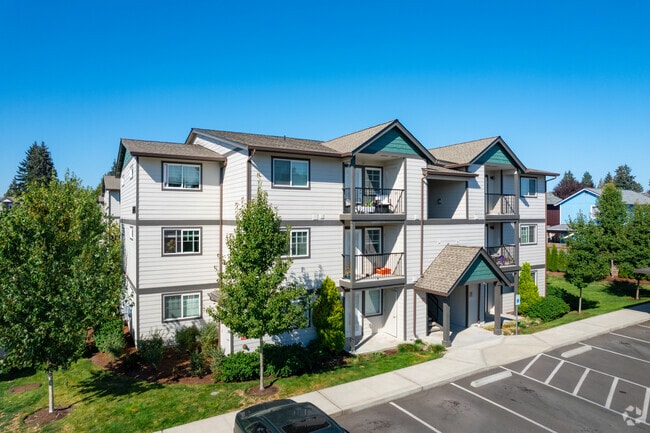

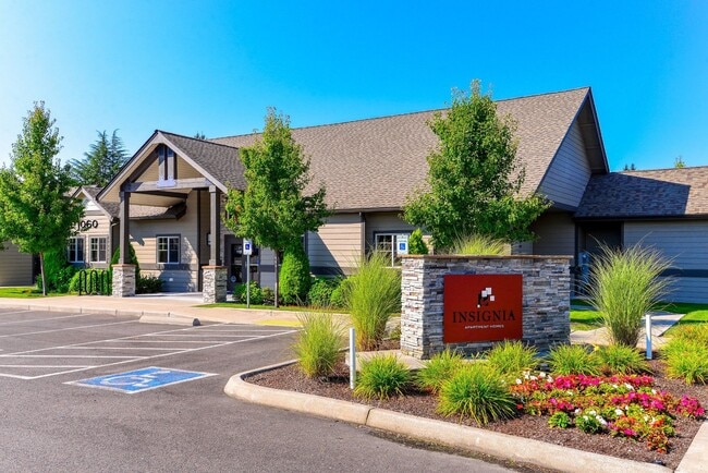
Property Detail
1024 Insignia Loop
022401-1-103-2009
RESULTANT PARCEL OF DECLARATION OF AGGREGATION RECORDED UNDER AUDITORS FILE NO. 201610280172, BEING DESCRIBED AS FOLLOWS: RESULTANT PARCELS B, C AND D OF BOUNDARY LINE ADJUSTMENT RECORDED UNDER AUDITORS FILE NO. 201603300214, RECORDS OF KITSAP COUNTY
Multifamilydwelling
KITSAP
GC
Washington
B and X Area of moderate flood hazard, usually the area between the limits of the 100-year and 500-year floods.
a
2025
6.85 AC
2026
East Bremerton
080102
Bremerton/Silverdale
134,724 SF
Bremerton-Silverdale-Port Orchard, WA
NEARBY LISTINGS FOR SALE OR LEASE
DEMOGRAPHICS near 1024 Insignia Loop
1 mile
3 mile
5 mile
2025 Total Population
12,991
70,325
118,975
2030 Population
13,401
71,909
121,816
Pop Growth 2025-2030
+ 3.16%
+ 2.25%
+ 2.39%
Average Age
40
40
40
2025 Total Households
5,256
26,775
46,132
HH Growth 2025-2030
+ 3.31%
+ 2.54%
+ 2.62%
Median Household Inc
$74,826
$83,819
$88,039
Avg Household Size
2.40
2.40
2.40
2025 Avg HH Vehicles
2.00
2.00
2.00
Median Home Value
$430,902
$460,371
$485,366
Median Year Built
1978
1975
1980
Nearby Places
Map Layers
Map Styles
 Street
 Aerial
Layers
 Traffic
 Biking
Places
Listings with unknown addresses are not visible on the map
- Restaurants
- Banks
- Shops
- Fitness
- Groceries
PUBLIC TRANSPORTATION
AIRPORT
Seattle Paine Field International
Drive
Walk
Distance
Seattle Paine Field International
88 min
40.1 mi
Freight Ports
Port of Seattle
Drive
Walk
Distance
Port of Seattle
93 min
67.4 mi
Nearby Properties
Address
Land Use
TOTAL SIZE
Lot Size
Zoning
Address
Land Use
TOTAL SIZE
Lot Size
Zoning
329,553 SF
18.89 AC
UM
Address
Land Use
TOTAL SIZE
Lot Size
Zoning
0.13 AC
UH
Address
Land Use
TOTAL SIZE
Lot Size
Zoning
107,223 SF
12.76 AC
UM
Address
Land Use
TOTAL SIZE
Lot Size
Zoning
151,599 SF
5.44 AC
R-40
Address
Land Use
TOTAL SIZE
Lot Size
Zoning
132,092 SF
16.36 AC
UM
Address
Land Use
TOTAL SIZE
Lot Size
Zoning
2,672 SF
0.13 AC
UHUL
Address
Land Use
TOTAL SIZE
Lot Size
Zoning
214,450 SF
21.68 AC
R-40
Address
Land Use
TOTAL SIZE
Lot Size
Zoning
192,475 SF
16.26 AC
C
Address
Land Use
TOTAL SIZE
Lot Size
Zoning
1,716 SF
3.70 AC
UH
Address
Land Use
TOTAL SIZE
Lot Size
Zoning
Address
Land Use
TOTAL SIZE
Lot Size
Zoning
80,228 SF
7.03 AC
GC
Address
Land Use
TOTAL SIZE
Lot Size
Zoning
1,344 SF
5.47 AC
R-40
Address
Land Use
TOTAL SIZE
Lot Size
Zoning
79,615 SF
1.25 AC
DSAP
Address
Land Use
TOTAL SIZE
Lot Size
Zoning
75,390 SF
4.46 AC
R-18
Address
Land Use
TOTAL SIZE
Lot Size
Zoning
122,799 SF
4.48 AC
R-40
Address
Land Use
TOTAL SIZE
Lot Size
Zoning
63,213 SF
4.15 AC
R-10
Address
Land Use
TOTAL SIZE
Lot Size
Zoning
106,087 SF
9.40 AC
UM
Address
Land Use
TOTAL SIZE
Lot Size
Zoning
150,790 SF
26.33 AC
C
Address
Land Use
TOTAL SIZE
Lot Size
Zoning
58,376 SF
6.68 AC
R-18
Address
Land Use
TOTAL SIZE
Lot Size
Zoning
64,584 SF
4.92 AC
R-40
Address
Land Use
TOTAL SIZE
Lot Size
Zoning
60,518 SF
2.62 AC
R-18
Address
Land Use
TOTAL SIZE
Lot Size
Zoning
55,412 SF
1.74 AC
R-18
Address
Land Use
TOTAL SIZE
Lot Size
Zoning
57,900 SF
3.90 AC
UH
Address
Land Use
TOTAL SIZE
Lot Size
Zoning
10.38 AC
Address
Land Use
TOTAL SIZE
Lot Size
Zoning
135,160 SF
1.14 AC
C
Address
Land Use
TOTAL SIZE
Lot Size
Zoning
84,193 SF
5.57 AC
DCC
Address
Land Use
TOTAL SIZE
Lot Size
Zoning
47,584 SF
3.76 AC
R-40
Address
Land Use
TOTAL SIZE
Lot Size
Zoning
126,276 SF
13.41 AC
UH
Address
Land Use
TOTAL SIZE
Lot Size
Zoning
75,225 SF
3.30 AC
R-10
The World's #1 Commercial Real Estate Marketplace
Connect with us
© 2026 CoStar Group
The information above has been obtained from sources believed reliable. While we do not doubt its accuracy we have not verified it and make no guarantee, warranty or representation about it. It is your responsibility to independently confirm its accuracy and completeness. Any projections, opinions, assumptions, or estimates used are for example only and do not represent the current or future performance of the property. The value of this transaction to you depends on tax and other factors which should be evaluated by your tax, financial, and legal advisors. You and your advisors should conduct a careful, independent investigation of the property to determine to your satisfaction the suitability of the property for your needs.